1.0 background 2.0 summary of 2011 …€¦ · notes: the definitions of the hydrologic soil groups...
TRANSCRIPT
P:\28907396 E.ON Alamo Solar Project\600 DLVR\601 - URS Prepared\Hydro Addendum\Alamo Hydrology Addendum 03-18-2013 Rev( 1).docx\24-Jul-13\SDG
URS Corporation 4225 Executive Square, Suite 1600 San Diego, CA 92107 Tel: 858.812.9292 Fax: 858.812.9393
March 18, 2013
Ms. Jen Bradford Solar Development Manager E.ON Climate & Renewables North America 20 California Street, Suite 500 San Francisco, CA 94111 Subject: Alamo Solar Project – Hydrologic Analysis Addendum San Bernardino County, California
Dear Ms. Bradford:
URS Corporation Americas (URS) is providing this hydrologic analysis addendum in support of E.ON’s proposed development of the Alamo Solar (Project) Site located in San Bernardino County, California. The site consists of approximately 175 acres on Assessor Parcel Numbers (APNs) 0470-041-01 and 0470-021-09 and several adjoining parcels south of Melrose Road. The current Project includes a solar facility that would total approximately 123 acres in size.
1.0 BACKGROUND
URS previously prepared a preliminary hydrologic report entitled, “Alamo Solar Site Hydrologic Analysis,” dated December 21, 2011 (Attachment A, under separate cover). This addendum is provided to supplement the previous study rather than completely revising the previous study. This addendum focuses on how and to what extent inclusion of the larger area affects post-construction hydrologic conditions described in the previous study. This addendum provides supplemental analysis on existing Project site soil types, vegetative cover and topography in the expanded Project area; and an assessment of how the expanded footprint affects post-construction conditions identified in the previous hydrologic analysis. First a summary of the 2011 hydrologic analysis is provided, and then a supplemental analysis based on the new project area footprint is provided.
2.0 SUMMARY OF 2011 HYDROLOGIC ANALYSIS
The 2011 hydrologic analysis report presented the pre- and post-development hydrologic analyses of the proposed Project site. The goal of the hydrologic analysis was to evaluate the drainage impacts of the proposed Project. First, the existing hydrological, and drainage conditions of the proposed Project site were studied and analyzed. Second, post-development hydrological and drainage conditions and evaluating post-development runoff that could cause downstream impacts within the watershed were evaluated. At the time of evaluation in 2011, the Project proposed to construct a PV solar facility on an approximately 128-acre site, with construction taking place over approximately 95 acres of the proposed Project site.
Ms. Jen Bradford Solar Development Manager E.ON Climate & Renewables North America March 18, 2013 Page 2
P:\28907396 E.ON Alamo Solar Project\600 DLVR\601 - URS Prepared\Hydro Addendum\Alamo Hydrology Addendum 03-18-2013 Rev( 1).docx\24-Jul-13\SDG
2.1 Existing Hydrologic Characteristics
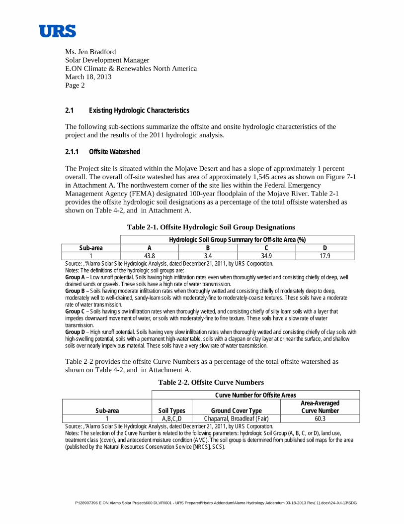
The following sub-sections summarize the offsite and onsite hydrologic characteristics of the project and the results of the 2011 hydrologic analysis. 2.1.1 Offsite Watershed The Project site is situated within the Mojave Desert and has a slope of approximately 1 percent overall. The overall off-site wateshed has area of approximately 1,545 acres as shown on Figure 7-1 in Attachment A. The northwestern corner of the site lies within the Federal Emergency Management Agency (FEMA) designated 100-year floodplain of the Mojave River. Table 2-1 provides the offsite hydrologic soil designations as a percentage of the total offsiste watershed as shown on Table 4-2, and in Attachment A.
Table 2-1. Offsite Hydrologic Soil Group Designations
Hydrologic Soil Group Summary for Off-site Area (%) Sub-area A B C D
1 43.8 3.4 34.9 17.9 Source: ,“Alamo Solar Site Hydrologic Analysis, dated December 21, 2011, by URS Corporation. Notes: The definitions of the hydrologic soil groups are: Group A – Low runoff potential. Soils having high infiltration rates even when thoroughly wetted and consisting chiefly of deep, well drained sands or gravels. These soils have a high rate of water transmission. Group B – Soils having moderate infiltration rates when thoroughly wetted and consisting chiefly of moderately deep to deep, moderately well to well-drained, sandy-loam soils with moderately-fine to moderately-coarse textures. These soils have a moderate rate of water transmission. Group C – Soils having slow infiltration rates when thoroughly wetted, and consisting chiefly of silty loam soils with a layer that impedes downward movement of water, or soils with moderately-fine to fine texture. These soils have a slow rate of water transmission. Group D – High runoff potential. Soils having very slow infiltration rates when thoroughly wetted and consisting chiefly of clay soils with high-swelling potential, soils with a permanent high-water table, soils with a claypan or clay layer at or near the surface, and shallow soils over nearly impervious material. These soils have a very slow rate of water transmission. Table 2-2 provides the offsite Curve Numbers as a percentage of the total offsite watershed as shown on Table 4-2, and in Attachment A.
Table 2-2. Offsite Curve Numbers
Curve Number for Offsite Areas
Sub-area Soil Types Ground Cover Type Area-Averaged Curve Number
1 A,B,C,D Chaparral, Broadleaf (Fair) 60.3 Source: ,“Alamo Solar Site Hydrologic Analysis, dated December 21, 2011, by URS Corporation. Notes: The selection of the Curve Number is related to the following parameters: hydrologic Soil Group (A, B, C, or D), land use, treatment class (cover), and antecedent moisture condition (AMC). The soil group is determined from published soil maps for the area (published by the Natural Resources Conservation Service [NRCS], SCS).
Ms. Jen Bradford Solar Development Manager E.ON Climate & Renewables North America March 18, 2013 Page 3
P:\28907396 E.ON Alamo Solar Project\600 DLVR\601 - URS Prepared\Hydro Addendum\Alamo Hydrology Addendum 03-18-2013 Rev( 1).docx\24-Jul-13\SDG
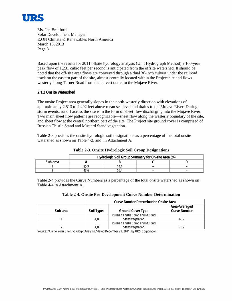
Based upon the results for 2011 offsite hydrology analysis (Unit Hydrograph Method) a 100-year peak flow of 1,231 cubic feet per second is anticipated from the offsite watershed. It should be noted that the off-site area flows are conveyed through a dual 36-inch culvert under the railroad track on the eastern part of the site, almost centrally located within the Project site and flows westerly along Turner Road from the culvert outlet to the Mojave River. 2.1.2 Onsite Watershed The onsite Project area generally slopes in the north-westerly direction with elevations of approximately 2,513 to 2,492 feet above mean sea level and drains to the Mojave River. During storm events, runoff across the site is in the form of sheet flow discharging into the Mojave River. Two main sheet flow patterns are recognizable—sheet flow along the westerly boundary of the site, and sheet flow at the central northern part of the site. The Project site ground cover is comprised of Russian Thistle Stand and Mustard Stand vegetation. Table 2-3 provides the onsite hydrologic soil designations as a percentage of the total onsite watershed as shown on Table 4-2, and in Attachment A.
Table 2-3. Onsite Hydrologic Soil Group Designations
Hydrologic Soil Group Summary for On-site Area (%) Sub-area A B C D
1 85.9 14.1 – – 2 43.6 56.4 – –
Table 2-4 provides the Curve Numbers as a percentage of the total onsite watershed as shown on Table 4-4 in Attachment A.
Table 2-4. Onsite Pre-Development Curve Number Determination
Curve Number Determination Onsite Area
Sub-area Soil Types Ground Cover Type Area-Averaged Curve Number
1 A,B Russian Thistle Stand and Mustard
Stand vegetation 66.7
2 A,B Russian Thistle Stand and Mustard
Stand vegetation 70.2 Source: “Alamo Solar Site Hydrologic Analysis,” dated December 21, 2011, by URS Corporation.
Ms. Jen Bradford Solar Development Manager E.ON Climate & Renewables North America March 18, 2013 Page 4
P:\28907396 E.ON Alamo Solar Project\600 DLVR\601 - URS Prepared\Hydro Addendum\Alamo Hydrology Addendum 03-18-2013 Rev( 1).docx\24-Jul-13\SDG
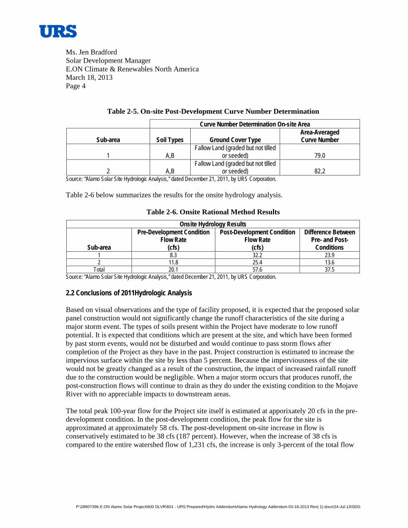
Table 2-5. On-site Post-Development Curve Number Determination
Curve Number Determination On-site Area
Sub-area Soil Types Ground Cover Type Area-Averaged Curve Number
1 A,B Fallow Land (graded but not tilled
or seeded) 79.0
2 A,B Fallow Land (graded but not tilled
or seeded) 82.2 Source: “Alamo Solar Site Hydrologic Analysis,” dated December 21, 2011, by URS Corporation. Table 2-6 below summarizes the results for the onsite hydrology analysis.
Table 2-6. Onsite Rational Method Results Onsite Hydrology Results
Sub-area
Pre-Development Condition Flow Rate
(cfs)
Post-Development Condition Flow Rate
(cfs)
Difference Between Pre- and Post-
Conditions 1 8.3 32.2 23.9 2 11.8 25.4 13.6
Total 20.1 57.6 37.5 Source: “Alamo Solar Site Hydrologic Analysis,” dated December 21, 2011, by URS Corporation. 2.2 Conclusions of 2011Hydrologic Analysis Based on visual observations and the type of facility proposed, it is expected that the proposed solar panel construction would not significantly change the runoff characteristics of the site during a major storm event. The types of soils present within the Project have moderate to low runoff potential. It is expected that conditions which are present at the site, and which have been formed by past storm events, would not be disturbed and would continue to pass storm flows after completion of the Project as they have in the past. Project construction is estimated to increase the impervious surface within the site by less than 5 percent. Because the imperviousness of the site would not be greatly changed as a result of the construction, the impact of increased rainfall runoff due to the construction would be negligible. When a major storm occurs that produces runoff, the post-construction flows will continue to drain as they do under the existing condition to the Mojave River with no appreciable impacts to downstream areas. The total peak 100-year flow for the Project site itself is estimated at apporixately 20 cfs in the pre-development condition. In the post-development condition, the peak flow for the site is approximated at approximately 58 cfs. The post-development on-site increase in flow is conservatively estimated to be 38 cfs (187 percent). However, when the increase of 38 cfs is compared to the entire watershed flow of 1,231 cfs, the increase is only 3-percent of the total flow
Ms. Jen Bradford Solar Development Manager E.ON Climate & Renewables North America March 18, 2013 Page 5
P:\28907396 E.ON Alamo Solar Project\600 DLVR\601 - URS Prepared\Hydro Addendum\Alamo Hydrology Addendum 03-18-2013 Rev( 1).docx\24-Jul-13\SDG
tributary to the site, which is not considered a significant impact when considering that the project is discharging directly to the Mojave River with no downstream properties directly impacted. Therefore, mitigation of the site for this increase is not considered warranted given the conservative nature of the hydrologic analysis. 3.0 SUPPLEMENTAL HYDROLOGIC ANALYSIS
In 2012 the solar Project facility design was expanded from approximately 95 acres to approximately 123 acres. This hydrologic analysis addendum focuses on how and to what extent inclusion of the larger area affects post-construction hydrologic conditions described in the previous study. This addendum provides supplemental analysis on existing Project site topography, soil types, vegetative cover and runoff conditions in the expanded Project area; and an assessment of how the expanded footprint affects post-construction conditions identified in the previous hydrologic analysis.
Please note: The Project also includes upgrades that SCE will make to an existing distribution line, including replacing existing wood poles with new wood poles and reconductoring the line. These activities are not expected to affect site hydrology and are not addressed further in this report.
3.1 Soil, Vegetative Cover, and Runoff Conditions
The additional site area was evaluated for potential hydrologic condition impacts for the inclusion of the larger proposed development area. In particular the expanded project area was evaluated in terms of hydrologic soil conditions, vegetative cover, and topography that may affect runoff conditions from the project site.
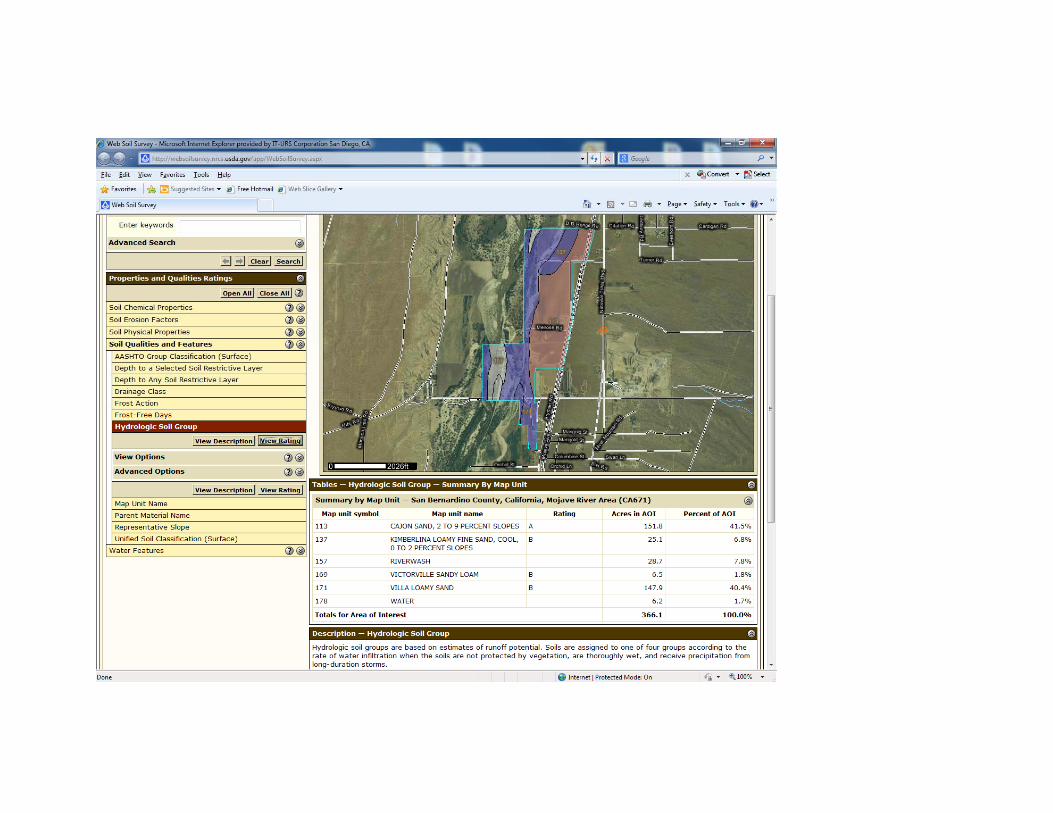
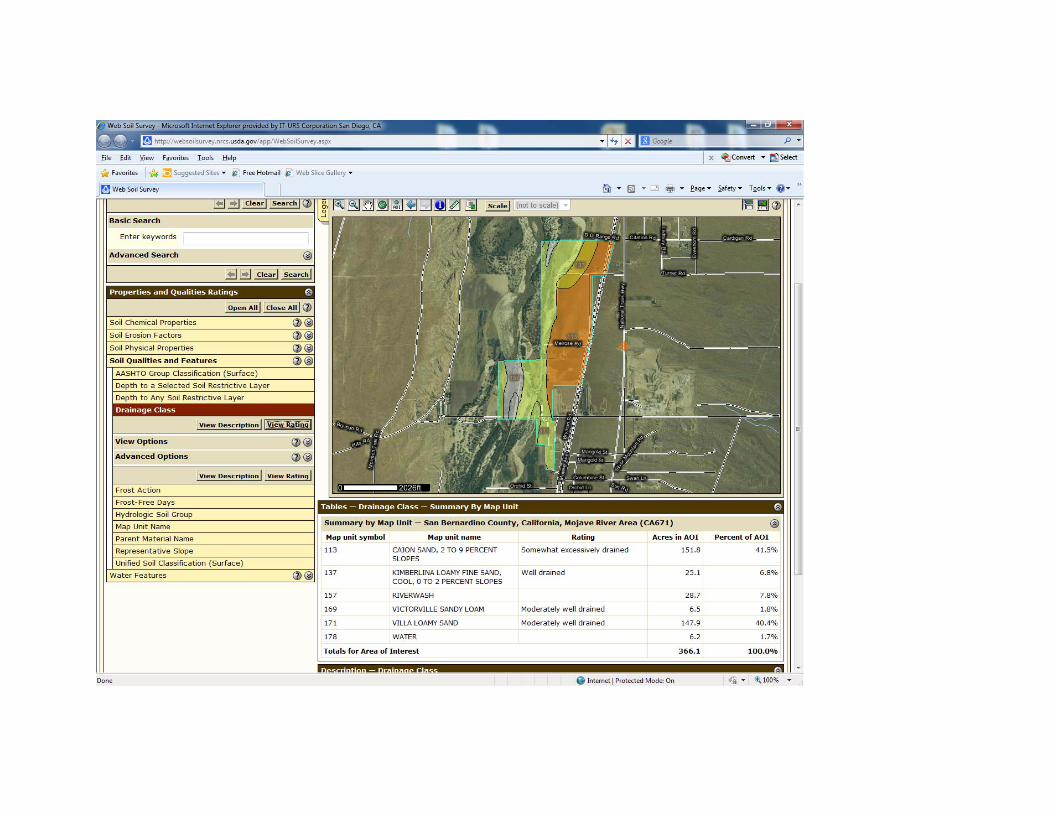
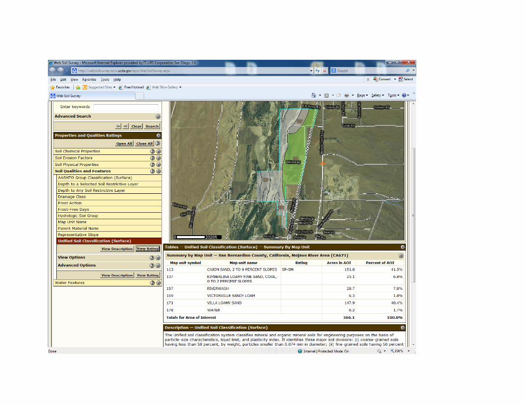
Based upon review of the additional project area it is not anticipated that the additional project area (including the previously proposed project area) will result in hydrologic conditions of concern or significant drainage impacts from a CEQA perspective. Attachment A provides an overview of the soils within the Project site area. Note that all soils in this area are categorized as Hydrologic Soil Groups A or B, which is consistent with the original classification provided in the 2011 Hydrologic Analysis. Vegetation coverage classes are also the same or are in the floodplain. Review of the latest topography indicates that the existing onsite flows follow similar patterns to the River. The natural terrain flows generally from west to east
3.2 Potential Hydrologic Changes
Based upon review of the latest soils, vegetation, and topography for the expanded project area, no significant drainage issues or increased runoff are anticipated, which is in keeping with the previous report findings.
Ms. Jen Bradford Solar Development Manager E.ON Climate & Renewables North America March 18, 2013 Page 6
P:\28907396 E.ON Alamo Solar Project\600 DLVR\601 - URS Prepared\Hydro Addendum\Alamo Hydrology Addendum 03-18-2013 Rev( 1).docx\24-Jul-13\SDG
4.0 CONCLUSIONS AND RECOMMENDATIONS
The expanded project area contains no new hydrologic soil types, and no additional drainages or other hydrologic conditions that require a complete revision of the previous hydrologic analysis. Inclusion of the expanded project area is not expected to substantially alter the findings of the hydrologic analysis of the Project Site as long as similar construction techniques are used, especially the use of I-beams or other types of embedded pier foundations which will not substantially change the imperviousness of the Project Site. The soil types on the Project site are hydrologic soil groups A and B, which are characterized as having moderate to low run-off potential. It is expected that the conditions which are present at the site currently, and which have been formed by past storm events, would continue to provide passage for storm flows through the site during storm events after completion of the Project. Runoff falling on the solar units will sheet flow across the face of the solar panels, fall to the ground, and then travel in the same drainage pattern as it flows in the pre-development condition This analysis along with the results of the previous hydrologic analysis demonstrate that the increase in runoff associated with the Project development (although large in terms of a percentage basis for onsite related flows) is negligible in terms of a regional perspective and potential to impact downstream properties. As a result, URS recommends the following (as indicated in the previous 2011 analysis): 1. Maintain the existing Turner Road channel on-site as shown on Attachment A, Figure 7-1. 2. Following approval by San Bernardino County Flood Control District, develop the
conceptual plan presented in this report into a detailed design which will further refine the results of the calculations presented in this report, and provide culvert sizes, and drawings showing site drainage for construction..
It is recommended that the drainage design concept provided in the 2011 report be implemented during the final design stage so that proper drainage design measures and erosion and sediment control measures be implemented in accordance with San Bernardino County requirements. Sincerely,
URS CORPORATION
Ms. Jen Bradford Solar Development Manager E.ON Climate & Renewables North America March 18, 2013 Page 7
P:\28907396 E.ON Alamo Solar Project\600 DLVR\601 - URS Prepared\Hydro Addendum\Alamo Hydrology Addendum 03-18-2013 Rev( 1).docx\24-Jul-13\SDG
Matthew C. Moore, P.E. Senior Project Engineer
MCM:mv Attachments: Attachment A – 2011 URS Hydrologic Analysis (under separate cover)
Attachment B – 2013 Hydrologic Soils Review
ATTACHMENT A
2011 URS Hydrologic Analysis
Alamo Solar Site Hydrologic Analysis
(under separate cover)

ATTACHMENT B
2013 Hydrologic Soils Review
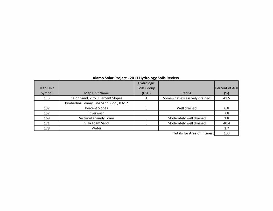
Map Unit Symbol Map Unit Name
Hydrologic Soils Group
(HSG) RatingPercent of AOI
(%)113 Cajon Sand, 2 to 9 Percent Slopes A Somewhat excessively drained 41.5
137Kimberlina Loamy Fine Sand, Cool, 0 to 2
Percent Slopes B Well drained 6.8157 Riverwash 7.8169 Victorville Sandy Loam B Moderately well drained 1.8171 Villa Loam Sand B Moderately well drained 40.4178 Water 1.7
100
Alamo Solar Project ‐ 2013 Hydrology Soils Review
Totals for Area of Interest