1 pertemuan 13 masa depan sig matakuliah: t0234 / sistem informasi geografis tahun: 2005 versi:...
Post on 21-Dec-2015
217 views
TRANSCRIPT
1
Pertemuan 13Masa Depan SIG
Matakuliah : T0234 / Sistem Informasi Geografis
Tahun : 2005
Versi : 01/revisi 1
2
Learning Outcomes
Pada akhir pertemuan ini, diharapkan mahasiswa akan mampu :
• Memperkirakan arah perkembangan dari SIG di masa yang akan datang (C2,TIK13)
3
Outline Materi
• Materi 1 : Permasalahan SIG masa kini
• Materi 2 : Perkembangan teknologi masa depan
• Materi 3 : Pengaruh perkembangan teknologi terhadap SIG
4
GIS in the 1990s
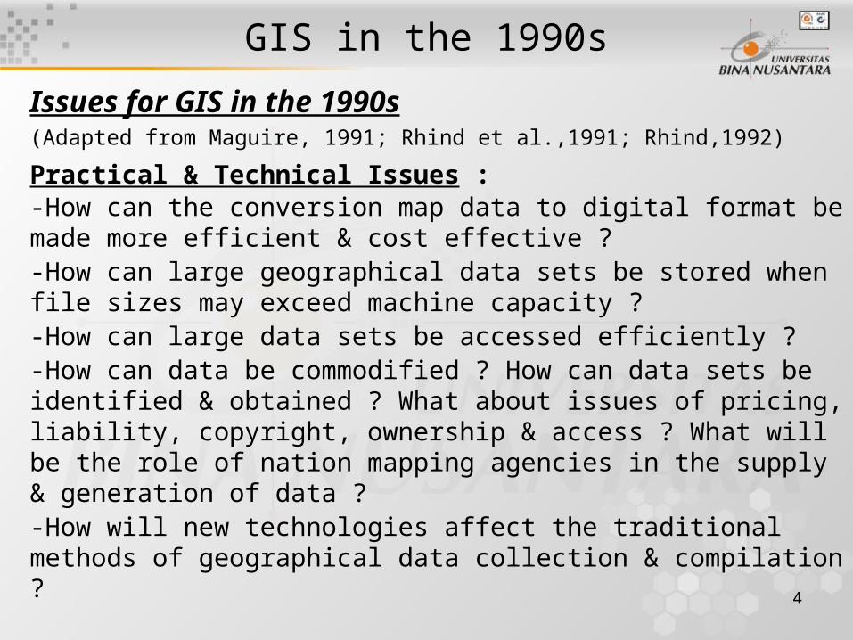
Issues for GIS in the 1990s(Adapted from Maguire, 1991; Rhind et al.,1991; Rhind,1992)
Practical & Technical Issues :-How can the conversion map data to digital format be made more efficient & cost effective ?-How can large geographical data sets be stored when file sizes may exceed machine capacity ?-How can large data sets be accessed efficiently ?-How can data be commodified ? How can data sets be identified & obtained ? What about issues of pricing, liability, copyright, ownership & access ? What will be the role of nation mapping agencies in the supply & generation of data ?-How will new technologies affect the traditional methods of geographical data collection & compilation ?
5
GIS in the 1990s. (2)Conceptual GIS Issues :
-How can data models represent the complexity of the real world more accurately ?-How can GIS cope with different types of data about our world, for example data that can not be represented by co-ordinates or pixels (sound, photographs, video & free-form text) ? How can GIS complement other technologies & techniques for handling these data ? -How can GIS database functions be linked with more advanced modeling capabilities, such as those available in other software ?-How can uncertainty in data sets & in analysis operations be dealt with ?
6
GIS in the 1990s. (3)Implementation & user issues :
-How can GIS be made easier to use ? What makes an interface effective & appropriate ? -What are the costs & benefits of introducing GIS ? How can these be assessed ?-What is the impact of GIS on an organization ? What can be learned from successful & unsuccessful applications ?-How can GIS awareness be raised, & what education & training is necessary for organizations ? How can training in particular system be improved ?-How will the rigorous, objective perspective of GIS be adapted to the imprecise, subjective world of human reasoning & decision making ?
7
Twenty predictions for GIS(Adapted from : Rhind, 1992; Rhind et al., 1991)
A. Conceptual & Technical Predictions :1. Data models will be developed to handle 3D & time characteristics, & complex interactions between objects.2. There will be new analysis & support functions to allow, for example, the tracking of data lineage or visual interaction with the stages in an analysis process.3. There will be support for quality assurance & quality control.4. Support for multimedia will become common.5. GIS & GPS developments will occur. GIS & GPS will be integrated for data collection & compilation, & a decline in mass digitizing will be accompanied by growth in use of GPS. 6. Tools for visualizing 3D & time-dependent data will be developed.7. There will be a convergence in general-purpose GIS, with most system running under Unix & functionality becoming more similar.8. Sector-specific products will probability appear.
8
Twenty predictions for GIS. (2) B. Market Predictions :
9. Vendors will attempt to differentiate products by efficiency of coding, friendship schemes & other means.
10. The bulk of the GIS market will be outside the USA. Europe & Japan will challenge American supremacy, & political factors will ensure that software & system creation will be carried out in multiple locations.
11. Users will want local customization of global products, for example translation into their own language.
12. There will be a growth in "value-added services".
9
Twenty predictions for GIS. (3)C. Data Predictions :
13. Digitizing will be done where it is cheapest. The peak off mass digitizing will be over in the USA & UK by 2000.14. The data volume problem will disappear in some applicati-ons (due to, instance, CD-ROM) 15. Ownership of data will become an issue, & data issue will continue to be affected by government policies. 16. Concern over privacy & confidentiality of data will be an issue in socio-economic applications.
10
Twenty predictions for GIS. (4)D. Human & Organizational Predictions :
17. Improved techniques will become available for the GIS acquisition & project management process.
18. GIS will become part of wider management information system in many organizations.
19. The skills & professionalism of individuals involved will influence the success of applications.
20. Education & training will have to concentrate on setting & demonstrating standards as well as curriculum contents.
11
Progress on Conceptual & Technical Issues
-The third & fourth dimensions are poorly catered for, & there is an overemphasis on the map & image presentation of spatial data.-Commercial systems using object-oriented data models are now available.-No widely used GIS with established methods for handling three-dimensional & temporal data, despite advances in related fields such as geological modeling.-Links to other software are often provided in GIS products.-Model & menu builders exist in some packages to allow integration of analysis from elsewhere, or the addition of new functions programmed by the user.-Visualization of both 3D & time data is also an area of research & development.-Data lineage tracking functions in some software have assisted quality control.
12
Progress on Conceptual & Technical Issues. (2)
-GIS applications now include scanned images (for instance, pictures of property & assets), but sound & video are less common.
-To be object-based spatial-nodal videos on the WWW
-The integration of GIS & GPS has progressed further than Rhind perhaps to expected.
-GPS receivers can frequently collect attribute as well as positional data, & field-base computing systems combining GIS & GPS technology allow direct plotting of data on a map base whilst in the field.-PC based products under Windows OS more popular than Unix.-Most systems can now handle rasters & vectors, & data exchange is standard.
13
Progress on Products & Markets
-Develop products for different market sector, because of PC-based systems' development.-These handle specific applications & offer targeted functionality.-Hybrid GIS/CAD systems have emerged.-Other software products, including databases, spreadsheets & statistical analysis packages, have also been given mapping extensions.-The vendors need to differentiate their products to promote them to potential customers.-The market outside the USA is certainly expanding, such as Netherlands, UK & Australia.-Translation of products into languages such as Russian & Chinese.-Growth of users in Eastern Europe, Latin America, Africa & Far East.-Limited availability & poor quality of data can be a major obstacle, for example in Latin America.
14
Progress on Products & Markets (2)
-Developments in GPS & Remote Sensing will help ease these data problems, & data availability is being assisted by the provision of some data sets freely over the Internet.
-Consultant services to meet one-off applications have been an area of with particular expansion, some consultants also producing custom software.
15
Progress on Data Issues
-In the USA & UK, as the national mapping agencies have completed the initial encoding of their resources, & many of the major utilities are completing their data capture programs.-The new challenges are in updating & revising these data.-In the digitizing of UK population census boundaries was put out to tender and subcontracted to more than one organization to ensure the quality & competitiveness.-Mass digitizing moving to Far East will not become a reality.-The development of automatic digitizing tools & increased resolution & availability of good aerial photography & satellite imagery offer alternative. -The data produced by digitizing need to be stored, & many of the digital data sets that have been created are huge.-In the USA, spatial information is regarded as public good, with access available to every citizen for a nominal charge.
16
Progress on human & Organizational Issues
-The number of business applications of GIS has expanded, there has been a renewal of interest in making the business case for GIS.-GIS will become part of wider MIS in many organizations is certainly true for commercial applications.-Certainly training & educational opportunities have expanded.-In the UK, GIS has appeared in the National Curriculum.-In the USA, the NCGIA's core curriculum has been widely adopted in universities and colleges.-The vendors have been addressing the needs of the K-12 (Kindergarten to year 12) GIS curriculum.-Courses available at technician level, analyst level & manager level; by traditional study or distance learning; or even over the Internet.
17
WHERE NEXT for GIS
# Can GIS be truly three-dimensional ?# Can real time GIS become reality ?# Can computers be used to model the interactions between features ?# Is there a better way of modeling geographical data than the current raster/vector/object-oriented paradigms ?# Are there other ways of representing space that do not rely on maps ?
18
WHERE NEXT for GIS. (2)
Goodchild, 1995 considers that GIS are :
-Two-dimensional with limited abilities to handle the third dimension
-Static, with limited abilities to cope with temporal data
-Good at capturing the physical position of objects
-Offering a diverse & confusing set of the data models
-Still dominated by the idea of a map, or view of a spatial database as a collection of digital maps.
19
Next GIS Applications-Maquire (1991) perhaps everyone use GIS every day for routine operations.
-GIS infiltrating other areas of IT, such as spreadsheet, database & graphics packages.
-Maps & mapping functions are available over the Internet to anyone who has a modem.
-GIS is appearing in everyday use in other type applications.
-All cars will have a navigation aid & map will be queried & retrieved over the Internet.
-Virtual field trip are being developed as learning aid (Fisher et al., 1997)
-Computer games offer exciting simulations of the real world with which user interact.
20
Next GIS Applications (2)
-GIS are being mooted as tools for generating ideas, & for improving the participation of all players in the decision-making process.
-Intelligent GIS will provide inputs to the highest level within organizations.
-GIS is used for strategic advice, & systems required are customized, expensive products that will be provided by niche players in the GIS marketplace.
21
Next GIS Technology
-Future users of GIS will expect systems with tools for multimedia, for real-time modeling of complex phenomena and for better representation of the real world.
-Geographical Analysis Machine (GAM) might become more generally available.
-Further development of open systems will be a major theme in coming years.
22
Emphasizing the Information
-Highlighted barriers to the development of GIS, which focused in the main on data issues, such as referencing, standards & confidentiality.
-The data mountain continues to grow, with data being collected at every opportunity.
-More and more data have a spatial references.
-There is a need for new techniques to use this data mountain resources.
-Data issues are still foremost among problems & challenges for the future.
23
People & GIS
-Two areas of skill & knowledge in the basic understanding of geographical phenomena : Spatial Thinking & High level Technical Skill.
24
Predictions for 21 Century
-New & improved data models will be developed, especially for true 3D modeling, global data sets & temporal modeling-Developments in related fields will influence developments in GIS (For examples : AI, NN, Geocomputing, Spatial Statistics, Multimedia, VR, the Internet, Office Packages)-There will be a continued repackaging of products to meet sector-scientific needs, and with continued dominance of the PC, further expansion of the desktop market-There will be further additions to GIS functionality, For examples : Much-needed exploratory data analysis & error analysis.-Data collection and exchange will continue to be influenced by GPS development, coupled with future developments in satellite communication & data collection methods
25
Predictions for 21 Century. (2)
-Peripherals such as high-quality printers will become widely available, possibly through online Internet Service Providers
-Data storage will cease to be issue, although the development of real-time systems will challenge even the largest storage devices.
-The ideas of interoperability, allowing the use of the most appropriate software tool for the solution of a particular problem, will extend to influence other areas of GIS, including data & education
-New education & training products will be developed to address skill shortages for both potential users, the research & development needs of the GIS industry.
26
Penutup
• Mahasiswa diharapkan telah mampu memperkirakan arah perkembangan dari SIG di masa yang akan datang .