1 international urban development workshop 12 and 13 november 2008 pretoria, south africa revised...
TRANSCRIPT
1
INTERNATIONAL URBAN DEVELOPMENT WORKSHOP
12 and 13 NOVEMBER 2008Pretoria, South Africa
revised December 2008
Gauteng urban spatial structure
Evolution of population densities since 1990 Could a new transport network accelerate the evolution of Gauteng spatial structure toward
"normalcy"?
By Alain Bertaud
Additional papers can be downloaded from:http://alain-bertaud.com
2
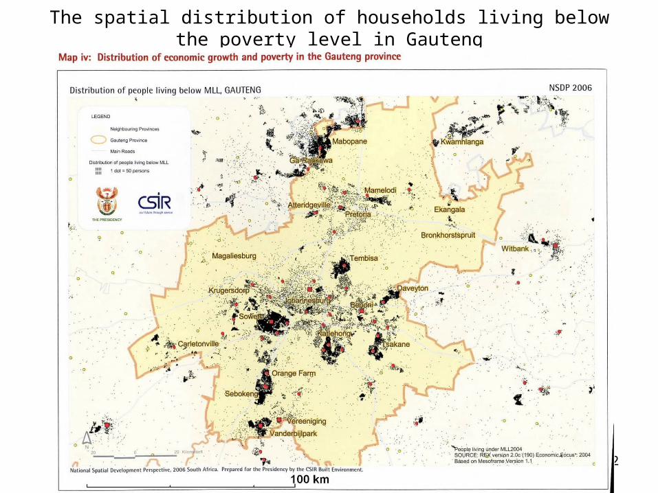
The spatial distribution of households living below the poverty level in Gauteng
3
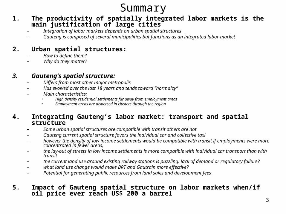
Summary1. The productivity of spatially integrated labor markets is the main justification of
large cities– Integration of labor markets depends on urban spatial structures – Gauteng is composed of several municipalities but functions as an integrated labor market
2. Urban spatial structures: – How to define them? – Why do they matter?
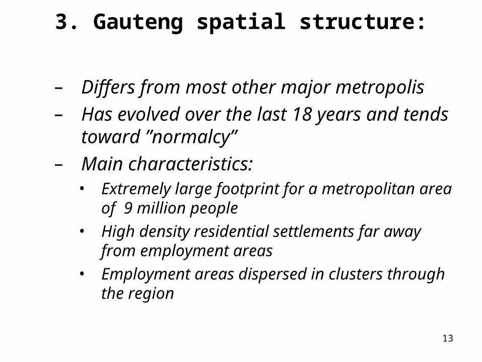
3. Gauteng’s spatial structure:– Differs from most other major metropolis– Has evolved over the last 18 years and tends toward ”normalcy” – Main characteristics:
• High density residential settlements far away from employment areas• Employment areas are dispersed in clusters through the region
4. Integrating Gauteng’s labor market: transport and spatial structure– Some urban spatial structures are compatible with transit others are not – Gauteng current spatial structure favors the individual car and collective taxi– however the density of low income settlements would be compatible with transit if employments were more
concentrated in fewer areas,– the lay-out of streets in low income settlements is more compatible with individual car transport than with transit– the current land use around existing railway stations is puzzling: lack of demand or regulatory failure?– what land use change would make BRT and Gautrain more effective?– Potential for generating public resources from land sales and development fees
5. Impact of Gauteng spatial structure on labor markets when/if oil price ever reach US$ 200 a barrel
4
Summary Slide
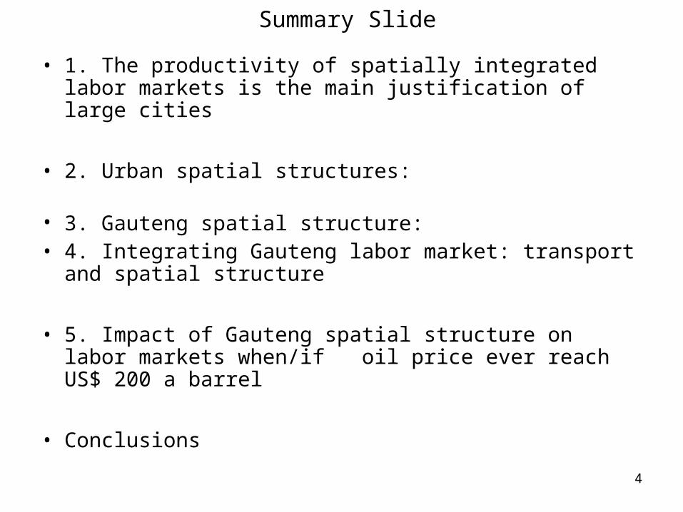
• 1. The productivity of spatially integrated labor markets is the main justification of large cities
• 2. Urban spatial structures:
• 3. Gauteng spatial structure:• 4. Integrating Gauteng labor market: transport and
spatial structure
• 5. Impact of Gauteng spatial structure on labor markets when/if oil price ever reach US$ 200 a barrel
• Conclusions
5
1. The productivity of spatially integrated labor markets is the main justification of large cities
6
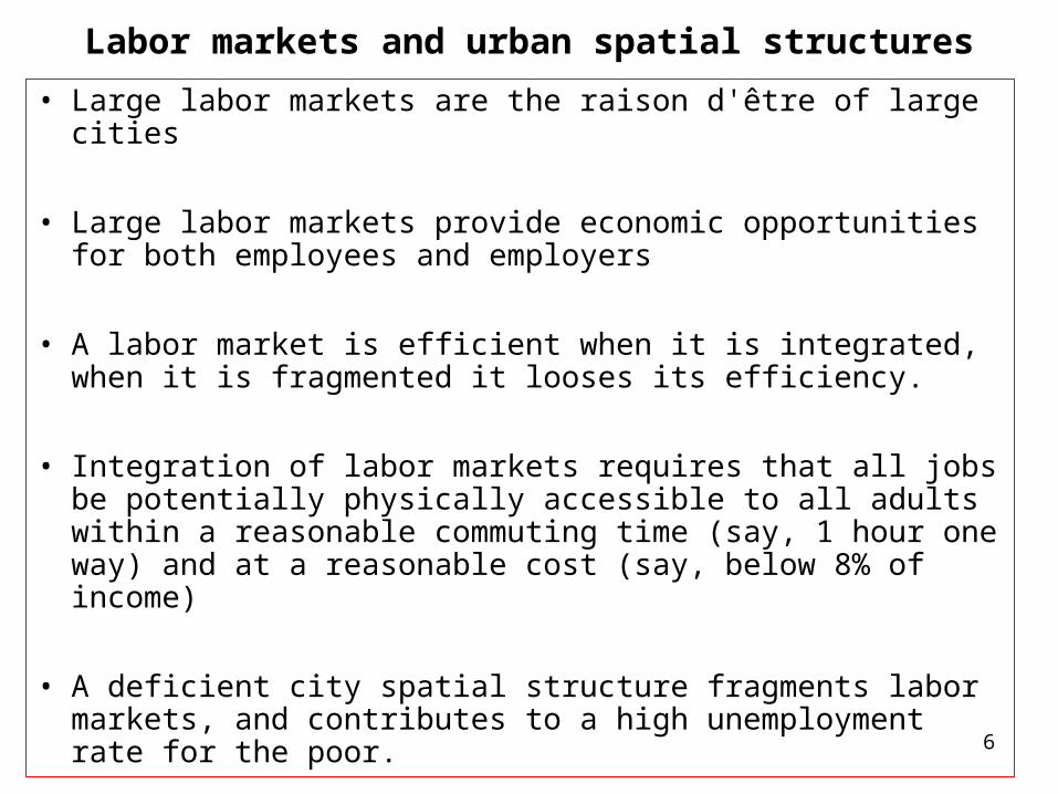
Labor markets and urban spatial structures
• Large labor markets are the raison d'être of large cities
• Large labor markets provide economic opportunities for both employees and employers
• A labor market is efficient when it is integrated, when it is fragmented it looses its efficiency.
• Integration of labor markets requires that all jobs be potentially physically accessible to all adults within a reasonable commuting time (say, 1 hour one way) and at a reasonable cost (say, below 8% of income)
• A deficient city spatial structure fragments labor markets, and contributes to a high unemployment rate for the poor.
7
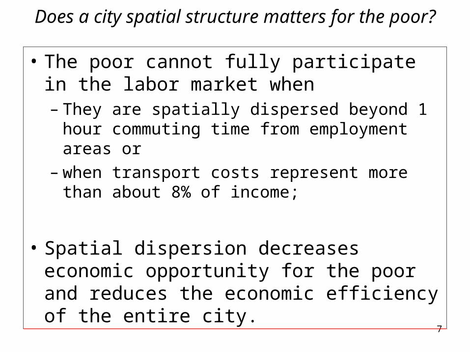
Does a city spatial structure matters for the poor?
• The poor cannot fully participate in the labor market when – They are spatially dispersed beyond 1 hour
commuting time from employment areas or – when transport costs represent more than
about 8% of income;
• Spatial dispersion decreases economic opportunity for the poor and reduces the economic efficiency of the entire city.
8
2. Urban spatial structures:
• How to define them?
• Why do they matter?
9
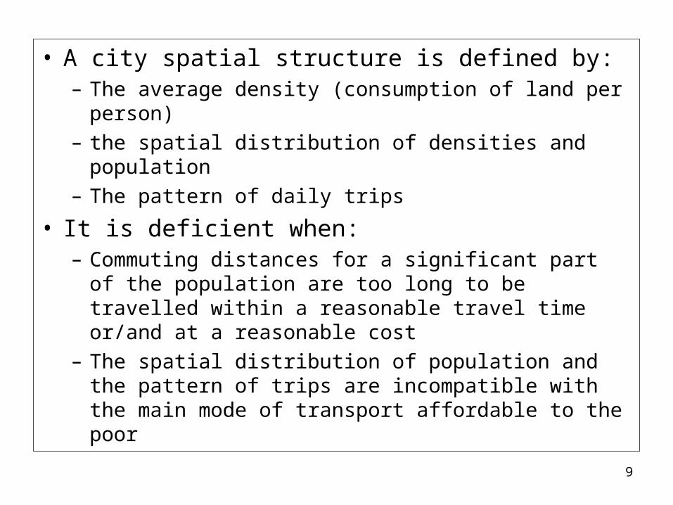
• A city spatial structure is defined by: – The average density (consumption of land per
person) – the spatial distribution of densities and population– The pattern of daily trips
• It is deficient when:– Commuting distances for a significant part of the
population are too long to be travelled within a reasonable travel time or/and at a reasonable cost
– The spatial distribution of population and the pattern of trips are incompatible with the main mode of transport affordable to the poor
10
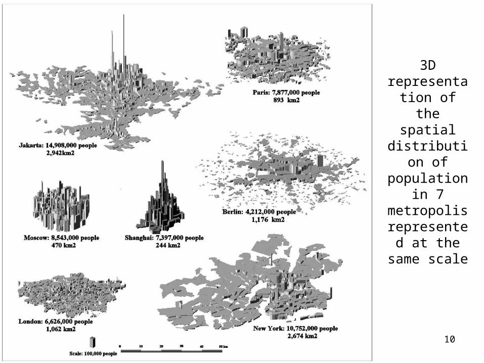
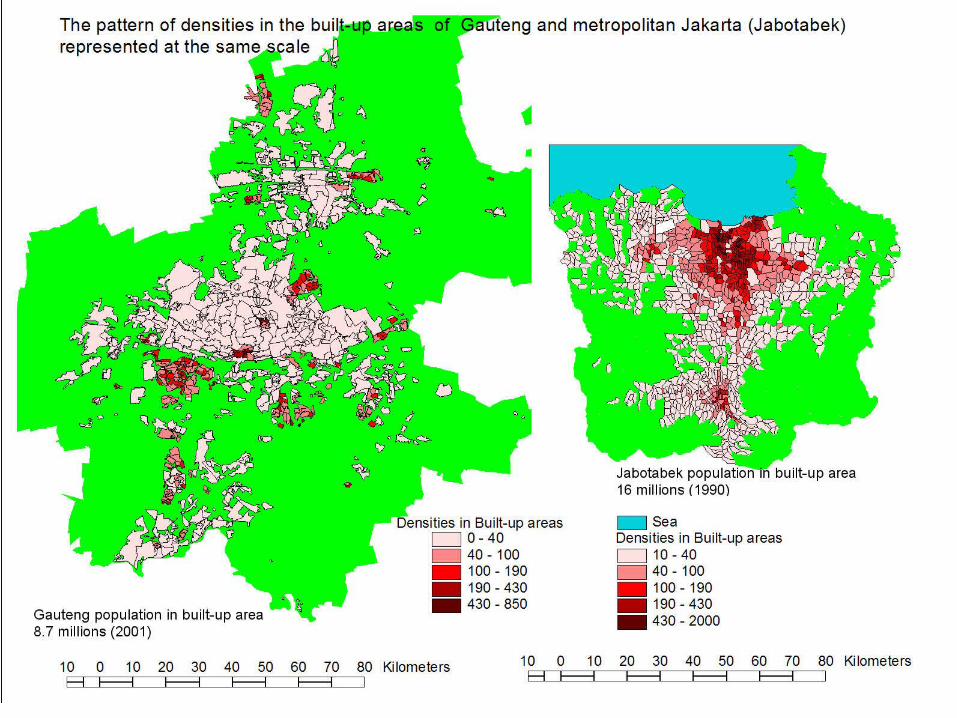
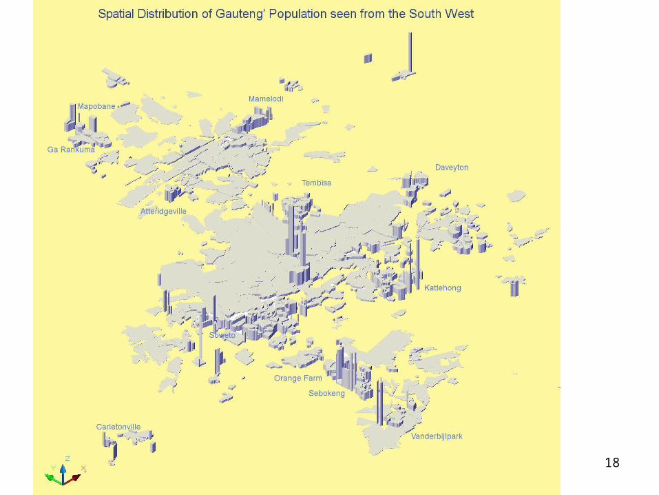
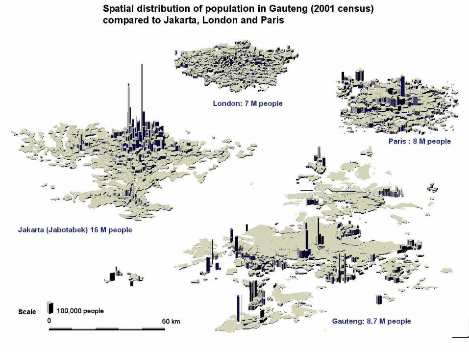
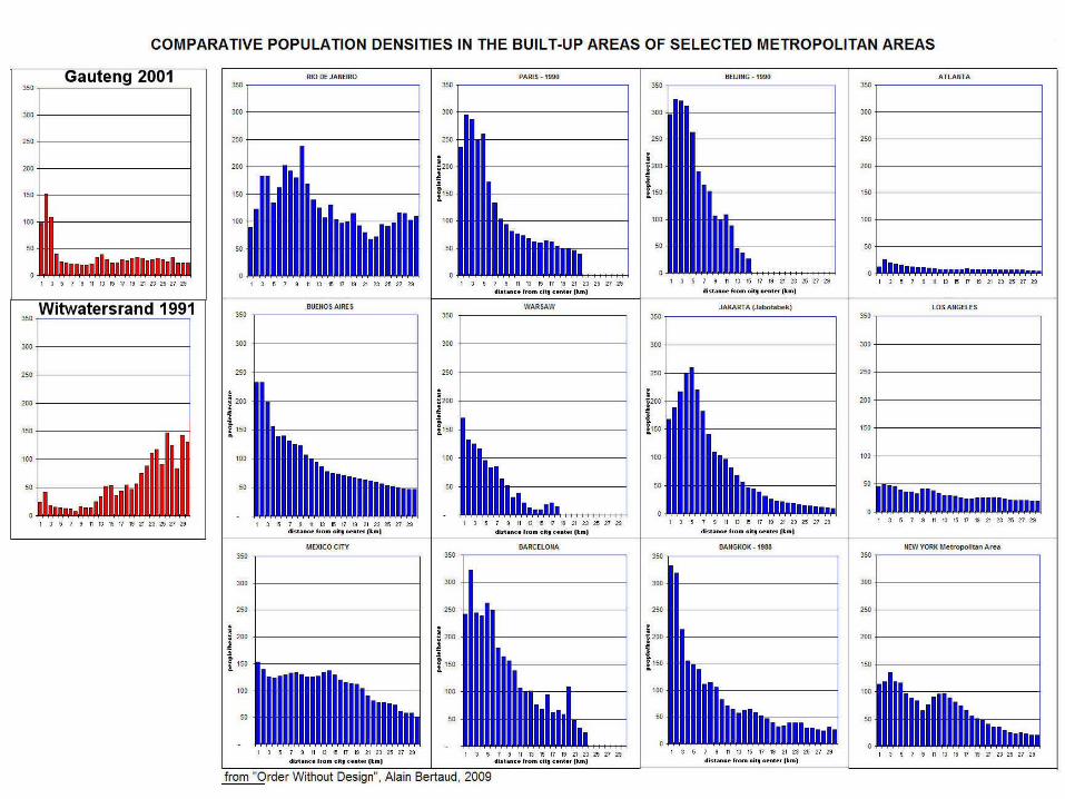
3D representation of the spatial distribution of population in 7 metropolis
represented at the same
scale
11
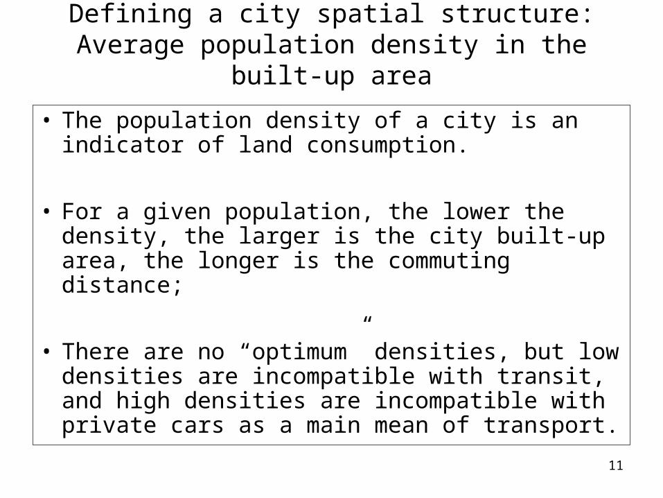
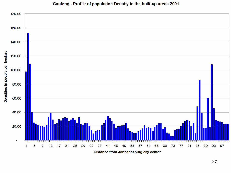
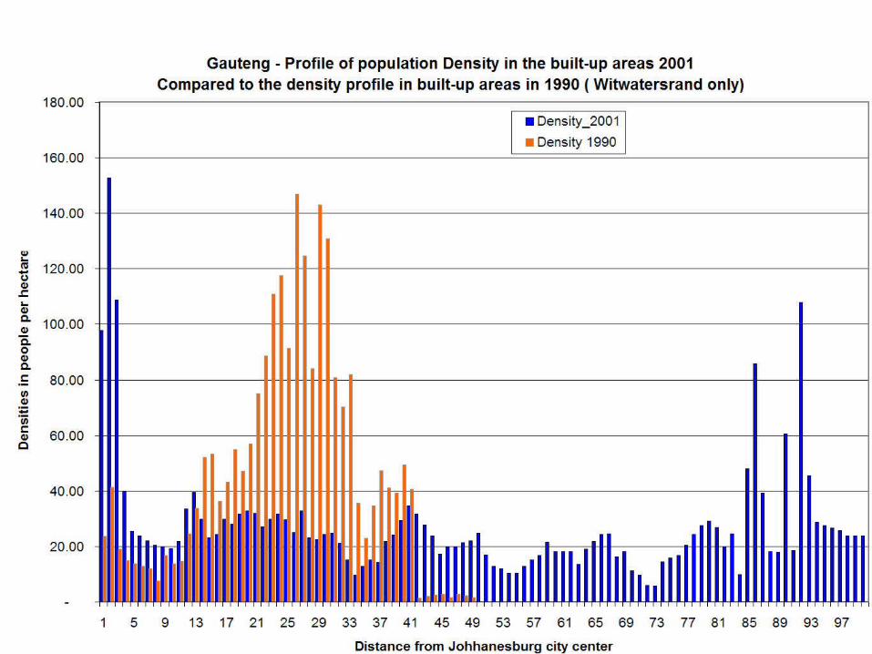
Defining a city spatial structure: Average population density in the built-up area
• The population density of a city is an indicator of land consumption.
• For a given population, the lower the density, the larger is the city built-up area, the longer is the commuting distance;
• There are no “optimum” densities, but low densities are incompatible with transit, and high densities are incompatible with private cars as a main mean of transport.
12
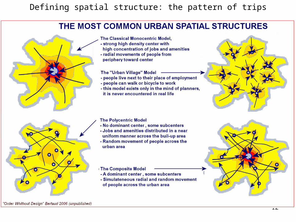
Defining spatial structure: the pattern of trips
13
– Differs from most other major metropolis– Has evolved over the last 18 years and
tends toward ”normalcy” – Main characteristics:
• Extremely large footprint for a metropolitan area of 9 million people
• High density residential settlements far away from employment areas
• Employment areas dispersed in clusters through the region
3. Gauteng spatial structure:

14
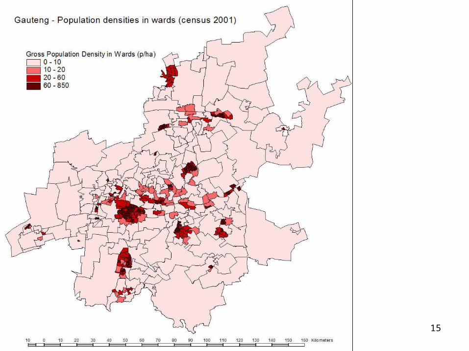
15
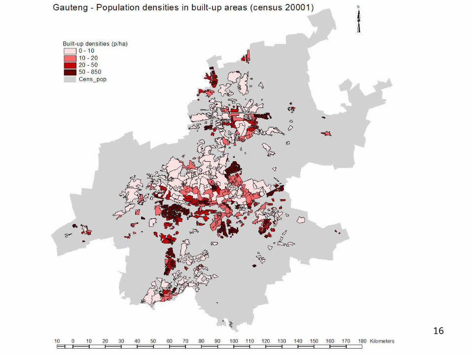
16
17
18
19
20
21
22
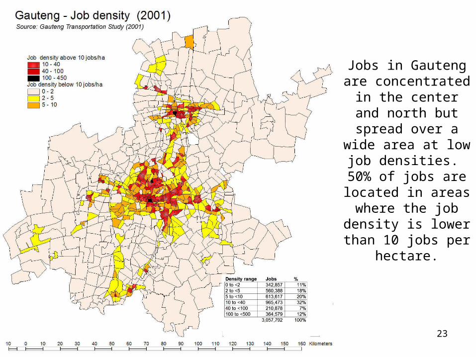
23
Jobs in Gauteng are concentrated in the center and north but spread over a wide
area at low job densities.
50% of jobs are located in areas
where the job density is lower than 10 jobs
per hectare.
24
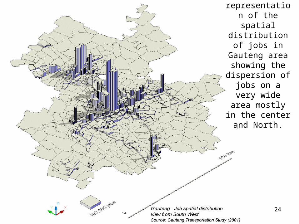
3D representation of the spatial distribution of
jobs in Gauteng area showing the dispersion of jobs
on a very wide area mostly in the center and North.
25
4. Integrating Gauteng labor market: transport and spatial structure
– Some urban spatial structures are compatible with transit others are not
– Gauteng current spatial structure favors the individual car and collective taxi
– However, the density of low income settlements would be compatible with transit if employments were more concentrated in fewer areas,
– the lay-out of streets in low income settlements is more compatible with individual car transport than with transit
– the current land use around existing railway stations is puzzling: lack of demand or regulatory failure?
– what land use change would make BRT and Gautrain more effective?
26
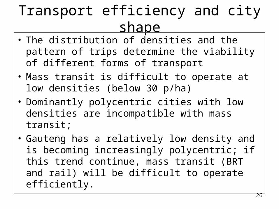
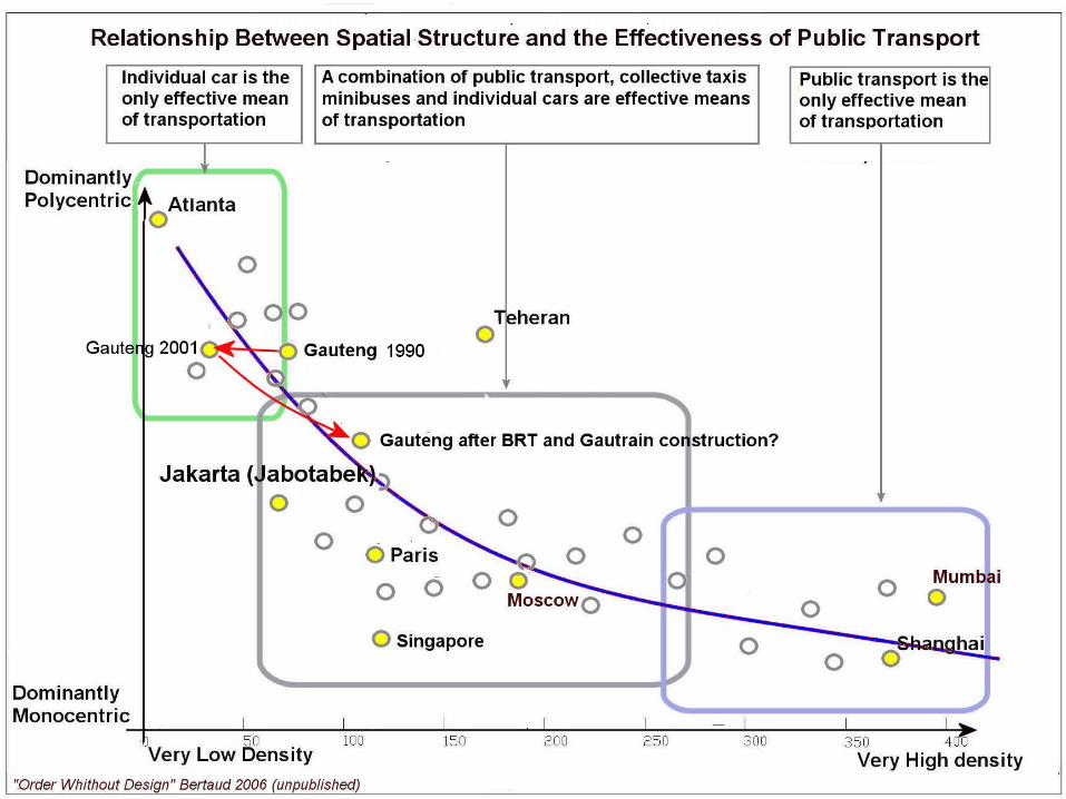
Transport efficiency and city shape
• The distribution of densities and the pattern of trips determine the viability of different forms of transport
• Mass transit is difficult to operate at low densities (below 30 p/ha)
• Dominantly polycentric cities with low densities are incompatible with mass transit;
• Gauteng has a relatively low density and is becoming increasingly polycentric; if this trend continue, mass transit (BRT and rail) will be difficult to operate efficiently.
27
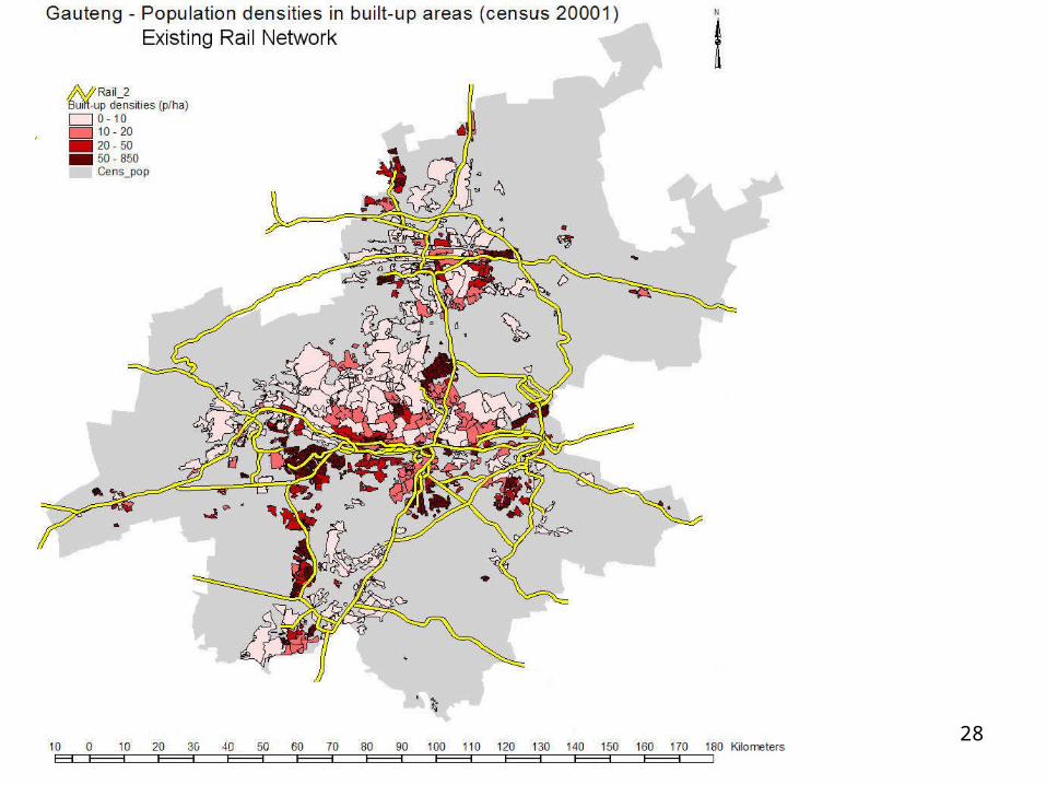
28
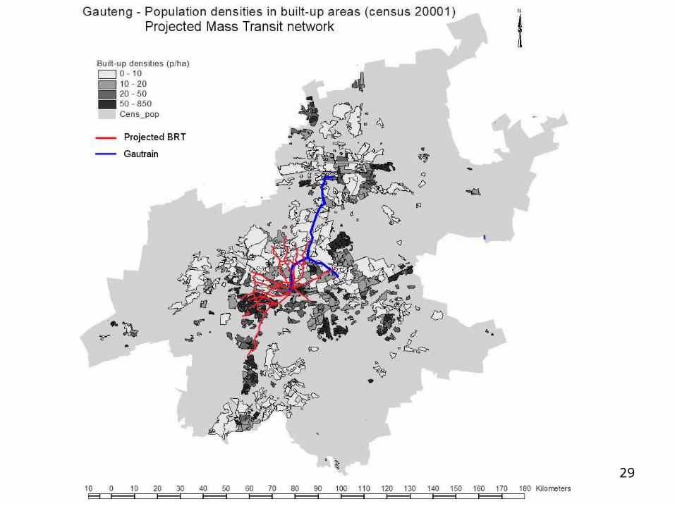
29
30
Settlements pattern, economic activities and mass transit
• Residential settlements in Gauteng are less dense, have higher standards of roads and open space and have less mixed land use than residential settlements in other cities of comparative income and size.
• Backyard shacks are demand driven and contribute to increase densities in a positive way
• The fragmentation of residential areas and the dispersion of employment centers, if it continues, will make the operation of mass transit and BRTs expensive to operate and not very convenient to the users
31
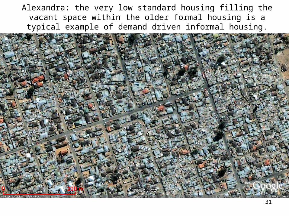
Alexandra: the very low standard housing filling the vacant space within the older formal housing is a typical example of demand driven informal
housing.
32
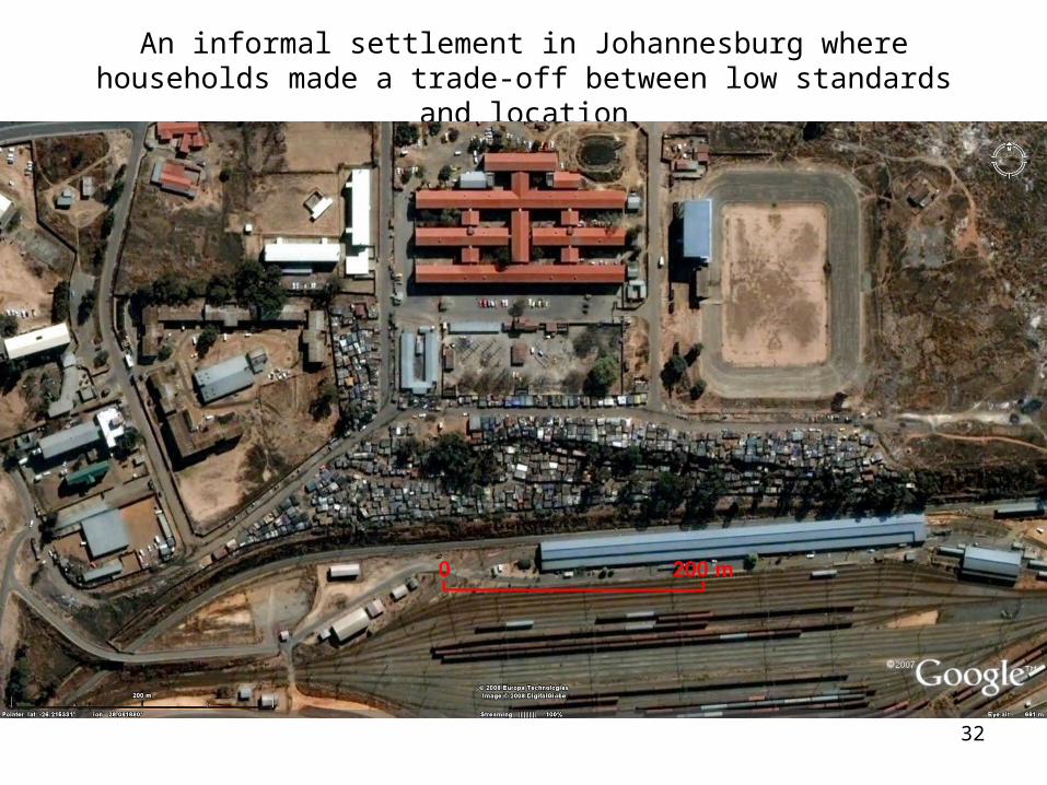
An informal settlement in Johannesburg where households made a trade-off between low standards and location
33
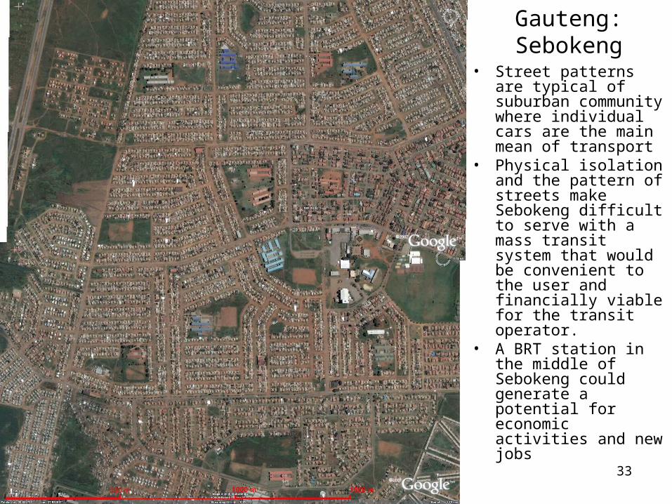
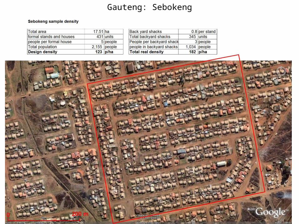
Gauteng:Sebokeng
• Street patterns are typical of suburban community where individual cars are the main mean of transport
• Physical isolation and the pattern of streets make Sebokeng difficult to serve with a mass transit system that would be convenient to the user and financially viable for the transit operator.
• A BRT station in the middle of Sebokeng could generate a potential for economic activities and new jobs
34
Gauteng: Sebokeng
35
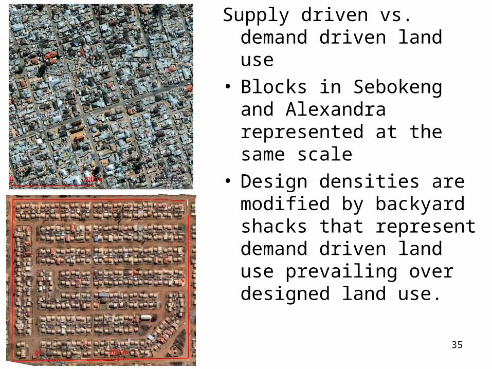
Supply driven vs. demand driven land use
• Blocks in Sebokeng and Alexandra represented at the same scale
• Design densities are modified by backyard shacks that represent demand driven land use prevailing over designed land use.
36
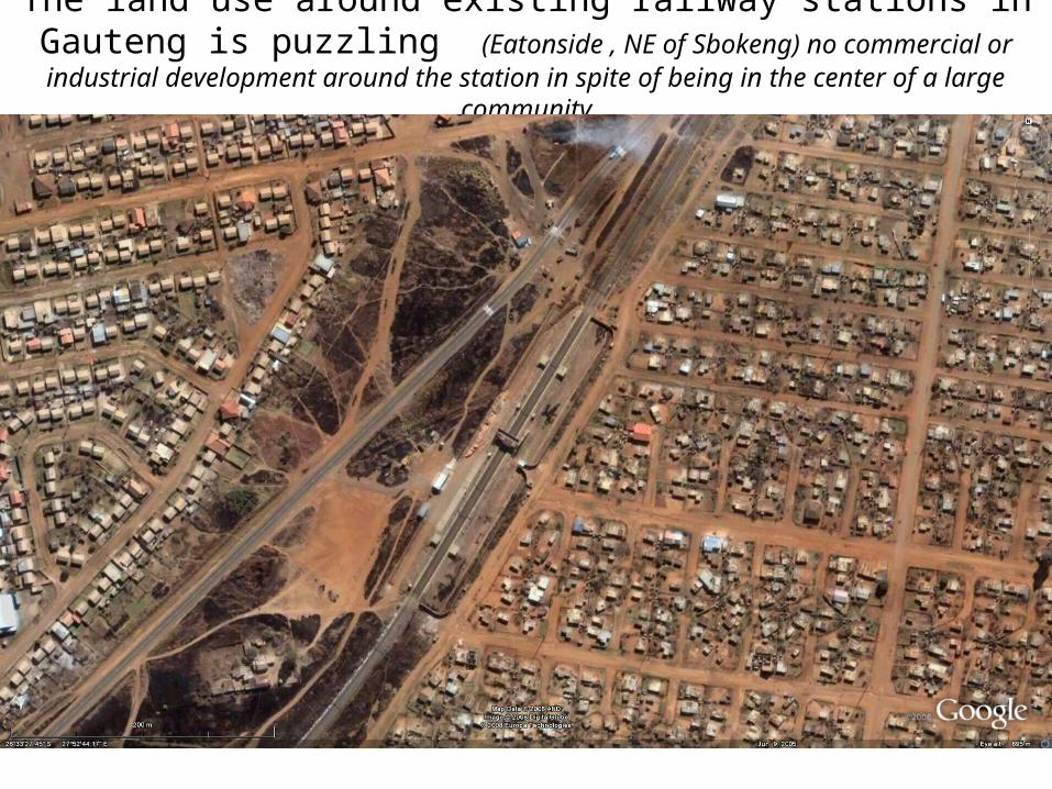
The land use around existing railway stations in Gauteng is puzzling (Eatonside , NE of Sbokeng) no commercial or industrial development
around the station in spite of being in the center of a large community
37
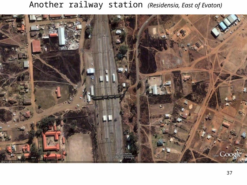
Another railway station (Residensia, East of Evaton)
38
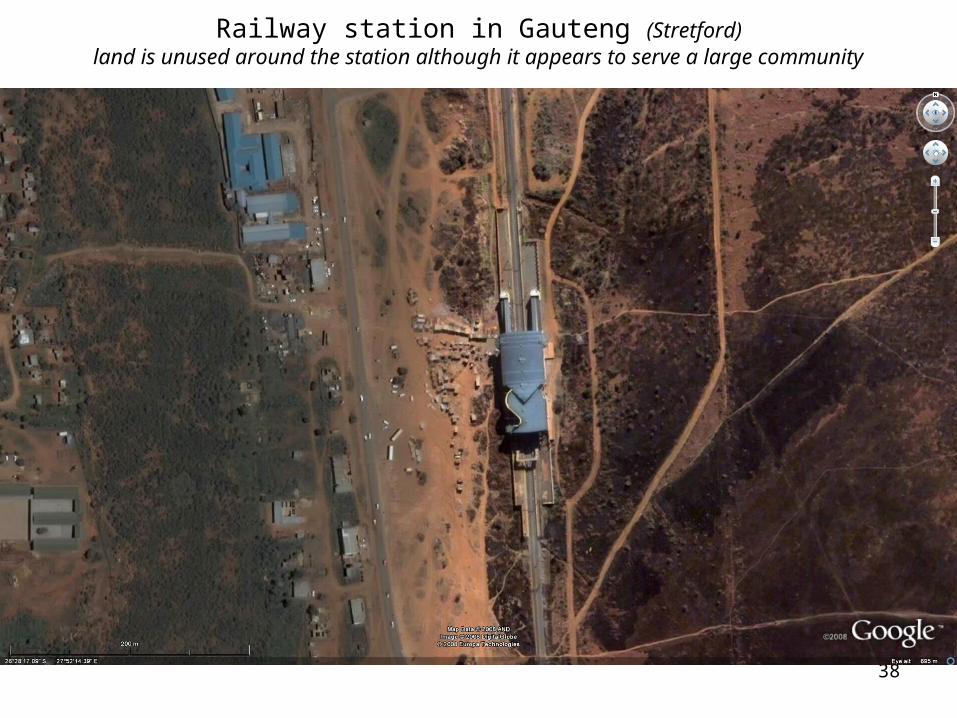
Railway station in Gauteng (Stretford)land is unused around the station although it appears to serve a large community
39
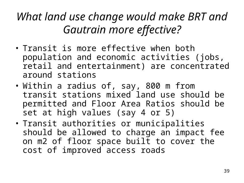
What land use change would make BRT and Gautrain more effective?
• Transit is more effective when both population and economic activities (jobs, retail and entertainment) are concentrated around stations
• Within a radius of, say, 800 m from transit stations mixed land use should be permitted and Floor Area Ratios should be set at high values (say 4 or 5)
• Transit authorities or municipalities should be allowed to charge an impact fee on m2 of floor space built to cover the cost of improved access roads
40
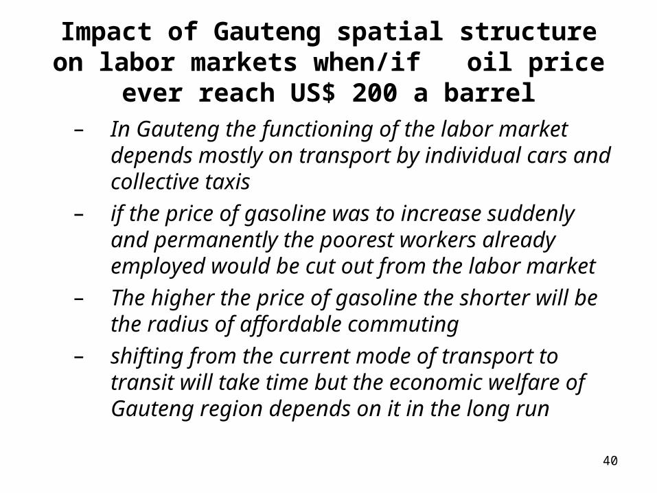
Impact of Gauteng spatial structure on labor markets when/if oil price ever reach US$ 200 a
barrel– In Gauteng the functioning of the labor market
depends mostly on transport by individual cars and collective taxis
– if the price of gasoline was to increase suddenly and permanently the poorest workers already employed would be cut out from the labor market
– The higher the price of gasoline the shorter will be the radius of affordable commuting
– shifting from the current mode of transport to transit will take time but the economic welfare of Gauteng region depends on it in the long run
41
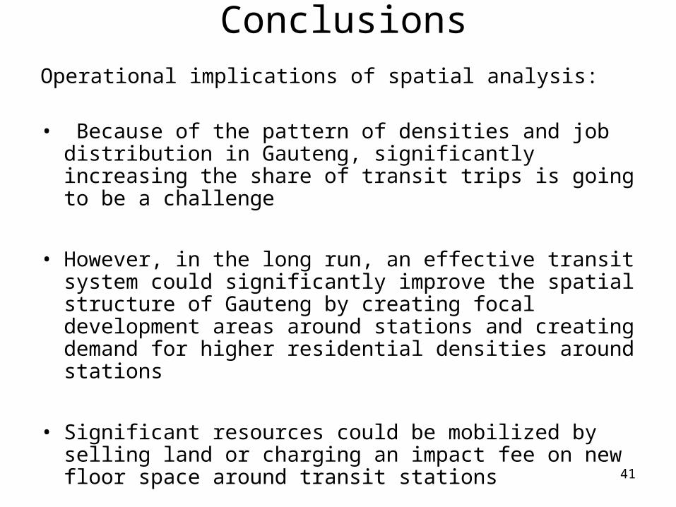
ConclusionsOperational implications of spatial analysis:
• Because of the pattern of densities and job distribution in Gauteng, significantly increasing the share of transit trips is going to be a challenge
• However, in the long run, an effective transit system could significantly improve the spatial structure of Gauteng by creating focal development areas around stations and creating demand for higher residential densities around stations
• Significant resources could be mobilized by selling land or charging an impact fee on new floor space around transit stations
42
Annex on the evolution of urban spatial structures
• Urban spatial structures are inherited from the past but they evolve and adapt with time
• There are no models, no optimum urban structures, or even optimum densities
• The best approach to improve an urban spatial structure is to remove land supply constraint and to follow demand as expressed by land prices and by densities in informal settlements
43
If the spatial structure of most South African cities is deficient, what can we do about it?
• Cities structure are very resilient, they can be changed only very slowly
• Land use regulations, infrastructure investments, subsidies and taxation are the main tools that planners could use to influence cities' structure in the long run
• Planners should insure the consistency of purpose between these four tools if they want to have an impact on South African cities’ structures
• In South Africa current large low income housing programs may have a significant negative impact on the future structure of cities
44
Low cost housing and city structure
• In many countries where the government or NGOs are involved in providing subsidized low cost housing, poor households are often pushed at the city periphery at relatively high densities (Brasilia, for example)
• Low cost housing providers often seem to prefer to provide higher infrastructure standards and larger stands in distant location where land is cheap, rather than smaller lots and lower standards in smaller sites closer to the jobs’ center of gravity.
• Poor households on their own seems to often prefer lower standards closer to employment centers.
• The only way to remedy to the distortion in city shape caused by large subsidized housing program is to make subsidies “portable” and to let low income households make the trade-off they want between land use standards, transport costs and location
45
Attempt to optimize a city shape often produce utopian designs
• It is futile to try to optimize city shape using one objective alone (reducing distance to jobs, optimizing the operation of public transport, optimizing the design of water or sewer systems, etc)
• The most efficient city shape is the one that is purely demand driven while responding to supply constraints
46
Is it possible to change a city’s spatial structure in the long run?
• In the long run a city spatial structure can be modified by a consistent action involving a close coordination between:– Transport infrastructure investments– Modification of land use and planning regulations– Taxation and distribution of subsidies
• This is difficult to do, because the objective is spatial modification, not an increase in revenue or an optimization of transport efficiency from the point of view of the operator
47
Conclusions• In South Africa more attention should be given to the
spatial structure of cities and its impact on poverty. • Recommendation for a plan of action:
– Systematically audit land use regulations to allow demand driven more compact settlements closer to the centers of employment.
– Invest in BRT and rapid transit to the extent that cities' structure allow it;
– Reduce the potential tax or regulatory incentives to disperse employment centers
– Review low cost housing standards and the impact of subsidized housing site selections on the structure of cities
– A change in the way housing subsidies are provided to low income households will have more impact on future city shape than any master plan or land use policy
– Portable housing subsidies would ensure that location and housing standards in residential areas correspond to households demand.
– Transport subsidies may have a larger impact on reducing poverty than housing subsidies