04 2478 esf brochurearchives.esf.org/.../publications/aurorea_borealis.pdf · the concept of the...
TRANSCRIPT
European Polar Board (EPB)An ESF Expert Committee
June 2004
AURORA BOREALIS:A Long-Term European Science Perspective for
Deep Arctic Ocean Research 2006-2016
The European Science Foundation (ESF) acts as a catalyst for the development of scienceby bringing together leading scientists and funding agencies to debate, plan and implement pan-European scientific and science policy initiatives. It is also responsible forthe management of COST (European Cooperation in the field of Scientific and TechnicalResearch).
ESF is the European association of 76 major national funding agencies devoted to scientific research in 29 countries. It represents all scientific disciplines: physical andengineering sciences, life, earth and environmental sciences, medical sciences, humanitiesand social sciences. The Foundation assists its Member Organisations in two main ways. It brings scientists together in its Scientific Forward Looks, Exploratory Workshops,Programmes, Networks, EUROCORES (ESF Collaborative Research Programmes), andEuropean Research Conferences, to work on topics of common concern includingResearch Infrastructures. It also conducts the joint studies of issues of strategic importancein European science policy and manages, on behalf of its Member Organisations, grantschemes, such as EURYI (European Young Investigator Awards).
It maintains close relations with other scientific institutions within and outside Europe.By its activities, the ESF adds value by cooperation and coordination across national fron-tiers and endeavours, offers expert scientific advice on strategic issues, and provides theEuropean forum for science.
European Polar Board (EPB)The European Polar Board established in 1995, is the ESF Expert Committee on issues ofpolar sciences. It is the only European polar organisation that covers science policy issuesin both polar regions. EPB is composed of the directors and senior managers of Europeanpolar nations and enables cooperation between European national funding agencies,national polar agencies and research organisations. EPB is engaged in dialogue andcooperative actions with important international partners such as the United States andRussia. It provides strategic advice on polar science policy to the European Commission,national governments and international polar bodies.
Acknowledgements:Principal Editors: Professor Jörn Thiede and Dr Paul Egerton
The European Polar Board wishes to thank its member organisations and Individuals whohave contributed to the development of this document. Details of participants and majorcontributors are presented in the appendices.
COPYRIGHT: European Science Foundation
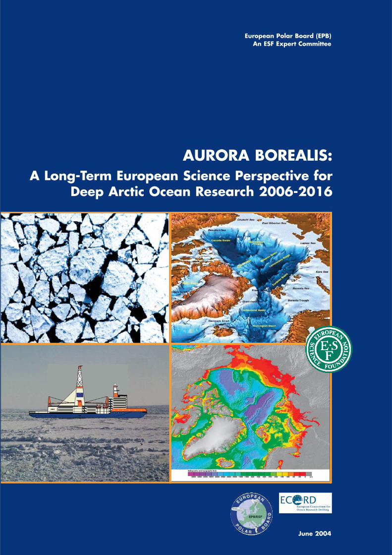
Cover pictures: Overhead image of Icebreaker Nansen Arctic Drilling Project; IBCAO Arctic Bathymetry Map; AURORA BOREALIS Research Icebreaker HSVA; IBCAO Digital Bathymetry Map.
1
AURORA BOREALIS:A Long-Term European Science Perspective forDeep Arctic Ocean Research 2006-2016
Foreword by ESF Chief Executive 3
Executive Summary 5
A Vision of European Collaboration in the Arctic Region 8
The Science Perspective – Introduction 10
PART 1The Arctic Ocean and Global Climate Change 13
The Arctic Ocean and Global Climate Change – Introduction 14
ATMOSPHERE 18
Atmospheric Forcing, Clouds and Composition of Arctic Air Masses 18
SEA ICE 19
Albedo Radiation and Atmosphere-Ice-Ocean Heat Exchange 19
The Role of Upper Ocean Processes for Extent and Thicknessof the Sea Ice Cover 20
The Dynamics of Biological Systems in a Sea Ice-Covered Arctic Ocean 21
Satellite Remote Sensing 23
Remote Sensing Validation 25
OCEAN 26
Arctic Ocean Circulation 26
Water Mass Conversions on Arctic Ocean Shelves 29
The Role of Polynias for the Water Mass Conversions of the Arctic Ocean 30
Ventilation of Arctic Ocean Waters by Shelf-Basin Exchange 31
Biodiversity in the Central Arctic Ocean 32
Interactions between Arctic Shelf, Slope and Deep Sea Bio-systems 33
Air-Sea Carbon Dioxide Flux Feedbacks in a Changing Arctic Ocean 34
Contaminants 35
PART 2Modern Geodynamics and Hydrothermalism 37
Modern Geodynamics and Hydrothermalism – Introduction 38
Vent and Seep Communities in the Arctic 39
The Deep Biosphere beneath an Ice-Covered Ocean 40
Impacts of the Siberian Shelf Seas 41
Seafloor Processes with a Geological Impact 43
Contents
2 Contents
PART 3The Arctic Ocean and its Geological History 45
The Arctic Ocean in Geological History – Introduction 46
The Formation of the Arctic Ocean Basin 46
Changes in Arctic Hydrography 47
Extreme Climates – Learning from the Past to Explain the Future 48
The Stability of the Offshore Permafrost 49
PART 4Technical Requirements for Achieving Arctic Science Goals 51
Technical Requirements for Achieving Arctic Science Goals – Introduction 52
Mission Types for the AURORA BOREALIS 52
Technical Requirements for Marine Geophysics 53
Alternative Solutions 54
Technical Requirements for a High Arctic Drilling Vessel 54
AURORA BOREALIS Conceptual Study 55
Special Technical Aspects of AURORA BOREALIS 58
Environmental Impact and Protection 60
Justification for a Technical Feasibility Study 60
PART 5Planning, Financing and Management of a Dedicated EuropeanArctic Research Platform 61
Planning, Financing and Management – Introduction 62
The Concept of the AURORA BOREALIS within EPB EUROPOLAR 62
The Management of the AURORA BOREALIS 63
Financial Options for the AURORA BOREALIS Project 63
Logistical Considerations for the AURORA BOREALIS Project 64
Ice Management System, Satellite Monitoring 65
A 10-Year Outlook for the AURORA BOREALIS 65
APPENDICES 67
I. The Development of the Science Perspective 68
II. Abstract of JEODI Arctic Site Survey Workshop 72
III. References 74
IV. Acronyms and Abbreviations 78
V. Institutional Affiliation of Contributorsto the AURORA BOREALIS Science Perspective 79
June 2004
3
Foreword
T his Science Perspective document of the
European Polar Board and ECORD has been
developed by participants from over 20 countries
throughout Europe and represents a truly pan-
European project highlighting some of the major
scientific challenges in the Arctic over the next 10
years. Scientific investigations in the central Arctic,
including an understanding of the evolution of the
climate record and structure of the Arctic Basin
through deep drilling, will be critical in the next
phase of European and international research
efforts in the Polar Regions.
The international working group involved in this
project proposes a unique and novel infrastructure:
AURORA BOREALIS, a dedicated European
research icebreaker with a deep drilling capability.
This facility would enable Europe and its
international partners to achieve an unparalleled
understanding of the dynamic processes of this
sensitive region, which is so critical for
understanding the impact of global climate change.
The forthcoming International Polar Year (IPY)
2007-08 provides an opportunity to launch such a
groundbreaking and truly European project.
Professor Bertil AnderssonChief Executive, European Science FoundationStrasbourg, 2004

4
5
Executive Summary
Polar Regions and in particular the properties of
northern and southern high latitude oceans are
currently a subject of intense scientific debate and
investigations because they are (in real time) and
have been (over historical and geological time
scales) subject to rapid and dramatic change. Polar
Regions react more rapidly and intensively to global
changes than other regions of the Earth.
Observations showing the shrinking of the Arctic
sea ice cover, potentially leading to an opening of
sea passages to the north of North America and
Eurasia en route to a “blue” Arctic Ocean, as well
the calving of giant table icebergs from the ice
shelves of Antarctica are examples of these modern
dynamics.
Until now it has not been clear whether the
profound change in all parts of the Arctic is a natural
fluctuation or is due to human activity. Since this
change is a phenomenon of decades, long time
data series of atmospheric and oceanic conditions
are needed for its understanding and prediction of
further developments. Despite the strong
seasonality of polar environmental conditions,
research in the central Arctic Ocean up to now
could essentially only be conducted during the
summer months when the Arctic Ocean is
accessible to the currently available research
icebreakers.
European nations have a particular interest in
understanding the Arctic environment with its
potential for change because highly industrialised
countries spread into high northern latitudes, and
Europe is under the steady influence of and in
exchange with the Arctic environment. In addition,
considerable living and non-living resources are
found in the Arctic Ocean, its deep sea basins and
their adjacent continental margins. Modern
research vessels capable of penetrating into the
central Arctic are few. A new state-of-the-art
research icebreaker is therefore urgently required
to fulfil the needs of European polar research and
to document a multinational European presence in
the Arctic. This new icebreaker would be conceived
as an optimised science platform from the keel up
and would enable long, international and
interdisciplinary expeditions into the central Arctic
Ocean during all seasons of the year.
Global climate models demonstrate the sensitivity
of the polar areas to changes in forcing of the ocean
climate system. The presence or absence of snow
and ice influences global heat distribution through
its effect on the albedo, and the polar oceans are
the source of dense, cold bottom waters, which
influence thermohaline circulation in the world’s
oceans. This global conveyor is a major determinant
of global climate.
In spite of the critical role of the Arctic Ocean in
climate evolution, it is the only sub-basin of the
world’s oceans that has not been sampled by the
drill-ships of the Deep Sea Drilling Project (DSDP)
or the Ocean Drilling Program (ODP), and its long-
term environmental history and tectonic structure
is therefore poorly known. This lack of data
represents one of the largest gaps of information
in modern Earth Science, also relevant for the field
of hydrocarbon exploration. Therefore, the new
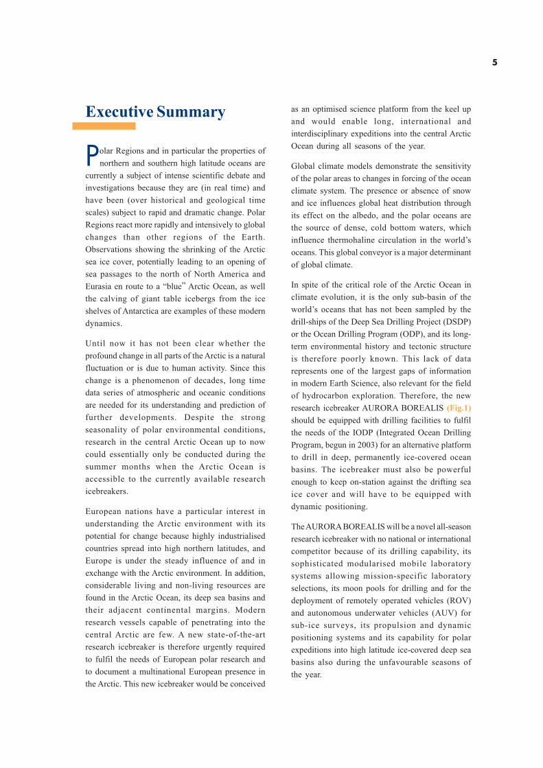
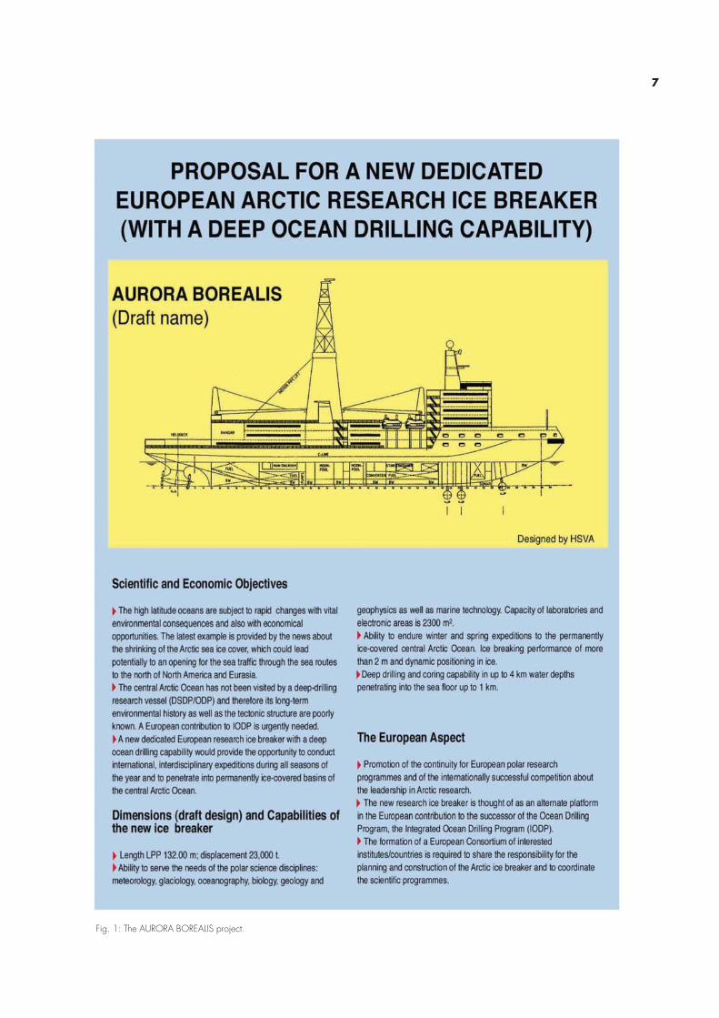
research icebreaker AURORA BOREALIS (Fig.1)
should be equipped with drilling facilities to fulfil
the needs of the IODP (Integrated Ocean Drilling
Program, begun in 2003) for an alternative platform
to drill in deep, permanently ice-covered ocean
basins. The icebreaker must also be powerful
enough to keep on-station against the drifting sea
ice cover and will have to be equipped with
dynamic positioning.
The AURORA BOREALIS will be a novel all-season
research icebreaker with no national or international
competitor because of its drilling capability, its
sophisticated modularised mobile laboratory
systems allowing mission-specific laboratory
selections, its moon pools for drilling and for the
deployment of remotely operated vehicles (ROV)
and autonomous underwater vehicles (AUV) for
sub-ice surveys, its propulsion and dynamic
positioning systems and its capability for polar
expeditions into high latitude ice-covered deep sea
basins also during the unfavourable seasons of
the year.
6
An effective use of the new research icebreaker
requires the formation of a consortium of European
countries and their polar research institutions to
ensure a high quality of science and efficient
employment of the research vessel during all
seasons of the year. Extensive and well-developed
Arctic research programmes exist in several
European countries, particularly in the
Scandinavian countries, Russia and Germany.
Different organisations or working groups, with
rather diverse structures and domestic impact, exist
in each individual country. The construction of
AURORA BOREALIS as a joint European research
icebreaker would result in a considerable
commitment of the participating nations to co-
ordinate and expand their polar research
programmes in order to operate this facility
continuously and with the necessary efficiency. If
AURORA BOREALIS is eventually established as
a European research icebreaker for the Arctic,
European polar research will be strengthened; and
Europe will be able to contribute to meeting the
Arctic drilling challenge within IODP.
However, from a long-term perspective, the
AURORA BOREALIS could also be used to
address Antarctic research targets, both in its mode
as a regular research vessel as well as a polar drill-
ship. The international nature of the Arctic research
perspective and of IODP should also be open to
participation by non-European countries.
Ideas for a new research icebreaker for the Arctic
have been developed by several groups. The
sketch below demonstrates the initial HSVA design
of the AURORA BOREALIS:
Executive Summary
7
Fig. 1: The AURORA BOREALIS project.
8
A Vision of European
Collaboration in the
Arctic Region
…The critical role of the Arctic inregulating and driving the globalclimate system is one that requireselucidation in all its complexities. Thisis necessary to predict futureenvironmental changes and determinestrategies that must be adopted bynations to protect the functioning ofthe Earth system...
European nations have a particular interest in
understanding the Arctic environment with its
inherent sensitivity to change. The Arctic Ocean
contains considerable living and non-living
resources. The interactions and effects of human
influence must be understood in order to develop
adequate means of protection and potential
scientific and economic use of this unique
environment. The development of a dedicated
European research platform icebreaker will enable
the study of physical, chemical and biological
processes in the Arctic regions during all seasons
of the year and will promote internationally
integrated and multidisciplinary science
programmes based on a unique large research
facility. The AURORA BOREALIS project is a core
element of the European Polar Board’s strategic
framework EUROPOLAR and is a concept which
enables strengthening, expansion and commitment
to the organisation and implementation of
European polar research.
Global climate change amplified in the high Arctic
has a profound effect on circumArctic populations.
This is particularly seen in the social and economic
damage arising from more frequent climate-induced
extreme events. Anthropogenic feedbacks into the
cryosphere-atmosphere-ocean system need to be
investigated and evaluated with much greater
precision. A dedicated European scientific research
platform will significantly contribute towards
observation and monitoring of changes in the
environment at high latitudes. Polar marine research
over the next 10 to 15 years will concentrate on the
long-term natural variability within the ecosystems
of the Arctic Ocean. This will focus on the
feedbacks between atmosphere, sea ice, ocean and
biological systems. In particular the propagation
of anomalies through the system is used to
understand the pelagic ecosystems during the
different seasons, the response of planktonic
systems and benthic biota to variations in
sedimentation and river supply as well the
distribution pattern of anthropogenic contaminants
in the Arctic.
Climate models demonstrate the sensitivity of the
Arctic Basin to changes in forcing of the ocean
climate system. Snow and ice cover influence global
heat distribution and the polar oceans are the source
of dense, cold bottom waters that influence
thermohaline circulation in the world’s oceans. The
global conveyor is a major determinant of climate.
In spite of the critical role of the Arctic Ocean for
climate evolution in the Northern Hemisphere, it is
the only sub-basin of the world’s oceans that has
not been sampled by any scientific drill–ship, and
its long-term paleoenvironmental history and
tectonic structure is poorly known. This lack of
data represents one of the largest gaps of
information in modern Earth Science. Drilling and
sampling of the Arctic Basin will be one of the major
scientific and technological challenges of this
decade and one in which Europe will play a key
role. It could form a major European contribution
to IODP (Integrated Ocean Drilling Program) and
the AURORA BOREALIS could be considered one
of the premier European alternative platforms.
The main strength of the AURORA BOREALIS
project is that it is a unique research platform
providing the solution to several multidisciplinary
scientific demands. The concept provides a
pathway to the development of a European
Research Area in Arctic system science and is at
the heart of European cooperation in polar
scientific research and operational capabilities. The
A Vision of European Collaboration in the Arctic Region
9
implementation of a European Arctic Observing
System using AURORA BOREALIS will open up
long-term perspectives to international
programmes and enable greatly enhanced
knowledge and sound policy advice to be given to
governments on the status of changes to the global
environment.
This Science Perspective will provide a basis for
future scientific investigations of the High Arctic
and define a decadal forward-looking strategy for
European cooperation in Arctic science.
The present Science Perspective developed by the
European Polar Board has mainly an Arctic focus
because sufficient research capabilities will be
available in Antarctic waters for the coming decade.
However, considering the bipolar research interest
of many of the European and polar research
programmes, it is clear that the AURORA
BOREALIS project also has the ability to conduct
all-season research and deep sea drilling activities
in the ice-infested waters of the Southern Ocean.
The annual transit of research icebreakers between
Arctic and Antarctic waters is not an efficient
mechanism. Once a decade of dedicated research
has been carried out in the Arctic Ocean, an
assessment will be made of the scientific capability
of the AURORA BOREALIS for mission-specific
purposes in the Southern Ocean, and whether it
could provide an efficient and modern research
platform for those waters.
June 2004
Jörn Thiede
Chairman of the AURORA BOREALIS InternationalScience Planning Committee and former Chairmanof the European Polar Board of ESF with20 member nations
10
The Science Perspective -
Introduction
The AURORA BOREALIS project addresses two
scientific communities which in part overlap and in
part have divergent interests. The first one is the
general polar science community, which requires a
research vessel for conducting its field and sea
work throughout all seasons of the year, hence
with wide scientific perspectives. The other is the
deep sea drilling community, which would use the
ship mainly during the summer months to study
the structure and properties of the oceanic crust
and the history of the oceanic depositional
environments that can be deduced from the oceanic
sediment cover. This has never been carried out in
a systematic way in the permanently ice-infested
waters of the Arctic, whereas around Antarctica
substantial progress has been achieved by using
the drilling platforms of the Deep Sea Drilling
Project (DSDP) and the Ocean Drilling Program
(ODP) during the ice-free seasons and by using a
small drill rig from the landfast sea ice very close to
shore (CRP, Cape Roberts Project).
As outlined later, AURORA BOREALIS is currently
thought of as an Arctic research vessel with a deep
drilling capability. In the long term, however, it also
has an Antarctic perspective because neither the
CRP-tools nor the conventional drilling vessels,
which cannot enter ice-infested waters, are able to
cover all desirable drilling locations off Antarctica.
Many of these locations have not so far been
investigated, mainly due to the lack of a suitable
ice-capable drilling platform. These scientific
targets will now receive renewed attention.
Europe requires new and additional research
capabilities to venture into the deep, permanently
ice-covered Arctic Ocean. The novel research
vessel AURORA BOREALIS will provide such a
facility and it should be planned as a European
infrastructure unit. It has to be supported by a core
group of European countries with relevant research
interests; for example, problems in basic research
or highly applied research such as fossil
hydrocarbon exploration.
From the romantic and heroic times of the early
explorers, science in the Polar Regions has evolved
into a modern, quantitative branch of the natural
sciences, which employs large groups of
researchers and sophisticated, expensive
instrumentation contributing indispensable data for
better understanding the extreme habitats of the
Polar Regions as well as their impact on the global
environment. The fact that much of the necessary
data can be collected only by dedicated research
vessels, from permanently manned stations or
during expeditions involving many different
disciplines and substantial logistic efforts, has
resulted in complex interdisciplinary experiments,
which can be co-ordinated only under the
framework of close international cooperation.
Most of today’s scientific polar research problems
are thematically oriented and require inter- and
multidisciplinary cooperation. They comprise
elements of fieldwork, of modelling and of
application and a close cooperation with many
national and international partners. Hence, this
document contains a comprehensive, though not
necessarily complete, science perspective for
Arctic and, to a lesser degree, also Antarctic
research. However, it must be clear, that planning a
large and novel research icebreaker results in a
scientific programme that is focused on research
disciplines and activities that require a ship with
the capability of year-round operations in the
central Arctic.
The Science Perspective is organised following a
thematic scheme, but also identifies the main
technical, managerial and organisational aspects
of the AURORA BOREALIS project, whose
developments have to be science driven. They have
not been developed to the same depth as the
science plan. In particular, the details of technical
planning will require much further refinement, which
cannot be provided by scientists, but which will
have to come through a separate technical design
study. Managerial, financial and organisational
structures for running the ship are outlined in a
preliminary form. Detailed management concepts
need the input of the international science
community and relevant agencies committed to the
AURORA BOREALIS concept.
The Science Perspective – Introduction
11
High latitude polar oceans and land areas have a
high impact on the global environment; they
actually control large segments of the global
environment and they can be considered drivers
of global climate change. This holds true in
particular for Europe and for the Arctic Ocean
because the interplay between the North Atlantic
Ocean and the Arctic Ocean results in a large
anomaly of the climatic zonation of the Northern
Hemisphere. Hence, European nations have an all-
important interest in understanding the Arctic
Ocean, its properties and their natural variability
as well as their interaction with the adjacent
temperate ocean basins. Many European nations
therefore support polar research not only in
Antarctica but in the Arctic as well and it is indeed
a special characteristic of many of the European
polar research programmes to have a bipolar
perspective.
The urgency of opinions and decisions about the
future of the global environment has resulted in
large polar research efforts in many nations. At the
present time the perspectives of polar research for
the coming decades in the Northern and Southern
Hemisphere high latitude regions are evaluated,
defined and strengthened in many ways.
The science perspective of the AURORA
BOREALIS presents a strategy of deploying a
powerful tool for carrying out research in the central
Arctic Ocean throughout the entire year for a
decade or more in this poorly known ocean basin.
All indications point to a time of rapid change in
the Arctic, and some scientists speculate about a
“ blue ” Arctic Ocean in 50 years from now. The
coming decade will be a critical phase in this
development especially in the light of the proposed
International Polar Year 2007-08 as a platform for
an enhanced focus on the Polar Regions.
The central deep sea basins of the Arctic Ocean
have yet to be visited by a scientific drill-ship and
it is henceforth paramount, under the auspices of
IODP, to deploy platforms to solve the following
mysteries:
. the plate tectonic origin of the Arctic Ocean
. the nature of the major structural highs as well
of the oceanic crust on the other parts of the
Arctic Ocean
. to probe for long sediment cores of undisturbed
stratigraphic sequences recording the
properties of a warm Arctic Ocean prior to the
onset of the Northern Hemisphere glaciation
. the traces of the earliest ice covers sometime
during the Miocene
. the variability of the glacial and interglacial
climate system during the latest part of the
Cenozoic.
The technical requirements necessary for the
intended research require a large and powerful
research vessel that can endure very unfavourable
weather and ice situations, is able to position itself
dynamically against a drifting sea ice cover mainly
without the assistance of other icebreakers and
which is strong enough to hold its position
precisely enough to be able to carry out deep sea
drilling. It also calls for the routine deployment of
novel, strong propulsion systems as well as for
the development of a large icebreaker with one to
two moon pools for the deployment of the drilling
instrumentation, ROVs and AUVs as well as
deployment of sensitive instrumentation during
very unfavourable weather conditions. The dual-
purpose research vessel will require flexible
laboratory arrangements and it is intended to
develop a system of modularised and containerised
labs, which can be designed and modified
according to the needs of a variety of missions.
The AURORA BOREALIS would be the first true
European research vessel. A decision to build and
run it will require large and well-coordinated efforts
of the interested countries. With a view to being
part of IODP and of the multinational polar research
programme, it will not only lead to harmonisation
of the polar research programmes but it will
encourage the participating nations to look jointly
for perspectives in polar research resulting in
synergies and efforts hitherto unknown. It will
enable data collection and probing of the
environment at times when the Polar Regions have
never been visited before (mainly during the harsh
12
late autumn, winter and early spring seasons) and will
allow European nations to maintain their leading
position in Arctic and Antarctic research.
At the same time the AURORA BOREALIS can be
considered as a floating laboratory bringing
together a sizeable scientific community during an
uninterrupted series of multidisciplinary/
interdisciplinary and multinational/international
expeditions. It can indeed be considered a floating
university and it will be spacious enough to allow
the indigenous people of the Arctic–rim countries
to contribute and participate in this research, which
will collect data and gain insight into the
environment on which they depend.
The AURORA BOREALIS will be globally the most
advanced research platform with state-of-the-art
technology for polar research. With its all-season
capability it will provide a platform for tackling major
scientific challenges, which hitherto has not been
possible. It would be a floating European university
in polar sciences. It would promote the idea of the
European Research Area and it would result in
substantial competitive advantages. In addition, it
would help in the collection of data to advance the
definition of the continental margins from an EEZ
point of view (and it would increase safety in Arctic
operations). Besides basic research, it would
provide an opportunity to look for non-living Arctic
resources such as gas hydrates or other fossil
hydrocarbons. It would also give the European
nations an advantage in the planning, construction
and deployment of large icebreakers in the Arctic,
which seems to be developing into one of the most
important regions in the Northern Hemisphere.
The Science Perspective – Introduction
13
The Arctic Ocean
and Global Climate
Change – Atmosphere,
Sea Ice & Ocean
Part 1
Assimilated GOME total ozone30-11-99 12h
KNMI/ESA
<150 175 200 225 250 275 300 325 350 375 400 425 450 475 >500 DU
no data
14
The Arctic Ocean and
Global Climate Change –
Introduction
The temperature increase in the Arcticduring the last 50 years is three timeslarger than the global average andcan be taken as an indicator of globalchange in the Arctic. The Arcticatmosphere-sea ice-ocean systemreacts to and modifies these changes.Marine biota, CO2-fluxes and humanliving conditions are affected.Improved understanding of thissystem is needed to distinguishbetween the natural and anthropogenicvariations and to build up predictivecapabilities.
The coupled atmosphere-sea ice-ocean system in
the Arctic represents an integral part of the global
climate system by its effect on the heat balance
which is strongly affected by atmospheric and sea
ice conditions in the Arctic as well as by the
formation of dense water masses which spill over
the sills into the North Atlantic Ocean and feed
into the global overturning circulation (Houghton
et al., 2001). Sea ice and ocean waters give home to
a variety of biota, which are supplied through river
and aeolian input with materials (and nutrients) from
the land. The vertical flux of dissolved and
particular organic and inorganic matters into the
deep sea provides a basis of benthic life (Fig. 2).
The Arctic Mediterranean Sea comprises the Arctic
Ocean with the adjacent shelf seas and the Nordic
Seas (Aagaard et al., 1985). It consists of a series
of ocean basins separated by ridges, and its internal
circulation is to a large extent determined by the
basin structure (Aagaard et al., 1985; Aagaard and
Carmack, 1994; Rudels, 2001) (Fig. 3). Relatively
warm and saline water enters the Nordic Seas from
the North Atlantic and is advected through the
Fram Strait and the Barents Sea into the Arctic
Ocean (Rudels et al., 1994). The Atlantic water re-
circulates along different paths in the Arctic
Mediterranean, undergoing extensive modification
(Rudels et al., 1999a). River runoff from the
continents adds a significant volume of freshwater,
Fig. 2: Factors controlling the Arctic Ocean environment and sedimentation along the Eurasian continental margins and in the adjacentdeep sea with implications for ecosystems.
Part 1The Arctic Ocean and Global Climate Change – Atmosphere, Sea Ice & Ocean
15
and water of lower salinity is supplied by the Pacific
through the Bering Strait (Carmack, 2000). Due to
the large-scale sea level inclination there is a net
transport of low salinity water from the Pacific to
the Atlantic which, in spite of its comparatively
small volume, constitutes a major control in the
global freshwater cycle (Jones et al., 1998). The
severe climate, with winter temperatures far below
0oC and the strong stratification in the upper part
of the water column caused by the freshwater input
leads to ice formation and to the maintenance of a
seasonally variable, but currently perennial ice
cover in the Arctic Ocean (Wadhams, 2000).
The circulation in the Arctic Mediterranean is
driven by wind and by thermohaline processes.
The air pressure distribution is basically
determined by a high-pressure system over the
Beaufort Sea and a low-pressure system over the
Nordic Seas leading to an anticyclonic atmospheric
circulation pattern over the Arctic Ocean
(Przybylak, 2003), which induces a large-scale
Fig. 3: Schematic circulation of upper layer water (thick arrows) and intermediate water (thin arrows). The flow of Atlantic water followsthe red arrows, the return of freshwater from the Pacific Ocean to the Atlantic Ocean the dark blue arrows originating at the BeringStrait. The straight arrows represent the mouths of the major rivers (Anderson, 2002).
oceanic circulation (Proshutinsky and Johnson,
1997). The seasonally varying ice cover responds
to the winds and the ocean currents, and the
anticyclonic circulation of the Beaufort gyre and a
less developed cyclonic counterpart in the
European Arctic feed into the Transpolar Drift,
which provides the major export of sea ice and low
salinity upper waters through the Fram Strait.
Upper, less saline, water masses also exit the Arctic
Ocean through the Canadian Arctic Archipelago
into the Labrador Sea.
The Fram Strait is the only deep connection
between the Arctic Ocean and the Nordic Seas,
where exchanges of intermediate and deep waters
take place (Rudels et al., 2000; Fahrbach et al., 2001).
The denser water masses eventually leave the
Arctic Mediterranean as overflow waters and
supply the source waters for the North Atlantic
Deep Water, which plays a significant role in the
global overturning circulation (Dickson et al., 2001).
Arctic Ocean Circulation
16
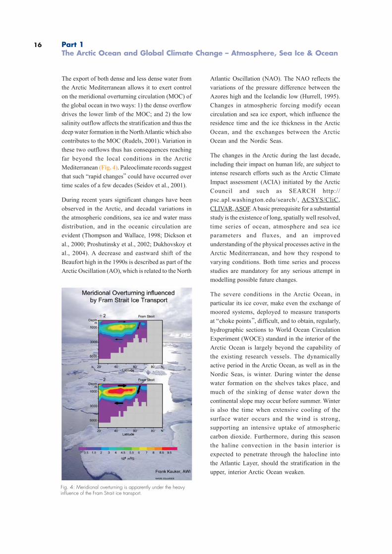
The export of both dense and less dense water from
the Arctic Mediterranean allows it to exert control
on the meridional overturning circulation (MOC) of
the global ocean in two ways: 1) the dense overflow
drives the lower limb of the MOC; and 2) the low
salinity outflow affects the stratification and thus the
deep water formation in the North Atlantic which also
contributes to the MOC (Rudels, 2001). Variation in
these two outflows thus has consequences reaching
far beyond the local conditions in the Arctic
Mediterranean (Fig. 4). Paleoclimate records suggest
that such “rapid changes” could have occurred over
time scales of a few decades (Seidov et al., 2001).
During recent years significant changes have been
observed in the Arctic, and decadal variations in
the atmospheric conditions, sea ice and water mass
distribution, and in the oceanic circulation are
evident (Thompson and Wallace, 1998; Dickson et
al., 2000; Proshutinsky et al., 2002; Dukhovskoy et
al., 2004). A decrease and eastward shift of the
Beaufort high in the 1990s is described as part of the
Arctic Oscillation (AO), which is related to the North
Atlantic Oscillation (NAO). The NAO reflects the
variations of the pressure difference between the
Azores high and the Icelandic low (Hurrell, 1995).
Changes in atmospheric forcing modify ocean
circulation and sea ice export, which influence the
residence time and the ice thickness in the Arctic
Ocean, and the exchanges between the Arctic
Ocean and the Nordic Seas.
The changes in the Arctic during the last decade,
including their impact on human life, are subject to
intense research efforts such as the Arctic Climate
Impact assessment (ACIA) initiated by the Arctic
Council and such as SEARCH http://
psc.apl.washington.edu/search/, ACSYS/CliC,
CLIVAR, ASOF. A basic prerequisite for a substantial
study is the existence of long, spatially well resolved,
time series of ocean, atmosphere and sea ice
parameters and fluxes, and an improved
understanding of the physical processes active in the
Arctic Mediterranean, and how they respond to
varying conditions. Both time series and process
studies are mandatory for any serious attempt in
modelling possible future changes.
The severe conditions in the Arctic Ocean, in
particular its ice cover, make even the exchange of
moored systems, deployed to measure transports
at “choke points”, difficult, and to obtain, regularly,
hydrographic sections to World Ocean Circulation
Experiment (WOCE) standard in the interior of the
Arctic Ocean is largely beyond the capability of
the existing research vessels. The dynamically
active period in the Arctic Ocean, as well as in the
Nordic Seas, is winter. During winter the dense
water formation on the shelves takes place, and
much of the sinking of dense water down the
continental slope may occur before summer. Winter
is also the time when extensive cooling of the
surface water occurs and the wind is strong,
supporting an intensive uptake of atmospheric
carbon dioxide. Furthermore, during this season
the haline convection in the basin interior is
expected to penetrate through the halocline into
the Atlantic Layer, should the stratification in the
upper, interior Arctic Ocean weaken.
Fig. 4: Meridional overturning is apparently under the heavyinfluence of the Fram Strait ice transport.
Part 1The Arctic Ocean and Global Climate Change – Atmosphere, Sea Ice & Ocean
17
To study these processes when they are active, not
just record traces of their presence, an icebreaker of
exceptional capabilities is required, and not just for
one winter but for extended periods. The Arctic Ocean
is large and what are the most active and important
areas have not yet been determined. The relevant
investigations are strengthened by multidisciplinary
studies, including chemical tracer work with the need
to sample waters during the winter season. This
sampling must be performed under conditions that
avoid the samples freezing; for example. through a
moon pool.
Biological studies in the Arctic Ocean aim on seasonal
aspects of sea ice and pelagic biota at ice- covered
high latitudes. Investigations of the deep Arctic Ocean
will include:
. investigations on hydrothermal vent
communities along the Gakkel Ridge
. studies on bacterial communities inhabiting in
the deep biosphere of ocean basins
characterised by low productivity
. research on cold seeps along the Eurasian
continental slope
. the installation of long-term observatories at
key locations in the ice-covered Arctic Ocean.
The majority of past expeditions to the Arctic were
conducted during the summer season. Therefore,
a sound database on the biology of organisms
inhabiting the sea ice, the water column or the
seafloor is available for many regions of the Arctic
Ocean and its surrounding shelf seas during this
period of a year. In contrast there are only few and
randomly scattered samples taken in the central
Arctic Ocean and very little information is available
on seasonal aspects such as reproductive cycles,
overwintering strategies and metabolic adaptations
during winter. Additionally, we have only limited
information about species composition and
distribution in the three marine sub-systems
(cryosphere, pelagic and benthic realm) for the
central Arctic. Any profound discussion about
latitudinal gradients in marine biodiversity needs
more systematic sampling, as well as the
identification of shifts in distribution patterns of
species due to any effects of global change.
The Arctic Ocean system also plays an important role
in taking up carbon dioxide from the atmosphere
(Anderson and Kaltin, 2001). The mechanisms
controlling this uptake is twofold: the cooling of the
surface water increases the solubility of carbon
dioxide, and the extensive primary production in
some regions decreases the partial pressure of
carbon dioxide of the water surface. The
combination of extensive uptake of atmospheric
carbon dioxide and deep-water production makes
the area a significant sink of anthropogenic carbon
dioxide.
The changes observed during the last decades
have a visible impact on natural conditions and on
human life in the Arctic and will have dramatic
consequences for the socio-economic conditions
in the Arctic which will be clearly noticeable in NW
Europe (McCarthy et al., 2001). Ship traffic through
the Northern Sea Route will flourish with the
reduction of transport costs within northern Europe
and between Europe and Asia and improving
accessibility of wide areas in the European Arctic
and beyond. Exploitation of natural resources in
the Arctic Ocean will be greatly facilitated in the
case of further warming and sea ice retreat.
However, it is still not clear that changes in the
Arctic are part of a natural variability or if they are
the consequence of human impact. Neither can it
be said whether the trend will continue or if we are
faced with a decadal fluctuation. There is an urgent
need to understand change in order to predict
further developments. The warming period in the
Arctic during the 1920s and 1930s gave rise to
similar expectations, and a rapid subsequently
cooling endangered hundreds of ships in the late
1930s. Therefore there is a fundamental need for a
substantial understanding of climate change which
requires the availability of long time series of ocean,
atmosphere and sea ice studies.
18
Atmosphere
Atmospheric Forcing, Clouds andComposition of Arctic Air Masses
The atmospheric circulation andradiation properties as clouds andaerosols are major elements of theglobal heat budget and have to beincluded realistically in global climatemodels. Arctic data are urgentlyneeded.
The Arctic atmospheric circulation and the
interaction between atmosphere, ice and ocean form
the physical interactive processes controlling the
climate in the Polar Regions, extending their
reflections south to sub-polar regions. Significant
changes in atmospheric parameters become
obvious (Serreze et al., 2000; Comiso, 2003). In terms
of global climate change the importance of the
Arctic atmospheric circulation and atmosphere
ocean interaction may be compared with the crucial
role of ocean convection and overturning of the
Arctic waters, as driving forces for the thermohaline
circulation and hydrography of the world ocean.
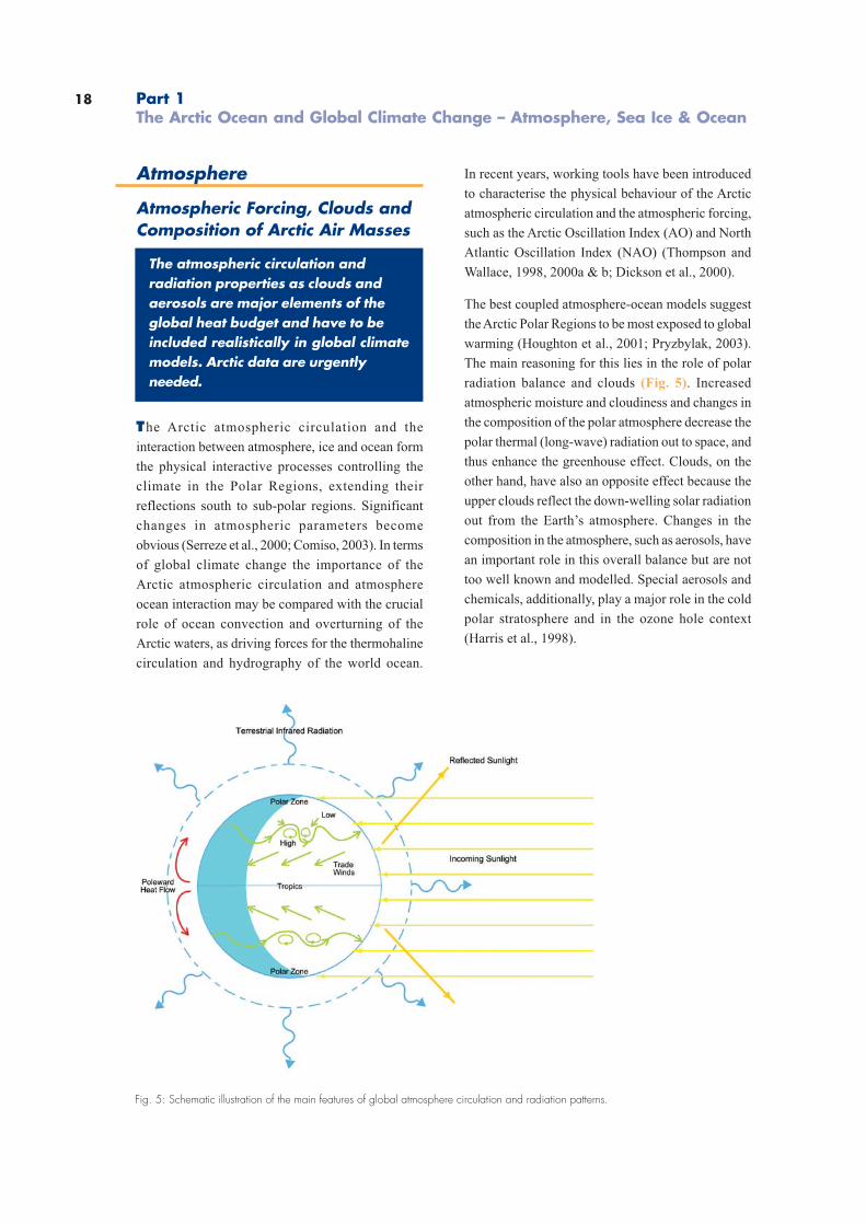
In recent years, working tools have been introduced
to characterise the physical behaviour of the Arctic
atmospheric circulation and the atmospheric forcing,
such as the Arctic Oscillation Index (AO) and North
Atlantic Oscillation Index (NAO) (Thompson and
Wallace, 1998, 2000a & b; Dickson et al., 2000).
The best coupled atmosphere-ocean models suggest
the Arctic Polar Regions to be most exposed to global
warming (Houghton et al., 2001; Pryzbylak, 2003).
The main reasoning for this lies in the role of polar
radiation balance and clouds (Fig. 5). Increased
atmospheric moisture and cloudiness and changes in
the composition of the polar atmosphere decrease the
polar thermal (long-wave) radiation out to space, and
thus enhance the greenhouse effect. Clouds, on the
other hand, have also an opposite effect because the
upper clouds reflect the down-welling solar radiation
out from the Earth’s atmosphere. Changes in the
composition in the atmosphere, such as aerosols, have
an important role in this overall balance but are not
too well known and modelled. Special aerosols and
chemicals, additionally, play a major role in the cold
polar stratosphere and in the ozone hole context
(Harris et al., 1998).
Part 1The Arctic Ocean and Global Climate Change – Atmosphere, Sea Ice & Ocean
Fig. 5: Schematic illustration of the main features of global atmosphere circulation and radiation patterns.
19
Observations of clouds and composition of the
polar atmosphere can be carried out by remote
sensing and special automatic stations. Satellite
methods have good spatial and temporal coverage.
However, most of the quantities wanted are derived
by inverse methods and remain too inaccurate
because of incomplete ground check and validation.
Therefore, in-situ observations and vertical
soundings of the physical and chemical
composition and mechanisms of the atmosphere
over the Arctic Ocean are necessary in a sustained
manner. In practice, those observations can be
made only from mobile marine platforms. Because
observations and monitoring are necessary over
all seasons and regions, a strong ice-going polar
ice research vessel is needed as a quasi-permanent
platform.
Sea Ice
Albedo Radiation and Atmosphere-Ice-Ocean Heat Exchange
Sea ice and albedo play a central rolein the Arctic Ocean heat budgetbecause sea ice limits the heat exchangebetween ocean and atmosphere andthe albedo determines the reflection ofincoming radiation.
The sea ice and albedo of sea ice play the central
role in the ocean-ice-atmosphere interaction and
heat exchange (Eicken and Lemke, 2001). A high
summertime albedo, reflecting the most part of the
global radiation back to the atmosphere, is the
precondition to formation of multiyear sea ice
(Maykut and Untersteiner, 1971). On the other hand,
even slight changes in the Arctic albedo may
change the sea ice conditions, atmosphere-ocean
interaction and heat exchange drastically. Actually,
modelling and estimation of the polar albedo
remains one of the most crucial issues for predicting
scenarios of global climate change. Unfortunately,
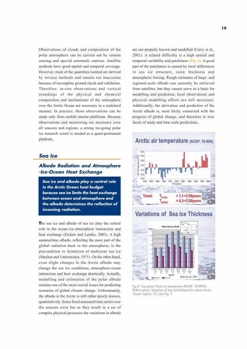
the albedo in the Arctic is still rather poorly known,
quantitatively. Some fixed measured time series over
the seasons exist but as they result in a set of
complex physical processes the variations in albedo
are not properly known and modelled (Curry et al.,
2001). A related difficulty is a high spatial and
temporal variability and patchiness (Fig. 6). A good
part of the patchiness is caused by local differences
in sea ice structure, snow thickness and
atmospheric forcing. Rough estimates of large- and
regional-scale albedo can currently be retrieved
from satellites, but they cannot serve as a basis for
modelling and prediction; local observations and
physical modelling efforts are still necessary.
Additionally, the derivation and prediction of the
Arctic albedo is, most likely, connected with the
progress of global change, and therefore to new
facets of study and time scale predictions.
Fig.6: Top panel: Arctic air temperature (NCEP: 70-90N).Bottom panel: Variations of sea ice thickness for various ArcticOcean regions. Cf. also Fig. 7.
20
During recent years, retreat and thinning of the
Arctic sea ice has been reported (Vinnikov et al.,
1999; Rothrock et al., 1999; Wadhams and Davis,
2000; Comiso, 2002; Rothrock et al., 2003). In those
reports, the changes have been (surprisingly) rather
distinct. However, the characteristics of the
regional distribution of time-scale variations make
it difficult to distinguish between natural variability
in decadal time scales and the potentially human-
caused climate change. Only sustained
measurements will allow convincing conclusions.
However, the example below should give an idea
of the importance of accurate and realistic
information of the Arctic sea ice cover.
The studies referred in Houghton et al. (2001)
conclude the summertime Arctic sea ice extent to
have been decreased from the late 1950s to l990s
by 10-15%. Accordingly, if we assume the snow-
covered Arctic sea ice albedo to be of the order of
0.8, the above decrease in the sea ice extent would
mean an order of 30% more short-wave radiation
gain in spring and summer in the whole Arctic
Ocean, compared with the previous conditions.
Accurate determination of structure and
concentration of sea ice in the broken Arctic ice
fields is necessary for modelling sea ice dynamics,
with regard to energy exchange between the ocean
and the atmosphere. We know that the turbulent
ocean-atmosphere exchange of heat and moisture
from leads and cracks is the most intense
(Launiainen and Vihma, 1994). Accordingly, fluxes
via leads and cracks of 5% of the area are
comparable to those from the sea ice-covered areas.
Therefore, the sea ice concentration should be
determined more accurately than is currently carried
out using the best satellite image-derived
algorithms.
The necessary field studies for better investigation
and modelling of albedo, sea ice structure and
concentration, snow properties and ocean-ice-
atmosphere exchange can only be made from
marine/sea ice platforms, available all year round
and able to operate in large areas.
Part 1The Arctic Ocean and Global Climate Change – Atmosphere, Sea Ice & Ocean
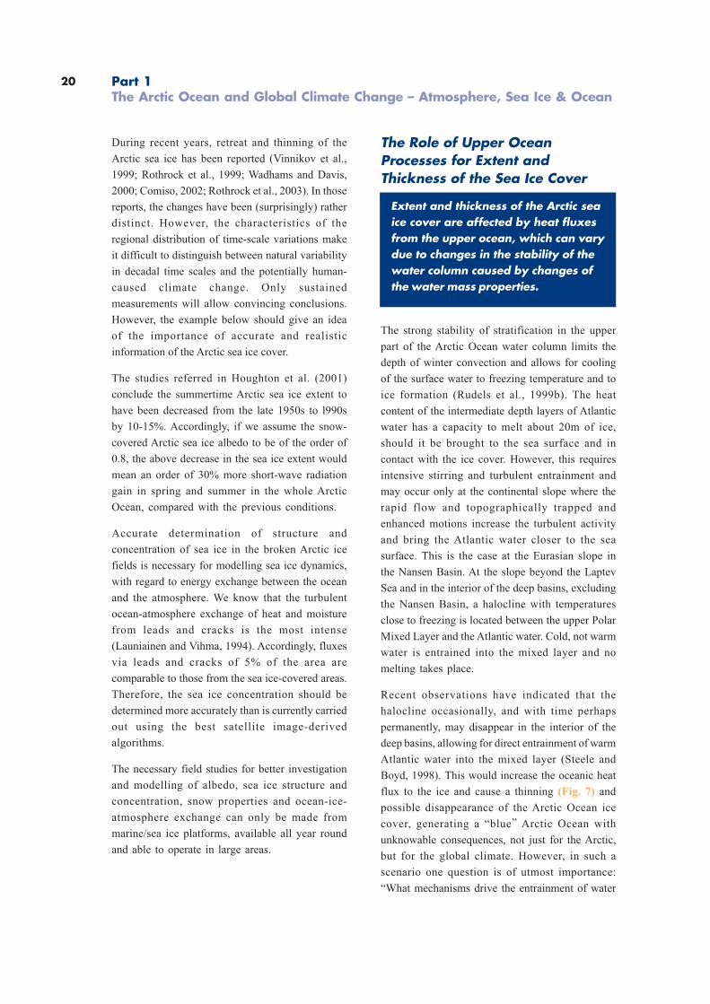
The Role of Upper OceanProcesses for Extent andThickness of the Sea Ice Cover
Extent and thickness of the Arctic seaice cover are affected by heat fluxesfrom the upper ocean, which can varydue to changes in the stability of thewater column caused by changes ofthe water mass properties.
The strong stability of stratification in the upper
part of the Arctic Ocean water column limits the
depth of winter convection and allows for cooling
of the surface water to freezing temperature and to
ice formation (Rudels et al., 1999b). The heat
content of the intermediate depth layers of Atlantic
water has a capacity to melt about 20m of ice,
should it be brought to the sea surface and in
contact with the ice cover. However, this requires
intensive stirring and turbulent entrainment and
may occur only at the continental slope where the
rapid flow and topographically trapped and
enhanced motions increase the turbulent activity
and bring the Atlantic water closer to the sea
surface. This is the case at the Eurasian slope in
the Nansen Basin. At the slope beyond the Laptev
Sea and in the interior of the deep basins, excluding
the Nansen Basin, a halocline with temperatures
close to freezing is located between the upper Polar
Mixed Layer and the Atlantic water. Cold, not warm
water is entrained into the mixed layer and no
melting takes place.
Recent observations have indicated that the
halocline occasionally, and with time perhaps
permanently, may disappear in the interior of the
deep basins, allowing for direct entrainment of warm
Atlantic water into the mixed layer (Steele and
Boyd, 1998). This would increase the oceanic heat
flux to the ice and cause a thinning (Fig. 7) and
possible disappearance of the Arctic Ocean ice
cover, generating a “blue” Arctic Ocean with
unknowable consequences, not just for the Arctic,
but for the global climate. However, in such a
scenario one question is of utmost importance:
“What mechanisms drive the entrainment of water
21
from below into the mixed layer?” Is the necessary
turbulence in the mixed layer generated by the
mechanical stirring caused by wind and drifting
ice, or is it created by the haline convection induced
by freezing and brine release during winter?
Regardless of process, the winter is the only period
when entrainment into the Polar Mixed Layer
occurs, since a low salinity melt water layer is
present at the surface in summer (Rudels, 1999b,
2001). No significant atmospheric cooling is present
and the stability in the upper part of the Polar Mixed
Layer is too strong for wind-generated turbulence
to reach the lower boundary of the Polar Mixed
Layer and no entrainment takes place. In winter
the stabilising melt water layer is removed by
freezing and entrainment of underlying water into
the Polar Mixed Layer becomes possible. In the
absence of a cold, intermediate halocline
entrainment, warm Atlantic water would reduce the
ice formation and thus also reduce the release of
salt. The decrease in stability at the lower boundary
of the mixed layer during winter then becomes
smaller than when cold water is entrained.
Fig. 7: Difference in September ice thickness: 1993 / 96 / 97minus 1958/ 60/ 62/ 70/ 76.(Holloway and Sou, 2002)
The strength of the entrainment depends inversely
upon the stability at the base of the mixed layer,
and the interactions with the ice cover, induced by
entrainment of warm water, provides a negative
feedback that acts to reduce the entrainment.
In the special case when the turbulence driving
the Atlantic water into the mixed layer is generated
by convection, strong entrainment of warm water
could temporarily shut down the ice formation and
thus the convection, causing the turbulence in the
mixed layer to weaken and the entrainment to
disappear. Furthermore, convection is a poor mixing
mechanism, and much of the cooling of the Atlantic
water could actually occur at the lower boundary
of the mixed layer when dense, haline plumes
penetrate into the underlying warmer Atlantic layer.
The heat of the Atlantic water is then not brought
to the surface to supply heat to the atmosphere
and to melt ice, but is used to heat the cold plumes
within the water column.
To understand the complex interactions between
sea ice and the underlying waters, observations
from numerous sites in the interior of the Arctic
Ocean during the active winter season are required.
Observations that best can be made from an
icebreaking vessel, either directly or from the ice
with the ship as a base.
The Dynamics of BiologicalSystems in a Sea Ice-CoveredArctic Ocean
Sea ice provides a unique habitat fora variety of organisms, which canserve as a food source or seeding stockfor marine life on higher trophic levels.
The first trophic pulse in the Arctic Ocean is
represented by phytoplankton primary production,
which varies considerably and is described as
being dependent upon the day length, the
hydrological, hydrochemical and biological factors,
as well as the cover and thickness of sea ice.
To improve our understanding of sea ice biota, long-
term observations on the development of sea ice
22
communities are needed. For better estimates of
the production of the sea ice (sympagic) floral and
faunal data are are needed for late autumn, the
complete winter and early spring. These are critical
seasons since we have no idea of how long the
growing season is for sympagic organisms. To
obtain quantitative data, stationary ship time at
selected flows for 2-3 weeks at a time has to be
allocated during those critical seasons.
It is still not clear if sympagic organisms serve as
food source for pelagic organisms during
wintertime, as was found to be the case for Antarctic
sympagic algae. The Antarctic krill (Euphausia
superba) depends during wintertime on the
sympagic production. Similarly the Arctic cod
(Boreogadus saida) may use sympagic amphipods
in the same way.
There is growing evidence that sympagic algae
serve as inoculum for the initiation of the spring
bloom in Antarctic waters. Evidence for the Arctic
is extremely sparse and contradictory. Data should
be obtained from repeated long-term (3-4 weeks)
quasi-stationary ship observations in early spring.
Certain amphipod species (for example Apherusa
glacialis, Gammarus wilkitzkii) live only at the
underside of Arctic sea ice. After thawing of the
ice the fate of these crustaceans is unknown. Are
they lost (exported) from the sea ice-covered
regions ? Again only repeated long-term
investigations (3-4 weeks) from a drifting ship
during early spring will answer these questions.
For all the above projects we need a dedicated
research icebreaker during times when, up to now,
no ship is available in the Arctic. Second, for all
these investigations longer-termed more or less
stationary phases are needed, which have not been
not granted in the past on other research vessels.
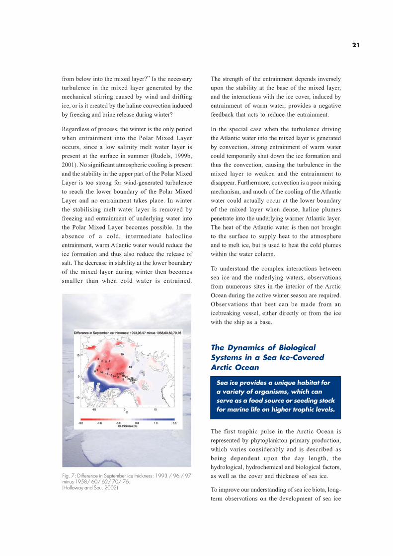
In winter, nutrients in the water column are
abundant as a consequence of vertical mixing, but
light is not sufficient for phytoplankton growth
(Fig.8). The spring increase of incident irradiance
and day length, trigger the start of the growing
season. At first the amount and quality of light
entering the water column below is strongly
reduced by the ice cover: for this reason
phytoplankton metabolism under the pack ice is
Fig. 8: Schematic illustration of the ice-edge effect. (from Sakshaug, 1990).
Part 1The Arctic Ocean and Global Climate Change – Atmosphere, Sea Ice & Ocean
23
very low and most of the algae are found in the ice,
clustered in long chains from the undersides of
ice, and the communities are mainly represented
by colonial chain-forming diatoms (for example
Melosira arctica). The major input of organic
carbon in these ice-covered regions is therefore
produced by under-ice flora and also most of
zooplankton grazing activity has been observed
here (Syvertsen, 1991). The ice melting gives rise
to the following changes in the water column: 1)
increased light penetration; 2) inoculation of algae
from ice; and 3) enhancement of vertical stability
that is due not only to freshwater inputs but also
to reduced wind stress. Phytoplankton bloom
phases, pulsed by diatoms and the
prymnesophicaean Phaeocystis pouchetii, start at
the ice edge but throughout the summer move
northwards (Rey and Loeng, 1985; Strass and
Nöthig, 1996). Primary production measurements
in the marginal ice show high values (up to >1 g C
m-2 day-1), during the growth season, for example in
the Barents Sea (Savinov, 1992), in the Fram Strait
(Codispoti et al., 1991) and in the Canadian Arctic
(Pesant et al., 1996).
Zooplankton (mainly copepods and protozoans)
appears to be able to respond immediately to any
increase in phytoplankton biomass and hence
grazing reduces the standing stock (Hansen et al.,
1995). In the same way the ice melting leaves
nutrient-impoverished water behind (Fig. 8). To the
south of the ice edge the nutrient depletion at the
surface of the open waters is often very
pronounced and phytoplankton biomass becomes
low, while a deep chlorophyll maximum occurs at
the nutricline depth (Sakshaug, 1990). Species
composition in open waters is typical of a post-
bloom state, mainly represented by auto- and
heterotrophic flagellates, large heterotrophic
dinoflagellates and several ciliates (Owrid et al.,
2000). In these waters the contribution of
regenerated production seems to support
consistently the net community production within
the euphotic layer (Luchetta et al., 2000).
Sedimentation rates of living cells from the euphotic
zone are low in the open waters and under the thick
pack ice and the sinking material consists mainly
of faecal pellets (Andreassen et al., 1996), further
illustrating the importance of zooplankton grazing
(Hulth et al., 1996). It is only at the ice edge that the
zooplankton community seems unable to control
the spring phytoplankton bloom and the
sedimentation of living phytoplankton is therefore
dominant and represents the main source of carbon
for the benthos.
There is little information for ice-covered regions
during the winter; for instance one of the most
studied areas in the Arctic (the western and
northern waters of Svalbard) lacks the ecological
information of the winter periods (Strömberg, 1989).
Biologically, sea ice provides a unique environment
that is exploited by wide variety of organisms, from
bacteria to mammals. The best known of the ice-
associated assemblages is that of the ice algae
although information on ice fauna and bacteria has
been gradually accumulating (Horner, 1990). For
this reason winter measurements in the regions
north of 80°latitude appear necessary in order to
know the ice algae distribution and metabolism and
the biology of the water column under the thick
pack ice.
Therefore the chance offered by a research vessel
working during wintertime can greatly enhance our
capabilities to understand the biological dynamics
in the Arctic system on a all year-round basis.
Satellite Remote Sensing
Sea ice properties on basin scale canbe obtained only by remote sensingtechniques which need permanentground-truthing to assure their quality.
A central task for detecting and understanding the
Arctic Ocean system is to determine the sea ice
budget. Remote sensing is of outstanding
importance in this respect. The following aspects
have to be considered:
. extent and area are well observed by satellite
microwave data (since 1978) (Gloersen et al.,
1992)
. thickness is poorly observed and the main
reason why the ice budget is not well known
24
. present data on thickness are scarce and
insufficient to understand the regional and
seasonal variability (Wadhams, 2000)
. fluxes through straits are being investigated
(Vinje et al., 1998), but are more accurate
estimates required?
. what is the contribution of sea ice to the
freshwater budget? This brings up the need
for more oceanographic data
. how well are coupled ice-ocean models driven
by atmospheric forcing able to reproduce
realistic sea ice extent and thickness? Validation
of such models is of high priority, but availability
of good validation data sets is again a key issue
. the relevance of MIZ processes for Arctic
ecosystems
. the contributions of sea ice growth, deformation
and drift to the redistribution of ice masses in
the Arctic Ocean.
Besides the well-established passive microwave
system SSM/I which provides data on sea ice
concentration and extent, three types of sea ice
remote sensing observations are used.
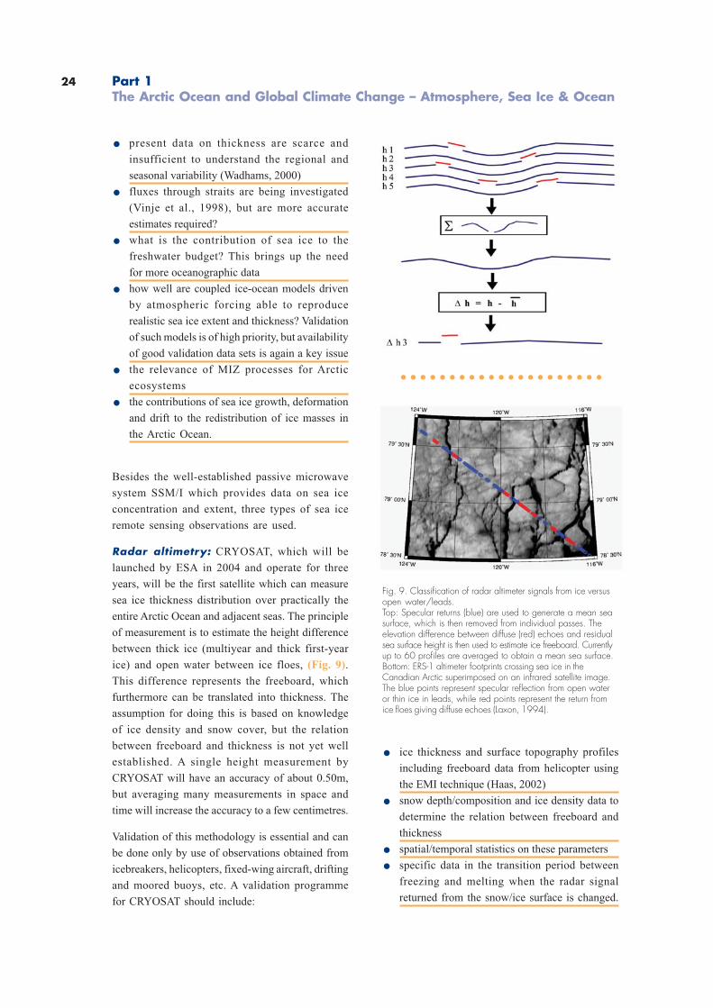
Radar altimetry: CRYOSAT, which will be
launched by ESA in 2004 and operate for three
years, will be the first satellite which can measure
sea ice thickness distribution over practically the
entire Arctic Ocean and adjacent seas. The principle
of measurement is to estimate the height difference
between thick ice (multiyear and thick first-year
ice) and open water between ice floes, (Fig. 9).
This difference represents the freeboard, which
furthermore can be translated into thickness. The
assumption for doing this is based on knowledge
of ice density and snow cover, but the relation
between freeboard and thickness is not yet well
established. A single height measurement by
CRYOSAT will have an accuracy of about 0.50m,
but averaging many measurements in space and
time will increase the accuracy to a few centimetres.
Validation of this methodology is essential and can
be done only by use of observations obtained from
icebreakers, helicopters, fixed-wing aircraft, drifting
and moored buoys, etc. A validation programme
for CRYOSAT should include:
Fig. 9. Classification of radar altimeter signals from ice versusopen water/leads.Top: Specular returns (blue) are used to generate a mean seasurface, which is then removed from individual passes. Theelevation difference between diffuse (red) echoes and residualsea surface height is then used to estimate ice freeboard. Currentlyup to 60 profiles are averaged to obtain a mean sea surface.Bottom: ERS-1 altimeter footprints crossing sea ice in theCanadian Arctic superimposed on an infrared satellite image.The blue points represent specular reflection from open wateror thin ice in leads, while red points represent the return fromice floes giving diffuse echoes (Laxon, 1994).
. ice thickness and surface topography profiles
including freeboard data from helicopter using
the EMI technique (Haas, 2002)
. snow depth/composition and ice density data to
determine the relation between freeboard and
thickness
. spatial/temporal statistics on these parameters
. specific data in the transition period between
freezing and melting when the radar signal
returned from the snow/ice surface is changed.
○ ○ ○ ○ ○ ○ ○ ○ ○ ○ ○ ○ ○ ○ ○ ○ ○ ○ ○ ○ ○
Part 1The Arctic Ocean and Global Climate Change – Atmosphere, Sea Ice & Ocean

25
Laser altimetry: ICESat, launched by NASA in
2002, provides laser measurements of the sea’s ice
surface. These data can provide information about
freeboard in a similar manner to radar altimeter
under cloud-free conditions and when there is
sufficient light. The laser altimeter will measure the
snow surface, whereas the radar altimeter will
measure the interface between ice and snow, at
least during dry conditions. Estimation of snow
depth can, in principle, be done by combining data
from ICESat and CRYOSAT. A validation programme
for ICESat will be similar to that for CRYOSAT.
SAR imagery: Large amounts of SAR imagery over
sea ice have been obtained since 1991 using ERS-
1/2 and RADARSAT. However, the validation of
SAR signatures of various ice processes (melting,
freezing, deformation, etc.) has been done only in
a few field experiments. With the launch of
ENVISAT and later RADARSAT 2 and 3, there will
be new capabilities from the SAR systems (that is,
dual polarisation, variable incidence angle, etc.)
which will improve the possibility of making a more
accurate ice classification and retrieving other ice
parameters (leads, ridges, etc.). Validation
experiments using icebreakers are needed to
establish relations between these ice parameters
and the new SAR data. SAR ice classification based
on ENVISAT data, for example, can be established
as a routine procedure in operational ice monitoring
in Europe, similar to that which the US and
Canadian Ice Centers are doing by using
RADARSAT data. One specific application of the
SAR data will be to identify and classify open
water/thin ice in leads along the lines of CRYOSAT/
ICESat and compare the altimeter signature with
the SAR signature. These data will be useful for
improvement of the ice thickness-retrieval algorithm
for CRYOSAT/ICESat. Another application of SAR
ice validation results is in the use of Scatterometer
data for operational ice monitoring in the context
of EUMETSAT.
Optical satellite data: The major use of optical
satellite data occurs through the AVHRR, MODIS
and MERIS systems. They provide high resolution
visible images of the sea ice which are used to
determine sea ice concentration, extent and small
scale processes. Use of ocean colour data from
satellites can be important for studies of chlorophyll
in the open water outside the MIZ, for sediment
transport from rivers and other processes in the
ice-free parts of the Arctic Ocean. Most of the
satellite-derived data will need ground-truthing
experiments during all seasons of the year, in the
marginal zone as well as in the central Arctic Ocean.
Remote Sensing Validation
Winter Ground-Truth and otherUses of Remote Sensing Data
AURORA BOREALIS will be used as a platform
for a variety of satellite remote sensing validation
measurements. These are mostly performed by
means of helicopter surveys, or in-situ ice core
drilling and analysis. Helicopter measurements are
most essential for the validation of CRYOSAT
thickness retrievals.
. Ice thickness will be surveyed by means of
helicopter EM sounding on length scales of >
100km. As the ship serves as a moving landing
platform, daily surveys from different take-off
locations can enable basin-scale surveys.
. Pressure ridge frequency and distributions and
other surface roughness information will be
obtained along these profiles as well by means
of laser altimetry.
. Nadir video and still photography will also be
performed on those flights, allowing for the
determination of ice concentration and ice type.
. Systems under development include snow
thickness radar and scatterometers, which
provide additional information important for the
validation and interpretation of CRYOSAT
thickness retrievals and SCAR ice signatures.
These can be obtained on >100km scales as
well.
. Since snow thickness is one of the most
important parameters for the accuracy of
CRYOSAT thickness retrievals, snow thickness
distributions will be measured on ice floes along
the ship’s track by means of ruler
measurements.
26
. Similarly, ice type, salinity, crystal and pore
texture, and density and their spatial variability
will be measured with ice cores obtained from
floes along the ship’s track.
. AURORA BOREALIS as a research platform
will permit repeated, systematic thickness
profiling across key regions (“hot spot
sampling”) such as in the Fram Strait or between
Greenland and the North Pole, to directly
observe the spatial and temporal variability of
the ice thickness distribution.
AURORA BOREALIS will contribute to the Global
Monitoring for Environment and Security (GMES)
ESA/EU programme to promote usage of Earth
Observation data for operational monitoring) by
obtaining in-situ ice data for monitoring and
validation purposes.
Ocean
Arctic Ocean Circulation
Ocean circulation transports heat,freshwater, nutrients, gases andpollutants within the Arctic Oceanand across its boundaries. Variationsof these transports affect all elementsof the Arctic Ocean system as well asthe adjacent ocean basins and have aparticularly strong impact on Europe.
The large-scale circulation in the Arctic Ocean
consists mainly of basin-scale gyres which are
interconnected (Fig. 3). The exchange between the
basins may occur either through gaps in the ridges
as lenses associated with eddies (Schauer et al.,
2002b) or by the boundary current which leads
relatively warm and saline water of Atlantic origin
from the Nordic Seas through the Fram Strait and
the Barents Sea into and around the Arctic Ocean.
The Atlantic water recirculates along different paths
(Rudels and Friedrich, 2000; Rudels, 2001),
undergoing extensive modification. River runoff
from the continents adds a significant volume of
freshwater, and water of lower salinity is supplied
by the Pacific through the Bering Strait (Roach et
al., 1995). Deep water from the Eurasian and
Canadian basins leaves the Arctic Ocean through
the Fram Strait. Upper, less saline, water masses
also exit through the Fram Strait and the Canadian
Arctic Archipelago into the Labrador Sea.
During recent years significant changes have been
observed in the Arctic. They include decadal
variations in the atmospheric conditions which
affect the Arctic Ocean circulation. A decrease and
eastward shift of the Beaufort high in the 1990s is
described as part of the Arctic Oscillation, which is
related to the North Atlantic Oscillation. Shifts in
hydrographic fronts (Carmack et al., 1995;
McLaughlin et al., 1996; Morison et al., 1998;
McLaughlin et al., 2002) illustrate the effect of
variations in the circulation, which can be
evidenced in particular for the Beaufort gyre in
models (Proshutinsky and Johnson, 1997;
Maslowski et al., 2000).
Part 1The Arctic Ocean and Global Climate Change – Atmosphere, Sea Ice & Ocean
27
Our present knowledge of the circulation is mostly
based on the interpretation of the distributions of
water mass properties and on models. Only a few
direct measurements exist from moored instruments,
which are able to resolve the spectrum of relevant
time scales (Aagaard and Carmack, 1994; Woodgate
et al., 2001). Those measurements are local and of
too short a duration to address climate time scales.
Variations on interannual to decadal time scales
are evidenced by the variations in the water mass
properties. However, due to the observational gaps
of up to several years, a serious aliasing problem
exists (Karcher et al., 2003). A better coverage exists
at the boundaries where current meter
measurements are carried out in the Fram Strait
(Fahrbach et al., 2001), the Barents Sea opening
(Ingvaldsen et al., 2002), the Bering Strait (Roach
et al., 1995) and part of the Canadian Archipelago.
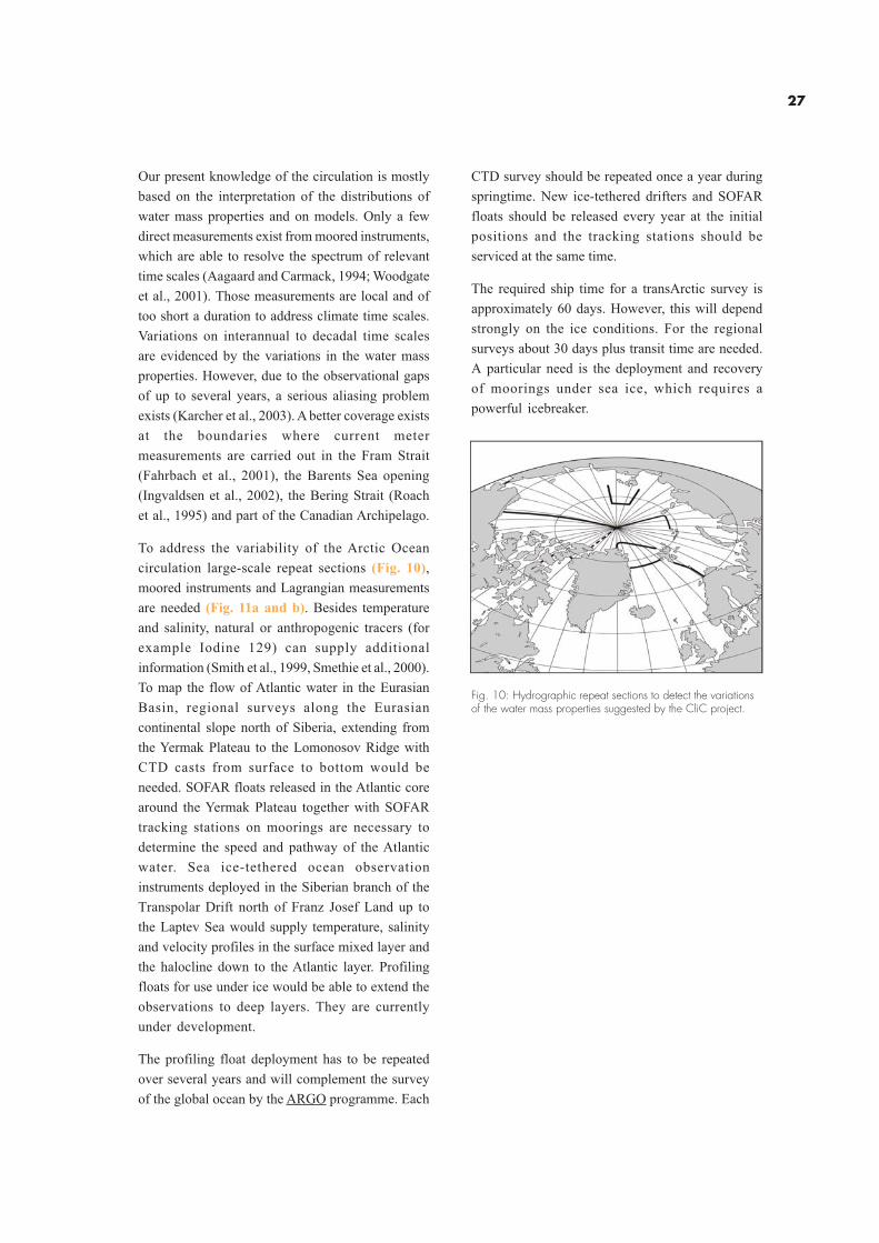
To address the variability of the Arctic Ocean
circulation large-scale repeat sections (Fig. 10),
moored instruments and Lagrangian measurements
are needed (Fig. 11a and b). Besides temperature
and salinity, natural or anthropogenic tracers (for
example Iodine 129) can supply additional
information (Smith et al., 1999, Smethie et al., 2000).
To map the flow of Atlantic water in the Eurasian
Basin, regional surveys along the Eurasian
continental slope north of Siberia, extending from
the Yermak Plateau to the Lomonosov Ridge with
CTD casts from surface to bottom would be
needed. SOFAR floats released in the Atlantic core
around the Yermak Plateau together with SOFAR
tracking stations on moorings are necessary to
determine the speed and pathway of the Atlantic
water. Sea ice-tethered ocean observation
instruments deployed in the Siberian branch of the
Transpolar Drift north of Franz Josef Land up to
the Laptev Sea would supply temperature, salinity
and velocity profiles in the surface mixed layer and
the halocline down to the Atlantic layer. Profiling
floats for use under ice would be able to extend the
observations to deep layers. They are currently
under development.
The profiling float deployment has to be repeated
over several years and will complement the survey
of the global ocean by the ARGO programme. Each
Fig. 10: Hydrographic repeat sections to detect the variationsof the water mass properties suggested by the CliC project.
CTD survey should be repeated once a year during
springtime. New ice-tethered drifters and SOFAR
floats should be released every year at the initial
positions and the tracking stations should be
serviced at the same time.
The required ship time for a transArctic survey is
approximately 60 days. However, this will depend
strongly on the ice conditions. For the regional
surveys about 30 days plus transit time are needed.
A particular need is the deployment and recovery
of moorings under sea ice, which requires a
powerful icebreaker.
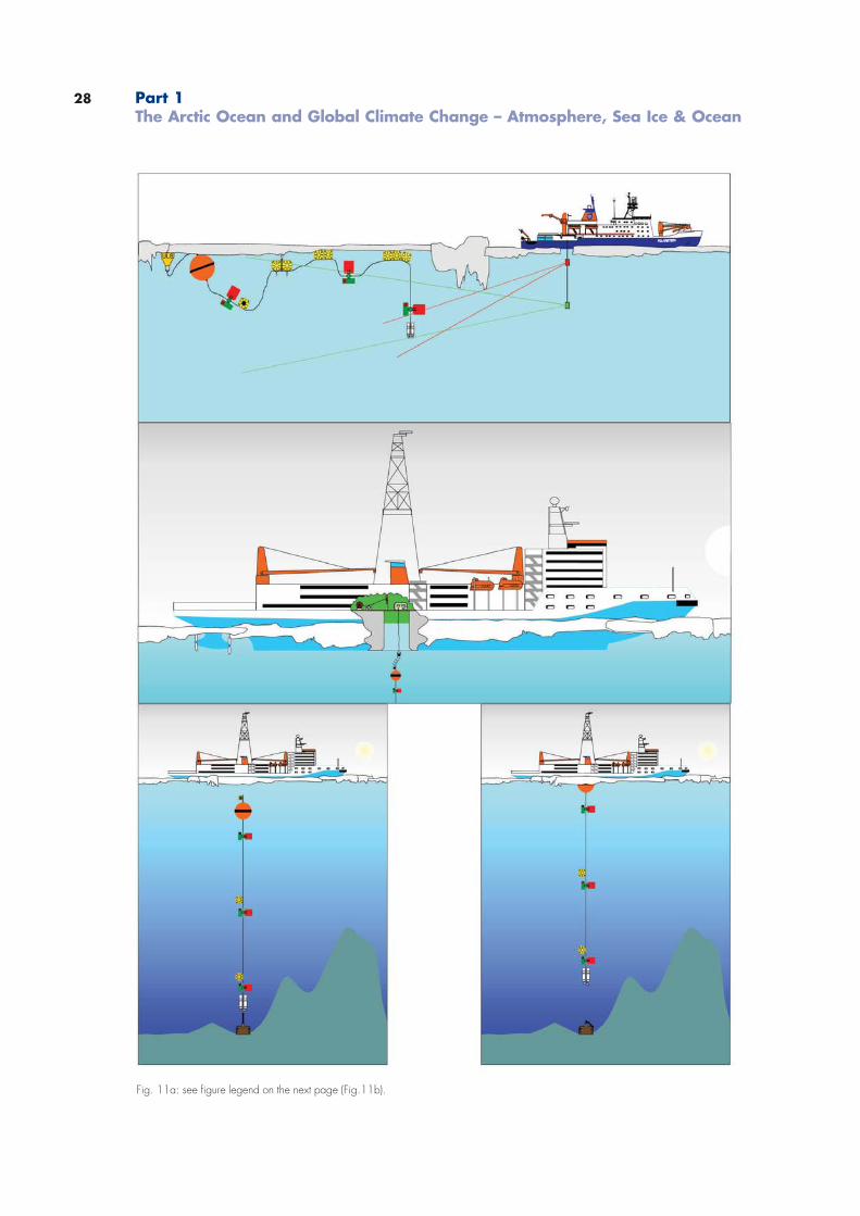
28
Fig. 11a: see figure legend on the next page (Fig.11b).
Part 1The Arctic Ocean and Global Climate Change – Atmosphere, Sea Ice & Ocean
29
Hybrid Arctic Float Observation System – “HAFOS”
Fig.11 b: Combined observation system with moored instruments, sea ice-tethered ocean instruments and profiling floats in theArctic Ocean.
Water Mass Conversions on ArcticOcean Shelves
Water mass conversions on the Arcticshelves control the water properties ofthe interior Arctic Ocean.
Ten percent of the global river runoff discharges
into the Arctic shelf seas. The distribution and
modification of this huge freshwater supply are
expected to strongly affect the global thermohaline
circulation. With the exception of the deep Fram
Strait, exchange between the Arctic and the Atlantic
and Pacific oceans also takes place across shelf
seas (Schauer et al., 2002a; Roach et al., 1995;
Gerdes et al., 2003). Before the freshwater input
from rivers and the Atlantic and Pacific inflows enter
the central Arctic and eventually leave it, they are
strongly modified through various processes
taking place on the shelves (Bauch et al., 2003;
Harms et al., 2003). Depending on the atmospheric
wind regime (Atlantic Oscillation), the river water is
retained and circulating on the shelves for several
years or it enters the central Arctic Ocean more
directly (Maslowski et al., 2000).
Shelves are shallow so that tide- and wind-induced
mixing may affect the whole water column and
convective mixing easily extends to the bottom.
Furthermore, latent heat polynias, generated by
wind-driven ice divergence, are localised by islands,
coasts and landfast ice, which are features of the
shelves (Midttun, 1985). Admixture of freshwater
and salt release during ice formation are
counteracting processes which determine the
density of shelf water and thus their ability to
ventilate the upper, intermediate and deep layers
of the ocean and thereby contribute to the
thermohaline circulation.
30
In contrast to the deep basins, the shelves of the
Arctic Ocean are almost ice free in summer
(Gloersen et al., 1992). In autumn the water cools
rapidly to freezing temperatures and ice is formed.
The open water allows larger ice formation per unit
area than the ice cover in the interior Arctic Ocean.
However, ice is also imported from the deep basins
and melts on the shelves. The net annual mean ice
production in the deep basins and on the individual
shelves and the corresponding freshwater/salt
balance is not known.
Many of these processes have been inferred
theoretically but detailed observations of the
different steps are still lacking. This concerns
freezing and brine rejection, convection and dense
water accumulation, as well as the mixing and
dilution of the dense bottom water with ambient
water masses and its advection towards the shelf
break. To study these processes, field work during
the active winter season is necessary. Ice camps
cannot be used without excessive hazard in the
marginal ice zones connected with polynias and
leads. To reach and operate in these areas in winter
requires an icebreaker.
The Role of Polynias for theWater Mass Conversions of theArctic Ocean
Polynias are areas of extremeatmosphere-ocean interaction, whichresults in water mass conversions andaffects on marine biota.
The sea ice cover of the Arctic Ocean forms an
isolating sheet, which effectively inhibits the
temperature and gas exchange between the ocean
and the atmosphere. In some areas and during
certain events, however, the closed ice cover opens
and the surface water is exposed to the atmosphere
(Lemke, 2001). These open water areas are called
polynias when they occur repeatedly at the same
location. They form a “window” to the atmosphere
where intense thermodynamic exchange can take
place (Pease, 1987; Winsor and Björk, 2000).
Polynias are maintained free of ice by two different
physical processes (Smith et al., 1990). Heat-
sensitive polynias form when relatively warm water
upwells towards the surface where it melts the ice
cover or prevents ice from forming. Latent heat
polynias form in areas where ice diverges as soon
as it is formed due to the wind or current field. This
process often happens in the lee of islands or along
shorelines in the presence of offshore winds
(Drucker and Martin, 2003).
During winter, wind-induced latent heat polynias
experience strong heat loss to the atmosphere and
intense thermodynamic ice production. Brine
release and subsequent convection lead to strong
vertical mixing which affects the hydrographic
structure of the stratified ambient waters below the
ice. Latent heat polynias play an important role in
water mass transformation and the formation of
dense bottom water in the Arctic Ocean and its
marginal shelf seas (Cavalieri and Martin, 1994).
Because of severe weather conditions or
inaccessibility of appropriate areas, the
hydrographic structures in and near latent heat
polynias during winter are hardly known. One
recurrent latent heat polynia exists in Storfjorden
in southern Svalbard where the outflow of dense
water was intensively studied (Haarpainter et al.
2001; Schauer and Fahrbach, 1999; Fer et al., 2003).
Furthermore, in Whalers’ Bay north of Svalbard
the other type of polynia is present. Here the warm
Atlantic water of the West Spitsbergen Current
encounters and melts sea ice formed in the Arctic
Ocean and transported towards the Fram Strait.
The melt water is stirred into the Atlantic water
transforming its upper part into a cold, less saline
layer above the warm, saline core of the Fram Strait
inflow branch. This upper layer is believed to be
the embryo of the halocline located above the
Atlantic layer in the interior of the Arctic Ocean
(Rudels et al., 1996), which inhibits the vertical
transport of heat from the Atlantic layer to the ice
cover and the atmosphere. The primary aim of
studying polynias is to especially investigate latent
heat polynias and to evaluate their relevance for
the climate of the Arctic Ocean. Such studies
involve several disciplines. The purpose of the
oceanographic work is to:
Part 1The Arctic Ocean and Global Climate Change – Atmosphere, Sea Ice & Ocean
31
. capture the mesoscale hydrographic structure in
a latent and a sensible heat polynia
. investigate turbulent salt, momentum and heat
fluxes during ice formation
. determine temporal and spatial scales of
convection and dense plume formation
. observe the temporal and spatial scales of
outflow of dense bottom water
. determine the dynamics which control bottom
plume propagation and mixing.
Measurements have been possible only since the
advent of new ship- and airborne electromagnetic
(EM) sensors for accurate ice thickness sounding.
The measurements should be performed along
extended transects parallel to the main ice drift
direction to observe thickness gradients. The
thickness measurements should be complemented
by measurements of vertical profiles of ice salinity
and temperature. Another aim of the measurements
is to gather ground-truth data for the development
of algorithms to retrieve the relevant sea ice
parameters (surface temperature and roughness,
thickness) from satellite data (NOAA AVHRR,
ENVISAT AATSR and ASAR).
During 2001 the news media reported the
disappearance of the ice over the North Pole and
the generation of huge open channels. These news
reports generated much excitement all over the
world although it was due to a natural process.
This news event clearly illustrates the ignorance
about processes of the formation and maintenance
of polynias in the Arctic sea ice cover, in particular
during the unfavourable seasons of the year.
Multidisciplinary field studies resolving the annual
cycle will be needed to study their dynamics.
Ventilation of Arctic Ocean Watersby Shelf-Basin Exchange
Water masses formed on the shelvesdescend the continental slope inshort-lived and small-scale plumes tointermediate and deep layers.
The shelf edge forms a boundary for shelf-typical
processes and determines the mechanisms by
which central basin and shelf water masses are
exchanged. Instabilities of fronts allow upper layer
waters to cross the shelf-break and transfer shelf
water into the interior Arctic Ocean gyres (Swift et
al., 1997). Submarine canyons, such as the St Anna
Trough, channel the drainage of dense shelf water
and also allow water from central basins to enter
the shelf.
The strong stability of the water column in the
interior Arctic Ocean limits the local convection to
the upper 100m, and the deeper layers are ventilated
by advection of dense waters from the Nordic Seas
or by dense shelf water convecting down the
continental slope. The shelf-basin interactions
occur as two types: 1) as injection of water advected
from outside the Arctic Ocean; and 2) by the input
of dense water, created on the shelves by brine
rejection and haline convection in winter.
The strong flow down the St Anna Trough is
essentially an inflow from the Nordic Seas, cooled
and transformed in the Barents Sea, which merges
isopycnally with the Fram Strait inflow branch in
the boundary current north of the Kara Sea
(Schauer et al., 2002b). The inflow through the
Bering Strait is similar to the inflow of the Barents
Sea branch, but because of its lower salinity the
Pacific water cannot ventilate the deep Arctic
Ocean, unless it experiences a salinity and density
increase on the Chukchi Shelf caused by ice
formation and brine rejection. A density increase
partly takes place also in the Barents Sea but ice
formation is not necessary for the Barents Sea
branch to ventilate the intermediate layers.
32
Slope convection proper occurs as thin intermittent
boundary plumes of highly saline and dense shelf
water sink into the deep (Rudels and Friedrich, 2000).
Few deep plumes have been observed in the Arctic
Ocean and most of what is assumed about their
physics and dynamics has been inferred from
differences in temperature/salinity characteristics
between the deep and intermediate waters in the
Arctic Ocean and in the Nordic Seas (Anderson et
al., 1999). The slope plumes must, in contrast to
the St Anna Trough inflow, be strongly entraining.
This implies a substantial one-way exchange
between the upper layers and the deep ocean, even
if the amount of water that leaves the shelves is
small. Slope convection is the main cooling
mechanism for the Atlantic layer, either by plumes
reaching their terminal depth at the Atlantic layer
and merging with the Atlantic water or by denser
plumes sinking through the Atlantic layer,
entraining and transferring warm water downwards.
The high initial salinity of the shelf bottom waters
and the entrainment of warm Atlantic water
determine the characteristic temperature/salinity
properties of the Arctic Ocean deep waters.
To test if the plume hypothesis is tenable, winter
and early spring observations at the continental
slope are needed, especially close to areas of
persistent polynias, where dense water formation
is expected to take place.
Determining details of the inflow of the Barents
Sea branch in the St Anna Trough (Schauer et al.,
2002a) is of equal importance. The Barents Sea
branch mainly supplies water to the 200-1 200m
layer, but it could occasionally have a denser bottom
layer which separates from the main inflow and
sinks down the slope into the deep Nansen Basin.
Since it enters at a much greater depth (1 000m)
than the shelf water it would not entrain the less
saline upper water or the warm Atlantic water. It
could therefore reach great depths without a strong
temperature increase and without having the
excessive initial salinities required on the shallow
shelves.
The study of slope convection requires the
capability to reach the shelf break and the slope in
specific regions during winter and also to be able
to follow plumes should these be encountered.
The ice conditions are expected to be severe.
This task cannot be completed from a drifting ice
station but only with a manoeuvrable strong
icebreaker.
Biodiversity in the CentralArctic Ocean
Since biodiversity cannot bequantified in the central ArcticOcean the effect of global changeon marine life cannot be estimated.
The majority of past expeditions to the Arctic
were carried out during the summer season.
Therefore, a sound database on the biology of
organisms inhabiting the sea ice, the water
column or the seafloor is available for many
regions of the marginal Arctic Ocean and its
surrounding shelf seas during this period of the
year. In contrast there are only few and randomly
scattered samples taken in the central Arctic
Ocean and very little information on seasonal
aspects such as reproductive cycles,
overwintering strategies and metabolic
adaptations during winter is available.
Additionally, there is only limited information
about species composition and distribution in
the three marine sub-systems (cryosphere,
pelagic and benthic realm) for the central Arctic.
There is scientific evidence from terrestrial
ecosytems that higher diversity may keep a
system more resilient to disturbances than less
diverse systems. Whether or not this holds true
for marine systems is uncertain. The few
quantitative zoobenthos samples taken in some
of the permanent ice-covered regions of the
Arctic gave moderately high diversity indices
for the macrozoobenthos. Because large motile
epifauna organisms modify and structure the
sediment surface “benthic engineering”, thus
creating microhabitats for smaller species, any
loss of large species should consequently also
lead to a loss of such habitats and their inhabiting
species. Among this systematic sampling of the
Arctic marine biosphere one of the main
Part 1The Arctic Ocean and Global Climate Change – Atmosphere, Sea Ice & Ocean
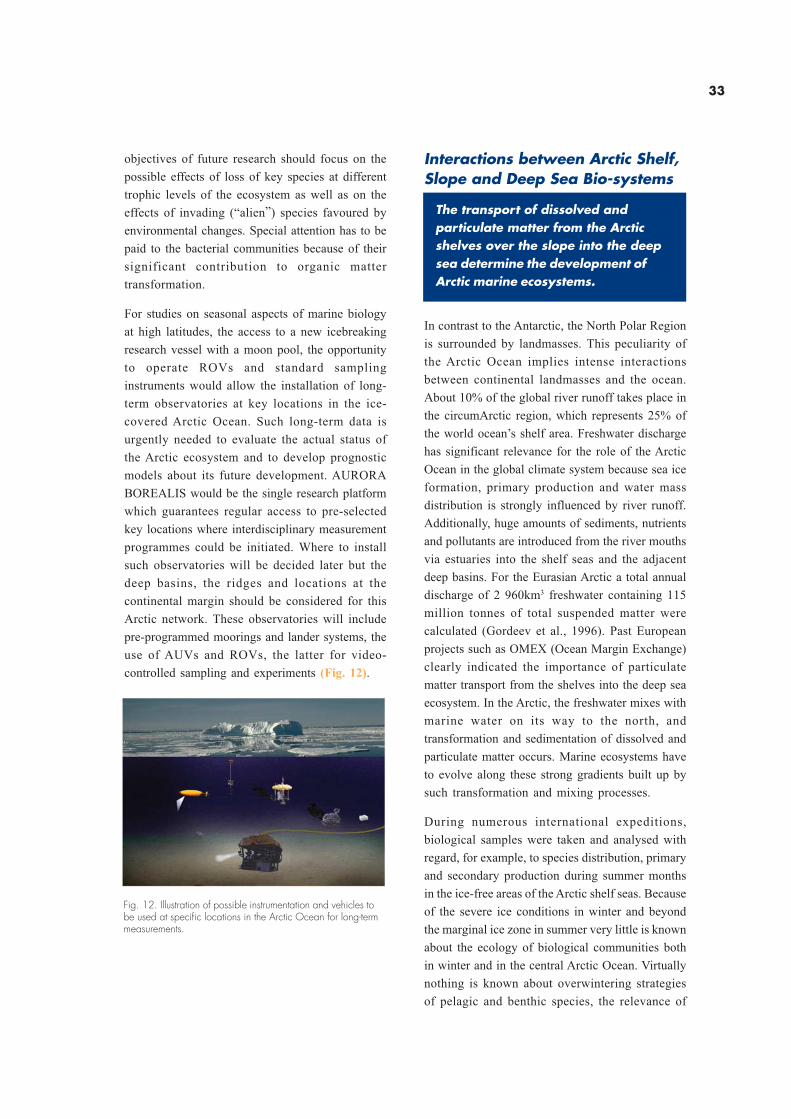
33
objectives of future research should focus on the
possible effects of loss of key species at different
trophic levels of the ecosystem as well as on the
effects of invading (“alien”) species favoured by
environmental changes. Special attention has to be
paid to the bacterial communities because of their
significant contribution to organic matter
transformation.
For studies on seasonal aspects of marine biology
at high latitudes, the access to a new icebreaking
research vessel with a moon pool, the opportunity
to operate ROVs and standard sampling
instruments would allow the installation of long-
term observatories at key locations in the ice-
covered Arctic Ocean. Such long-term data is
urgently needed to evaluate the actual status of
the Arctic ecosystem and to develop prognostic
models about its future development. AURORA
BOREALIS would be the single research platform
which guarantees regular access to pre-selected
key locations where interdisciplinary measurement
programmes could be initiated. Where to install
such observatories will be decided later but the
deep basins, the ridges and locations at the
continental margin should be considered for this
Arctic network. These observatories will include
pre-programmed moorings and lander systems, the
use of AUVs and ROVs, the latter for video-
controlled sampling and experiments (Fig. 12).
Fig. 12. Illustration of possible instrumentation and vehicles tobe used at specific locations in the Arctic Ocean for long-termmeasurements.
Interactions between Arctic Shelf,Slope and Deep Sea Bio-systems
The transport of dissolved andparticulate matter from the Arcticshelves over the slope into the deepsea determine the development ofArctic marine ecosystems.
In contrast to the Antarctic, the North Polar Region
is surrounded by landmasses. This peculiarity of
the Arctic Ocean implies intense interactions
between continental landmasses and the ocean.
About 10% of the global river runoff takes place in
the circumArctic region, which represents 25% of
the world ocean’s shelf area. Freshwater discharge
has significant relevance for the role of the Arctic
Ocean in the global climate system because sea ice
formation, primary production and water mass
distribution is strongly influenced by river runoff.
Additionally, huge amounts of sediments, nutrients
and pollutants are introduced from the river mouths
via estuaries into the shelf seas and the adjacent
deep basins. For the Eurasian Arctic a total annual
discharge of 2 960km3 freshwater containing 115
million tonnes of total suspended matter were
calculated (Gordeev et al., 1996). Past European
projects such as OMEX (Ocean Margin Exchange)
clearly indicated the importance of particulate
matter transport from the shelves into the deep sea
ecosystem. In the Arctic, the freshwater mixes with
marine water on its way to the north, and
transformation and sedimentation of dissolved and
particulate matter occurs. Marine ecosystems have
to evolve along these strong gradients built up by
such transformation and mixing processes.
During numerous international expeditions,
biological samples were taken and analysed with
regard, for example, to species distribution, primary
and secondary production during summer months
in the ice-free areas of the Arctic shelf seas. Because
of the severe ice conditions in winter and beyond
the marginal ice zone in summer very little is known
about the ecology of biological communities both
in winter and in the central Arctic Ocean. Virtually
nothing is known about overwintering strategies
of pelagic and benthic species, the relevance of
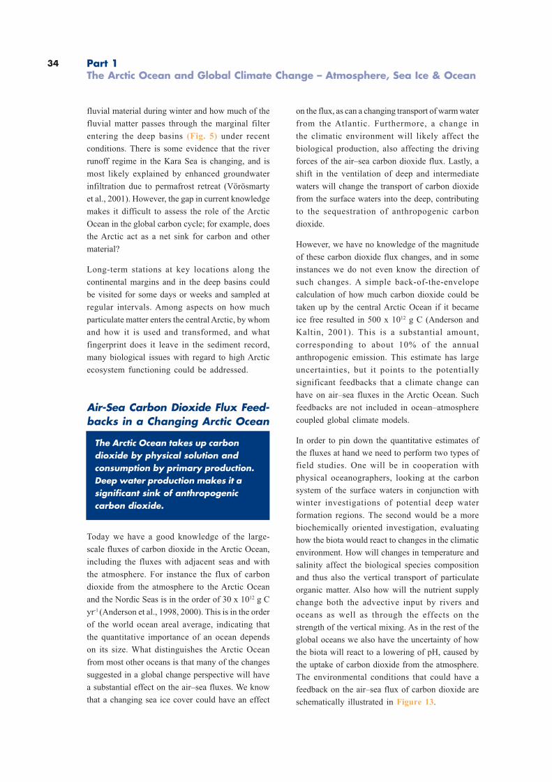
34
fluvial material during winter and how much of the
fluvial matter passes through the marginal filter
entering the deep basins (Fig. 5) under recent
conditions. There is some evidence that the river
runoff regime in the Kara Sea is changing, and is
most likely explained by enhanced groundwater
infiltration due to permafrost retreat (Vörösmarty
et al., 2001). However, the gap in current knowledge
makes it difficult to assess the role of the Arctic
Ocean in the global carbon cycle; for example, does
the Arctic act as a net sink for carbon and other
material?
Long-term stations at key locations along the
continental margins and in the deep basins could
be visited for some days or weeks and sampled at
regular intervals. Among aspects on how much
particulate matter enters the central Arctic, by whom
and how it is used and transformed, and what
fingerprint does it leave in the sediment record,
many biological issues with regard to high Arctic
ecosystem functioning could be addressed.
Air-Sea Carbon Dioxide Flux Feed-backs in a Changing Arctic Ocean
The Arctic Ocean takes up carbondioxide by physical solution andconsumption by primary production.Deep water production makes it asignificant sink of anthropogeniccarbon dioxide.
Today we have a good knowledge of the large-
scale fluxes of carbon dioxide in the Arctic Ocean,
including the fluxes with adjacent seas and with
the atmosphere. For instance the flux of carbon
dioxide from the atmosphere to the Arctic Ocean
and the Nordic Seas is in the order of 30 x 1012 g C
yr-1 (Anderson et al., 1998, 2000). This is in the order
of the world ocean areal average, indicating that
the quantitative importance of an ocean depends
on its size. What distinguishes the Arctic Ocean
from most other oceans is that many of the changes
suggested in a global change perspective will have
a substantial effect on the air–sea fluxes. We know
that a changing sea ice cover could have an effect
on the flux, as can a changing transport of warm water
from the Atlantic. Furthermore, a change in
the climatic environment will likely affect the
biological production, also affecting the driving
forces of the air–sea carbon dioxide flux. Lastly, a
shift in the ventilation of deep and intermediate
waters will change the transport of carbon dioxide
from the surface waters into the deep, contributing
to the sequestration of anthropogenic carbon
dioxide.
However, we have no knowledge of the magnitude
of these carbon dioxide flux changes, and in some
instances we do not even know the direction of
such changes. A simple back-of-the-envelope
calculation of how much carbon dioxide could be
taken up by the central Arctic Ocean if it became
ice free resulted in 500 x 1012 g C (Anderson and
Kaltin, 2001). This is a substantial amount,
corresponding to about 10% of the annual
anthropogenic emission. This estimate has large
uncertainties, but it points to the potentially
significant feedbacks that a climate change can
have on air–sea fluxes in the Arctic Ocean. Such
feedbacks are not included in ocean–atmosphere
coupled global climate models.
In order to pin down the quantitative estimates of
the fluxes at hand we need to perform two types of
field studies. One will be in cooperation with
physical oceanographers, looking at the carbon
system of the surface waters in conjunction with
winter investigations of potential deep water
formation regions. The second would be a more
biochemically oriented investigation, evaluating
how the biota would react to changes in the climatic
environment. How will changes in temperature and
salinity affect the biological species composition
and thus also the vertical transport of particulate
organic matter. Also how will the nutrient supply
change both the advective input by rivers and
oceans as well as through the effects on the
strength of the vertical mixing. As in the rest of the
global oceans we also have the uncertainty of how
the biota will react to a lowering of pH, caused by
the uptake of carbon dioxide from the atmosphere.
The environmental conditions that could have a
feedback on the air–sea flux of carbon dioxide are
schematically illustrated in Figure 13.
Part 1The Arctic Ocean and Global Climate Change – Atmosphere, Sea Ice & Ocean
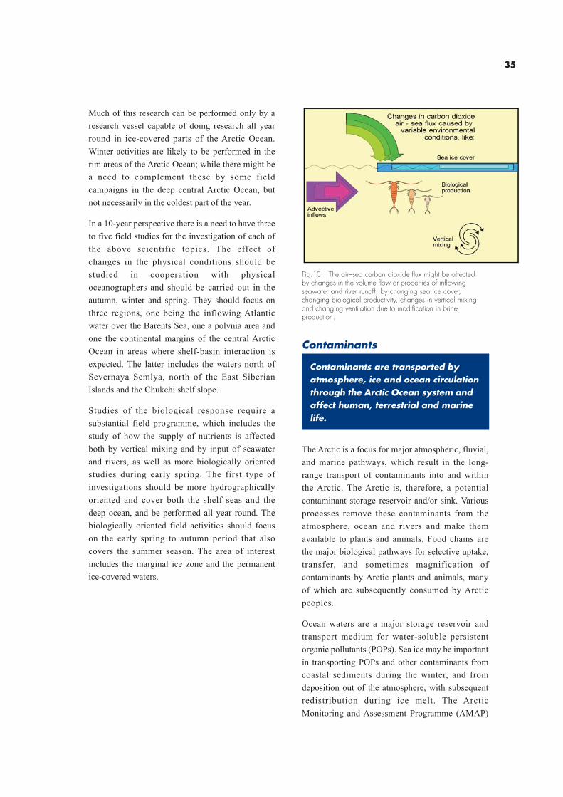
35
Much of this research can be performed only by a
research vessel capable of doing research all year
round in ice-covered parts of the Arctic Ocean.
Winter activities are likely to be performed in the
rim areas of the Arctic Ocean; while there might be
a need to complement these by some field
campaigns in the deep central Arctic Ocean, but
not necessarily in the coldest part of the year.
In a 10-year perspective there is a need to have three
to five field studies for the investigation of each of
the above scientific topics. The effect of
changes in the physical conditions should be
studied in cooperation with physical
oceanographers and should be carried out in the
autumn, winter and spring. They should focus on
three regions, one being the inflowing Atlantic
water over the Barents Sea, one a polynia area and
one the continental margins of the central Arctic
Ocean in areas where shelf-basin interaction is
expected. The latter includes the waters north of
Severnaya Semlya, north of the East Siberian
Islands and the Chukchi shelf slope.
Studies of the biological response require a
substantial field programme, which includes the
study of how the supply of nutrients is affected
both by vertical mixing and by input of seawater
and rivers, as well as more biologically oriented
studies during early spring. The first type of
investigations should be more hydrographically
oriented and cover both the shelf seas and the
deep ocean, and be performed all year round. The
biologically oriented field activities should focus
on the early spring to autumn period that also
covers the summer season. The area of interest
includes the marginal ice zone and the permanent
ice-covered waters.
Fig.13. The air–sea carbon dioxide flux might be affectedby changes in the volume flow or properties of inflowingseawater and river runoff, by changing sea ice cover,changing biological productivity, changes in vertical mixingand changing ventilation due to modification in brineproduction.
Contaminants
Contaminants are transported byatmosphere, ice and ocean circulationthrough the Arctic Ocean system andaffect human, terrestrial and marinelife.
The Arctic is a focus for major atmospheric, fluvial,
and marine pathways, which result in the long-
range transport of contaminants into and within
the Arctic. The Arctic is, therefore, a potential
contaminant storage reservoir and/or sink. Various
processes remove these contaminants from the
atmosphere, ocean and rivers and make them
available to plants and animals. Food chains are
the major biological pathways for selective uptake,
transfer, and sometimes magnification of
contaminants by Arctic plants and animals, many
of which are subsequently consumed by Arctic
peoples.
Ocean waters are a major storage reservoir and
transport medium for water-soluble persistent
organic pollutants (POPs). Sea ice may be important
in transporting POPs and other contaminants from
coastal sediments during the winter, and from
deposition out of the atmosphere, with subsequent
redistribution during ice melt. The Arctic
Monitoring and Assessment Programme (AMAP)
36 Part 1The Arctic Ocean and Global Climate Change – Atmosphere, Sea Ice & Ocean
has identified a need for knowledge of ocean
transport processes for different contaminants,
including ice transport and subsequent
contaminant release in melting (focusing) zones.
Information on contaminant levels and trends is
lacking for certain contaminants and media in the
Arctic Ocean. Furthermore, regarding seawater,
little is known about concentrations of most
organic contaminants in offshore areas within the
Arctic Ocean and adjacent seas, especially for
PCBs and toxaphene. Profiles of these
contaminants, with depth, which would allow
estimation of the total mass of these chemicals in
the ocean, are lacking. The general lack of
information on organochlorines (OCs) in the
Norwegian Coastal Current and East Greenland
Current is especially critical because of the
importance of these currents for inputs to and
outputs from the Arctic Ocean. There is no
information on fluxes of OCs to marine sediment
for any area of the Arctic Ocean. Knowledge of
losses via sedimentation and burial are critical to
make accurate budgets of PCBs and may also be
important for some toxaphene components. It is
recommended that sediment cores should be
collected at key locations in the Arctic Ocean.
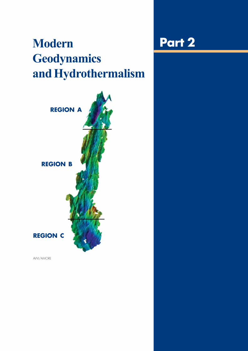
37
Modern
Geodynamics
and Hydrothermalism
Part 2
REGION A
REGION B
REGION C
AWI/AMORE
38
Modern Geodynamics
and Hydrothermalism –
Introduction
In 1999 and 2001 active volcanoeswere discovered at Gakkel Ridge deepbeneath the Arctic ice cover, withsubstantial hydrothermal activityinfluencing bottom waters.
As an important end member of the global ridge
system, as the last geologically and biologically
unsampled ridges, as a unique combination of
tectonic forcing functions, the Arctic Mid-ocean
Ridges are extremely interesting for research. Arctic
hydrothermal systems in general have a high
probability of supporting novel fauna based on
both the relative youth of the basin and ridge
system, and their isolation from deep waters of
Atlantic and Pacific Basins. The success of future
programmes in the ice-covered Arctic depends on
new technologies such as the use of remotely
operated vehicles (ROVs) and autonomous
underwater vehicles (AUVs) through a moon pool
of a research vessel.
The slowest opening rate of the active global
submarine ridge systems is found at the Gakkel
Ridge in the Eurasia Basin of the Arctic Ocean with
the assumed lowest melt production of the world’s
mid-ocean ridge systems. The Gakkel Ridge is a
continuation of the North Atlantic Mid-ocean Ridge
and has been active for the last 56 million years. Its
slow opening rate implies extremely low melt
production. Geophysical surveys of the oceanic
crust generated at the spreading centre suggest
thin crust, but a major rock-dredging effort by two
icebreakers during the Arctic Mid-Ocean Ridge
Expedition 2001 indicated a far more complex
situation (Michael et al. 2003; Jokat et al., 2003;
Thiede et al., 2002).
Sampling at special sites of scientific interest such
as hydrothermal vents (Edmonds et al., 2003) or
cold seeps need appropriate techniques. ROVs are
proven systems for this kind of video-controlled
work even at high latitudes and AUVs are currently
underway to become reliable new platforms for a
huge variety of sensors. At proposed long-term
stations in the Arctic Ocean the installation of
autonomous instruments, the deployment of
experimental devices, the recovery of data and
targeted sampling also needs ROVs. To elucidate
the interactions between the broad shelf areas and
the deep basins with regard, for example, to the
fate of fluvial matter originating from the large
Siberian rivers, such observatories are necessary
because the transport of freshwater, nutrients,
dissolved and particulate organic matter underlies
strong seasonal fluctuations. Moreover, according
to long-term measurements it seems that the river
runoff regime changed over the past decades in a
way that more freshwater enters the estuaries
because of increased groundwater infiltration due
to the retreat of the permafrost.
However, ice cover hampers the use of remotely
operated and autonomous vehicles because either
the ROV cable is most vulnerable to the ice or the
AUV cannot surface after its pre-programmed
mission. These problems can be overcome by using
a research vessel with a moon pool large enough
to launch and recover vehicles up to about 6m in
length. Underwater docking stations for AUVs were
recently developed and successfully tested in
North America and in Europe, hence recovery even
under ice cover is possible.
Part 2Modern Geodynamics and Hydrothermalism
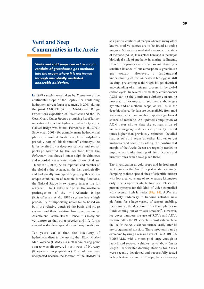
39
Vent and Seep
Communities in the Arctic
Vents and cold seeps can act as majorconduits of greenhouse gas methaneinto the ocean where it is destroyedthrough microbially mediatedanaerobic oxidation.
In 1998 samples were taken by Polarstern at the
continental slope of the Laptev Sea containing
hydrothermal vent fauna specimens. In 2001, during
the joint AMORE (Arctic Mid-Ocean Ridge
Expedition) expedition of Polarstern and the US
Coast Guard Cutter Healy, a promising list of further
indications for active hydrothermal activity at the
Gakkel Ridge was found (Edmonds et al., 2003;
Snow et al., 2001); for example, many hydrothermal
plumes, abundant fresh lava, fresh sulphides
probably part of “black smoker” chimneys, the
latter verified by a deep sea camera and sensor
package lowered to the seafloor from the
Polarstern that showed intact sulphide chimneys
and recorded warm water vents (Snow et al. in:
Thiede et al., 2002). As an important end member of
the global ridge system, as the last geologically
and biologically unsampled ridges, together with a
unique combination of tectonic forcing functions,
the Gakkel Ridge is extremely interesting for
research. The Gakkel Ridge as the northern
prolongation of the mid-Atlantic Ridge
(Kristoffersen et al., 1982) system has a high
probability of supporting novel fauna based on
both the relative youth of the basin and ridge
system, and their isolation from deep waters of
Atlantic and Pacific Basins. Hence, it is likely but
yet unproven that other species and life forms
evolved under these special evolutionary conditions.
Ten years earlier than the discovery of
hydrothermalism in the Arctic, the Håkon Mosby
Mud Volcano (HMMV), a methane-releasing point
source was discovered northwest of Norway
(Klages et al. in preparation.). This cold seep was
unexpected because the location of the HMMV is
at a passive continental margin whereas many other
known mud volcanoes are to be found at active
margins. Microbially mediated anaerobic oxidation
of methane (AOM) takes place here and is the major
biological sink of methane in marine sediments.
Hence this process is crucial in maintaining a
sensitive balance of our atmosphere’s greenhouse
gas content. However, a fundamental
understanding of the associated biology is still
lacking, preventing a thorough biogeochemical
understanding of an integral process in the global
carbon cycle. In several sedimentary environments
AOM can be the dominant sulphate-consuming
process; for example, in sediments above gas
hydrate and at methane seeps, as well as in the
deep biosphere. No data are yet available from mud
volcanoes, which are another important geological
source of methane. An updated compilation of
AOM rates shows that the consumption of
methane in gassy sediments is probably several
times higher than previously estimated. Detailed
studies on cold seeps at either known or yet
undiscovered locations along the continental
margin of the Arctic Ocean are urgently needed to
improve our understanding of the processes and
turnover rates which take place there.
The investigation at cold seeps and hydrothermal
vent fauna in the Arctic is just at its beginning.
Sampling at these special sites of scientific interest
with low areal coverage of some square kilometres
only, needs appropriate techniques. ROVs are
proven systems for this kind of video-controlled
work even at high latitudes (Fig. 14). AUVs are
currently underway to become reliable new
platforms for a huge variety of sensors enabling,
for example, the detection of methane plumes or
fluids coming out of “black smokers”. However,
ice cover hampers the use of ROVs and AUVs
because either the ROV cable is most vulnerable to
the ice or the AUV cannot surface easily after its
pre-programmed mission. These problems can be
overcome by using a research vessel like AURORA
BOREALIS with a moon pool large enough to
launch and recover vehicles up to about 6m in
length. Underwater docking stations for AUVs
were recently developed and successfully tested
in North America and in Europe; hence recovery
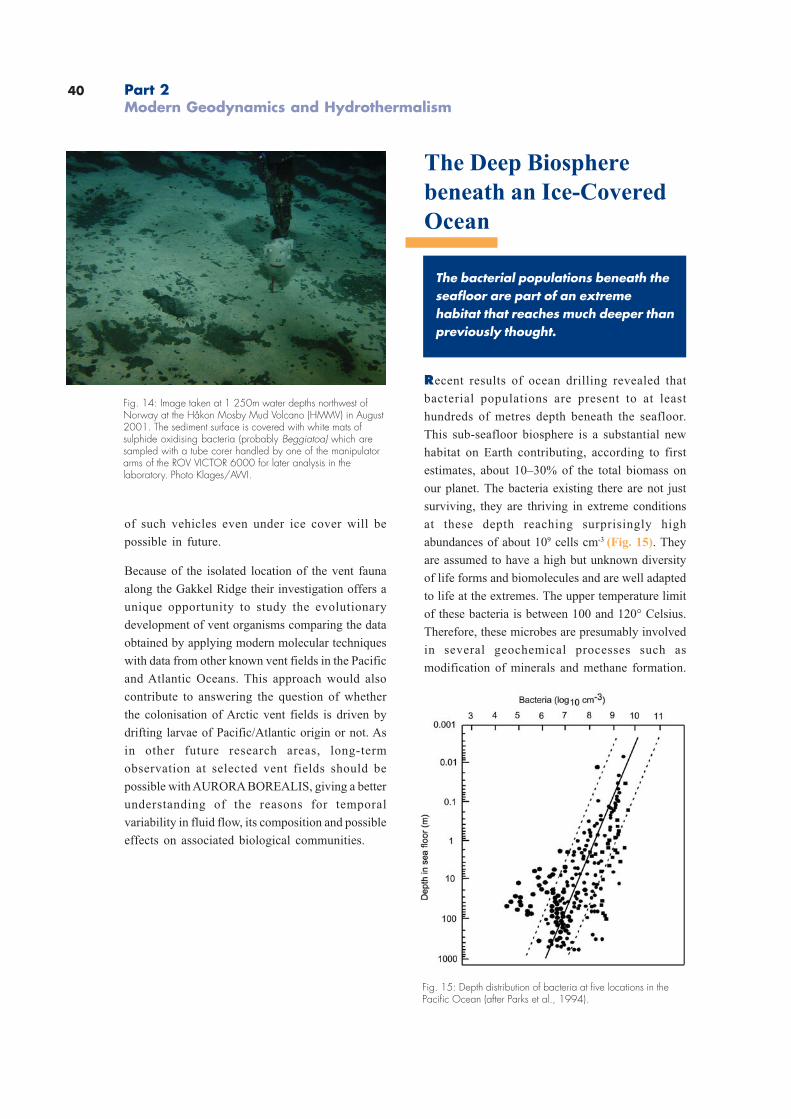
40 Part 2Modern Geodynamics and Hydrothermalism
of such vehicles even under ice cover will be
possible in future.
Because of the isolated location of the vent fauna
along the Gakkel Ridge their investigation offers a
unique opportunity to study the evolutionary
development of vent organisms comparing the data
obtained by applying modern molecular techniques
with data from other known vent fields in the Pacific
and Atlantic Oceans. This approach would also
contribute to answering the question of whether
the colonisation of Arctic vent fields is driven by
drifting larvae of Pacific/Atlantic origin or not. As
in other future research areas, long-term
observation at selected vent fields should be
possible with AURORA BOREALIS, giving a better
understanding of the reasons for temporal
variability in fluid flow, its composition and possible
effects on associated biological communities.
The Deep Biosphere
beneath an Ice-Covered
Ocean
The bacterial populations beneath theseafloor are part of an extremehabitat that reaches much deeper thanpreviously thought.
Recent results of ocean drilling revealed that
bacterial populations are present to at least
hundreds of metres depth beneath the seafloor.
This sub-seafloor biosphere is a substantial new
habitat on Earth contributing, according to first
estimates, about 10–30% of the total biomass on
our planet. The bacteria existing there are not just
surviving, they are thriving in extreme conditions
at these depth reaching surprisingly high
abundances of about 109 cells cm-3 (Fig. 15). They
are assumed to have a high but unknown diversity
of life forms and biomolecules and are well adapted
to life at the extremes. The upper temperature limit
of these bacteria is between 100 and 120° Celsius.
Therefore, these microbes are presumably involved
in several geochemical processes such as
modification of minerals and methane formation.
Fig. 14: Image taken at 1 250m water depths northwest ofNorway at the Håkon Mosby Mud Volcano (HMMV) in August2001. The sediment surface is covered with white mats ofsulphide oxidising bacteria (probably Beggiatoa) which aresampled with a tube corer handled by one of the manipulatorarms of the ROV VICTOR 6000 for later analysis in thelaboratory. Photo Klages/AWI.
Fig. 15: Depth distribution of bacteria at five locations in thePacific Ocean (after Parks et al., 1994).
41
Large bacterial populations were found in close
proximity to fossil hydrocarbon stocks suggesting
an involvement in hydrocarbon modification. In
order to get a better understanding of the processes
and organisms involved in the deep biosphere, this
discovery is one of the six explicit scientific themes
in the long-range ODP plan. The first choice for a
deep biosphere-dedicated microbiological ODP leg
in 2002 was the Peru Margin because of its
extremely organic-rich sediments which receive
high amounts of primary produced marine matter
from upwelling. A future choice for comparison
could be Arctic Ocean sediments because of the
strong environmental differences compared to an
upwelling system. Among these differences are:
1) central Arctic Ocean sediments receive less
amounts of primary produced organic matter;
2) rather low sedimentation rates were measured;
and 3) ice-rafted and riverine terrigeneous material
distinguish Arctic Ocean sediments from other
ocean sediments.
With its drilling capacity AURORA BOREALIS
would offer the unique opportunity to sample the
deep biosphere in the Arctic with its wide range of
sediment types (hemipelagic muds, black shales,
siliceous oozes and volcanic materials). With such
a technology in the background and the work on
hot vents/cold seeps in the Arctic, European
scientists would further develop their leadership
in the investigation of some of the most extreme
habitats on Earth. First sampling sites could be
selected in close cooperation with geologists
according to their drilling objectives. Some of the
main research objectives will be the investigation
of microbial methanogenesis at great sediment
depth, the identification of physiological and
phylogentic differences of bacteria including
studies on the limiting factors (temperature,
substrate, pressure, etc.) for microbial life in the
deep biosphere.
Impacts of the Siberian
Shelf Seas
The Arctic system is a sensitiveindicator of environmental changes.Understanding the evolution towardsthe present state of Arctic climate aswell as its feedback on the globalsystem is necessary to decipherprocesses controlling climatic changes.
For a simulation of future development of the Earth’s
climate after taking into account a greenhouse
effect, it is necessary to reconstruct the Arctic
environment over the very recent geological time.
The Arctic Ocean is surrounded by the largest
continental shelves on Earth (Jakobsson et al.,
2000). Being both large and shallow, these shelves
remain sensitive to sea-level fluctuations. Very
large rivers drain onto these shelves, influencing
sea ice cover and depositional environments. The
shelves, in particular the Laptev Sea and its Siberian
hinterland, are considered to constitute a key
source for the Arctic halocline’s freshwater budget
and a major ice production area, linking the Siberian
shelves to the Arctic Ocean and the Nordic seas.
There are many areas of land-sea interaction in the
Siberian Arctic about which we have little
understanding. For instance, our knowledge of the
climatic impact on sea ice formation is very limited,
making it difficult to predict possible future global
climatic changes. This holds true in particular for
the Siberian Shelf Seas (Kassens et al., 2002),
which, for logistical and political reasons, have long
been inaccessible to the international scientific
community.
Ecosystems of the coastal zone are extremely
sensitive to anthropogenic activities, which
drastically increased in scale and rate during the
last century. Commercial usage of the Northern Sea
Route, extraction of non-renewable resources,
particularly oil and gas developments, projects of
new infrastructure complexes created new types
of interaction between natural and anthropogenic
systems.
42
We need to evaluate the impact of global changes
in social and economic systems as well as the
response of economic activity and their impact on
natural systems. Such assessments will be the
scientific basis for an integrated management of
the coastal environment.
Overall Research Goals
1. Land-sea connection: present and past natural
processes on the Arctic continental margin
with particular reference to the effect of riverine
and other coastal fluxes.
2. Forcing functions: rate and degree of
environmental changes.
3. Arctic processes and climatic change:
databases and models for reconstructing the
past, understanding the present, and predicting
the future.
. Major research foci
Evaluation of the environmental variability of
the Laptev Sea Shelf polynia, in particular in
the area of the Northern Sea Route. The Siberian
river discharge is of major importance for the
Arctic and global ocean systems (Kassens et
al., 2002; Stein et al., 2003). The freshwater input
contributes significantly to a strong
stratification of the near-surface water masses
and, thus, promotes sea ice formation. Changes
in the freshwater balance would influence the
extent of the sea ice cover. The melting and
freezing of sea ice results in distinct changes in
the surface albedo, the energy balance, the
temperature, and salinity structure of the upper
water masses, and of the biological processes.
Changes in these export rates of freshwater
would result in changes of deep water formation
and, thus, in global thermohaline circulation and
ventilation. Therefore it is necessary to
understand the complex interactions in land-
estuary-atmosphere-ocean systems.
. Dynamics and history of permafrostin the Siberian ArcticPermafrost is a particularly sensitive indicator
of climate (Romanovskii, in press). Some of the
conditions affecting its formation are severe
climate, sea-level change, glaciation, and
geomorphologic change as in Arctic deltas.
The potential for climatic change will have
serious local and global consequences.
Climatic warming will influence permafrost to
varying degrees by increasing active-layer
thickness, increasing rates of peat and gas
hydrate decomposition and the subsequent
release of carbon dioxide and CH4 increasing
the amounts of thermoerosion and sediment
transport. These responses would have
secondary and tertiary affects through
changes in channel morphology and transport
of nutrients from the terrestrial system, through
the aquatic to the marine system.
. Sinks and sources of carbon andnutrients in high latitude northernEurasiaThe Arctic rivers transport large amounts of
dissolved and particulate material onto the
shelves where it is accumulated or further
transported by different mechanisms (sea ice,
icebergs, turbidity currents etc.) towards the
open ocean. Thus, river-derived material
contributes in major proportions to the entire
Arctic Ocean sedimentary and chemical
budgets. However, the sources and sinks of
carbon and nutrients from the Eurasian
watersheds to the Russian Shelf Seas is poorly
known (Stein et al., 2003).
Part 2Modern Geodynamics and Hydrothermalism
43
Seafloor Processes
with a Geological Impact
The major traits of the grossphysiographical features of the ArcticOcean are shaped by plate tectonicsand the impact of sedimentation anderosion along the seafloor. All ofthese processes are poorly known inthe Arctic and need thorough effortsof study.
We know that large amounts of fine-grained clastic
sediment materials included in sea ice as well as
coarse material, transported by icebergs, reach the
central part of the Arctic Ocean, where they
apparently melt out of the ice and rain down to the
seafloor. Neither of these properties is properly
quantified (Pfirman et al., 1990; Nürnberg et al.,
1994).
Due to the presence of permafrost, large segments
of the Arctic coasts and hinterland consisting of
ice complexes, which are currently degrading
rapidly, plus huge quantities of sediments are made
available for sedimentation either in or on the ice
or on the shelves infront of the coastal sections.
The sediments comprise high proportions of
organic materials and they are, together with the
sediment load of the river waters, transported out
to the shelf where they are distributed or re-
distributed. It is unclear how they reach the shelf
edge but the morphology of the shelves is either
characterised by the relatively recent existence of
an ice sheet generating a highly irregular
topography, or by wide, shallow shelves, which
allow the tracing of former river valleys that existed
during the last glacial maximum when sea level was
approximately 130m below contemporary levels.
Signs of erosion on ridge crests and rises have
been observed occasionally and it is yet to be
resolved if this erosion is due to the ephemeral
existence of ice shelves over the Arctic Ocean, due
to giant icebergs or due to bottom scavenging of
currents (Jacobsson et al., 2002). The erosion
processes, generated under the fast ice along the
coast and by the drifting sea ice, need to be defined
and further studied. Apparently the presence of
the ice and its erosional/depositional effects result
in a slightly different hypsograph curve of the
shallow parts of the shelf.
The deep basins of the plate tectonically young
eastern Arctic Ocean Basin and of the tectonically
old Canada Basin are covered by turbidite
sequences and the results of the slumping
processes along the adjacent continental margins;
they have yet to be quantified in terms of timing
and regional distribution. Both in the Canada Basin
as well as in the eastern Arctic Ocean turbidite
sequences are up to several thousand metres thick,
their source regions and reasonable detail are yet
to be resolved. Many of these questions have to
be addressed, probably by detailed studies to be
carried out by deep-towed tools or by seismic
reflection profiling. The currently available
database is far too scant to gain a detailed picture
of sediment distribution and their source regions
(Weber and Sweeney, 1990). It will require a
multiyear effort to establish this database and to
relate physiography of the seafloor surface as well
as sediment input to the major processes controlling
their distribution.

44
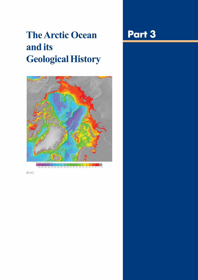
45
The Arctic Ocean
and its
Geological History
Part 3
-5500 -5000 -4500 -4000 -3500 -3000 -2500 -2000 -1500 -1000 -500 -400 -300 -250 -200 -150 -100 -50 -20 0 (m)
Bathymetric and topographic tints
IBCAO
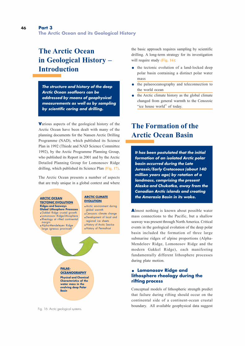
46 Part 3The Arctic Ocean and its Geological History
Fig. 16: Arctic geological systems.
the basic approach requires sampling by scientific
drilling. A long-term strategy for its investigation
will require study (Fig. 16):
. the tectonic evolution of a land-locked deep
polar basin containing a distinct polar water
mass
. the palaeoceanography and teleconnection to
the world ocean
. the Arctic climate history as the global climate
changed from general warmth to the Cenozoic
“ice house world” of today.
The Formation of the
Arctic Ocean Basin
It has been postulated that the initialformation of an isolated Arctic polarbasin occurred during the LateJurassic/Early Cretaceous (about 140million years ago) by rotation of alandmass, comprising the presentAlaska and Chukotka, away from theCanadian Arctic islands and creatingthe Amerasia Basin in its wake.
Almost nothing is known about possible water
mass connections to the Pacific, but a shallow
seaway was present through North America. Critical
events in the geological evolution of the deep polar
basin included the formation of three large
submarine ridges of alpine proportions (Alpha-
Mendeleev Ridge, Lomonosov Ridge and the
modern Gakkel Ridge), each manifesting
fundamentally different lithosphere processes
during plate motion.
. Lomonosov Ridge andlithosphere rheology during therifting process
Conceptual models of lithospheric strength predict
that failure during rifting should occur on the
continental side of a continent-ocean crustal
boundary. All available geophysical data suggest
The Arctic Ocean
in Geological History –
Introduction
The structure and history of the deepArctic Ocean seafloors can beaddressed by means of geophysicalmeasurements as well as by samplingby scientific coring and drilling.
Various aspects of the geological history of the
Arctic Ocean have been dealt with many of the
planning documents for the Nansen Arctic Drilling
Programme (NAD), which published its Science
Plan in 1992 (Thiede and NAD Science Committee
1992), by the Arctic Programme Planning Group,
who published its Report in 2001 and by the Arctic
Detailed Planning Group for Lomonosov Ridge
drilling, which published its Science Plan (Fig. 17).
The Arctic Ocean presents a number of aspects
that are truly unique in a global context and where
ARCTIC OCEANTECTONIC EVOLUTIONRidges and SeawaysGlobal Lithosphere Processes.Gakkel Ridge crustal growth. Lomonosov Ridge-lithosphere.Rheology at rifted continental
margin.Alpha-Mendeleyev Ridge
large igneous province?
ARCTIC CLIMATEEVOLUTION
.Arctic environment duringglobal warmth
.Cenozoic climate change
.Development of local andregional ice sheets
.History of Arctic Sea-Ice
.History of Permafrost
PALAE-OCEANOGRAPHY
Physical and ChemicalCharacteristics of thewater mass in theevolving deep PolarBasin
47
that the Lomonosov Ridge is a sliver of continental
crust and therefore potentially the most
outstanding example anywhere in the ocean for
testing this hypothesis.
We need to establish the nature of the crustal
framework and tectonic history of this 1 500km-
long structure by geophysical surveys and
scientific drilling. A first attempt at drilling the
Lomonosov Ridge will hopefully be attempted by
IODP in summer 2004.
. Alpha-Mendeleev Ridge– a large ingeous province or amore complex feature?
Large igneous provinces (LIPs) are accumulations
of mafic rocks formed by processes distinct from
those associated with plate movements. At times
in the past, particularly during the Cretaceous, the
mantle flux associated with the emplacement of
LIPs, may have exceeded that associated with the
global mid-ocean ridge system. Therefore, LIP
emplacement is an important factor in determining
global geochemical cycles.
The Alpha-Mendeleev Ridge, a lithosphere feature
stretching across the Arctic Ocean Basin, may
represent a Cretaceous LIP and be coeval with a
major magmatic episode in the Canadian and
Russian Arctic islands. The principal support for
this theory comes from seismic refraction studies,
which indicate a crust approximately 40km thick
with a structure similar to that of other oceanic
LIPs. However, a continental origin of parts of the
ridge is also a possibility.
The Alpha-Mendeleev Ridge needs to be sampled
by scientific drilling because of its large size
compared to other LIPs as well as its importance to
meaningful reconstructions of the Arctic Ocean
Basin.
Changes in Arctic
Hydrography
At present there are only eight rocksamples and/or short sediment cores,recovered by chance, to document theMesozoic Arctic Ocean environmentduring the initial event when theAmerasia Basin formed.
The occurrence of black shales is considered to
represent oxygen-deficient conditions along the
flanks of islands on the Alpha Ridge about 80 to 85
million years ago. Subsequently, the presence of
laminated siliceous oozes, more typical of
environments of temperate latitudes, is indicative
of an Arctic Ocean upwelling system. The second
event in the birth of the polar basin was the
formation of the Eurasia Basin, by extension of the
North Atlantic seafloor spreading into the Arctic
region between Svalbard and Greenland by about
56 million years ago. A deep teleconnection
between the Arctic Ocean and the world ocean was
established sometime after about 40 million years
ago by the opening of the Fram Strait, and today
the polar basin is part of the source region for
bottom water renewal in the global ocean. On the
Pacific side, the shallow seaway through the Bering
Strait formed after about 5.5 million years ago. The
change from a temperate Mesozoic and early
Cenozoic global environment to the modern extreme
is one of the most exciting and least understood
chapters of Earth history. In spite of our efforts so
far, a key to understanding the Mesozoic and
Cenozoic Northern Hemisphere conditions in
general, and polar palaeoceanography in particular,
is still hidden in the sedimentary sequences of the
Arctic Ocean itself.
48
Extreme Climates –
Learning from the Past
to Explain the Future
The present-day Earth is in a state ofextreme climate condition. Tounderstand how this evolved, howthis condition has been maintainedand how it might end is a researchpriority for the international scientificcommunity under the new IODP Planfor the understanding of global change.
Thermal maxima occurred during the period 120–
100 million years ago, and at about 50 million years
ago. Subsequently, the Earth’s climate gradually
went into an “icehouse” state with major shifts
taking place at about 34, 26, 14 million years ago
and 2.5 million years ago. Today, the Arctic Ocean
is the primary Northern Hemisphere heat sink and
an important challenge is to develop a qualitative
understanding of the underlying mechanisms for
maintaining polar warmth in the past. The evolution
of Northern Hemisphere glaciation is complex and
local ice sheets may have developed before 10
million years ago. A dramatic influx of ice-rafted
debris from the continents into the ocean basins
signalled an intensification of glaciation in the
north 2.5 million years ago. Recent surveys by
submarines and by sediment sampling demonstrate
that icebergs with drafts of up to 1 000 m have
ploughed furrows in the bottom sediments on top
of the Lomonosov Ridge in the central Arctic Ocean
within the last few hundred thousand years. We
still know very little about the history of sea ice
cover in the Arctic Ocean. The permanent sea ice
cover has a tremendous influence on the albedo,
atmospheric circulation, and distribution of fresh
water. New geological results from areas of high
sedimentation rates hold promise for documenting
the relative strength of the Beaufort gyre and the
Transpolar Drift on a thousand year time scale and
provide crucial insight for understanding the
variability experienced during historic times. While
the recently observed polar warming is dramatic,
the new micropaleontological data suggest that
mid-Holocene Arctic Ocean water temperatures may
have been 5°C warmer only a few thousand years
ago. Our primary challenge is to document the high
Arctic environment in time and space in order to
understand whether the Arctic Ocean influences
changes in global climate or how it responds to
these changes.
Part 3The Arctic Ocean and its Geological History
Fig. 17: Title pages of published reports of theNAD Implementation Plan, The ADPG 2001report.
49
The Stability of the
Offshore Permafrost
Terrestrial permafrost is an importantfeature of the major landmassesof the high northern latitudes.
Permafrost extends across Central Asia and central
North America far into low latitudes and seems to
have evolved as a result of the late Cenozoic climate
regime. Relatively recently large tracts of submarine
permafrost have been detected in the Arctic
Siberian Shelf Seas, which comprise former land
surfaces due to the lowered glacial sea levels
(Romanovskii, in press).
This must have occurred frequently as a
consequence of the repeated glaciations, affecting
in particular the large landmasses on the Northern
Hemisphere. Permafrost is outcropping in many
places at the modern sea surface, and the
observations of the karst phenomena in the seafloor
and of disappearing islands document the fact that
not only the terrestrial permafrost areas are
retreating quickly today but that the submarine
permafrost areas are also subject to degradation
during the modern warming.
The submarine permafrost regions and segments
have been sampled only in a few geotechnical drill
sites with no real attempts made to date the
sediments of the ice complex. Only recently has
drilling been carried out in the Laptev Sea, which
permitted the dating of the surface layers of the
submarine permafrost. C-14 ages of the surface
layers pointed to the fact that they developed
during the last glacial maximum (Kassens, personal
communication). However, very little is known
about the extension and thickness of the submarine
permafrost areas, in particular nothing much about
the timing and the processes of their formation. It
would therefore be an important task, both in terms
of paleoclimatic studies as well as in terms of
documenting the potentially occurring gas
hydrates, to investigate the structure, origin and
history of the submarine permafrost regions and
to compare the features with their terrestrial
counterparts. Little can be achieved without having
research vessels with a substantial drilling
capability at the disposal of the researchers.

50
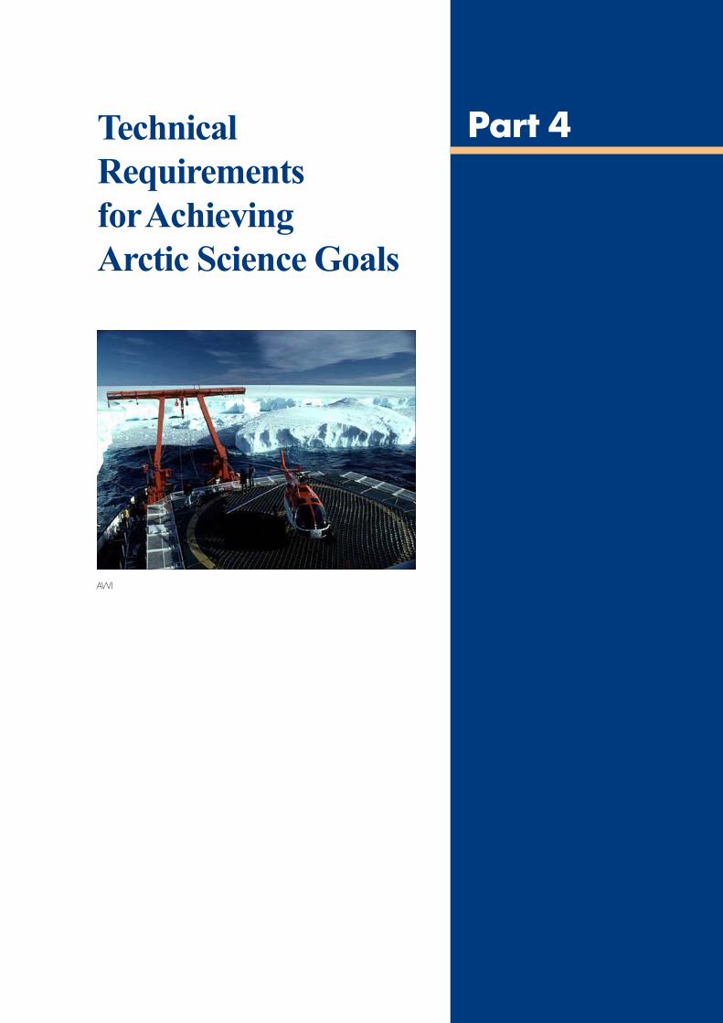
51
Technical
Requirements
for Achieving
Arctic Science Goals
Part 4
AWI
52
Technical Requirements
for Achieving Arctic
Science Goals
– Introduction
The scientific necessity and the general research
requirements for the AURORA BOREALIS project
are demonstrated in Parts 1-3 of this report, which
provides a scientific vision and justification for a
unique infrastructure solution. The project calls
for a multipurpose all-season icebreaking
research vessel with a drilling capability.
The vessel should be able to support experiments
for all existing marine disciplines: physical
oceanography, biological oceanography, marine
geology (including drilling), sea- and air-chemistry,
marine geophysics, meteorology and more. As a
multipurpose vessel specific equipment will be
installed only if it cannot be supplied within
specific lab-containers. This implies sufficient
space and supplies (water, electricity, data and
more). Furthermore it has to be ensured through a
modularised construction that future
modernisation of the ship and equipment will be
as easy as possible.
An absolute condition for such a multipurpose
icebreaking research vessel is a very good
manoeuvrability on transit as well as on station
within open and ice-infested waters – without
additional icebreaker assistance. This includes
dynamic positioning in open and ice-covered
waters and the ability of slow motion for longer
time periods. The ship has to be economical,
reliable, vibration-free, of low-noise and hydro-
acoustically silent.
In a global sense there is no research icebreaker
of the required power and capacity available for
carrying out year-round scientific missions within
the Arctic Ocean. And there is currently no vessel
strong enough for drilling and operating
automatically in ice-covered waters, such as the
central Arctic Ocean. Even when assisted by
icebreakers any drill-ship must have a highly ice-
strengthened hull to resists the ice pressure of the
central Arctic conditions.
This requires the development of a new, tailor-made
multipurpose research platform with state–of-the-
art equipment such as that proposed in the
AURORA BOREALIS project described in more
detail below. The scientific requirements of this ship
are unique in that the propsed tasks currently
cannot be performed from any other research
platform in the world. The planning and the final
construction therefore implicate different technical
solutions: 1) new developments, which should be
tested as far as possible beforehand, for example
within a study for tendering the ship’s
construction; 2) developments and the potential
of existing technical features; and 3) state-of-the-
art technical features, as found on already-existing
scientific platforms. In the list below all
requirements are listed and graded with ND – new
development, DT – development of existing
technical facilities and SA – state-of-the-art
technical aspects.
Mission Types for the
AURORA BOREALIS
As outlined in the science part of this perspective,
there is a wide variety of scientific disciplines
requiring a range of technical capabilities from this
ship, which in general has to be powerful enough
to operate year-round in the central part of the Arctic
Ocean as well as be able to maintain station by
dynamic positioning. Several mission types can
be envisaged as deduced from the scientific
requirements outlined above:
. Summer missions to the Arctic Ocean, fordrilling, for site surveying and for classicalpolar research disciplines. The ship will be
operating in any waters encountered, both ice-
covered and open water, and will have to be
able to use its dynamic positioning system and
to traverse areas of old ice (that is to say with
the mean thickness of 2m and more). The
duration of such missions can be from 2 to 3
months.
Part 4Technical Requirements for Achieving Arctic Science Goals
53
. Summer missions purely for drilling. The
main use during the optimal ice season will be
devoted to carrying out the drilling programme
as a mission-specific platform for IODP. This
will require outfitting the ship with a removable
drilling rig, which has to be protected against
bad weather and with a suite of laboratories
dedicated to the drilling task. The ship needs
to carry provisions in terms of fuel and food
(for the increased equipment and personnel
devoted to science and drilling), as well as lab
supplies.
. For winter, autumn and spring missions tothe central part of the Arctic Ocean. These
missions will be mostly devoted to the classical
polar research disciplines, requiring a floating
platform. Some of the disciplines have indicated
that they may have substantial use for the lifting
capabilities of a derrick and this has to be
evaluated if the drilling derrick is removed
during each winter season. The ship will be
equipped with the mission-specific suite of
laboratories and it will be operating in any Arctic
waters even under heavy ice conditions.
. Year-round mission in the Arctic Ocean. At
the present time no plans have been developed
for a long-term deployment (more than 6 to 12
months) for a ship in the Arctic. Such missions
may be needed in the future for Arctic
exploration and the ship needs to fulfil its
scientific requirements for such missions.
. Year-round missions in the Atlantic Ocean.The AURORA BOREALIS will also be used as
a regular research vessel in ice-margin areas
and it needs a reasonable transit speed and
securing behaviour (roll-damping devices) as
well as dynamic positioning.
. Antarctic missions. At the present time the
AURORA BOREALIS is thought of as a
dedicated Arctic research vessel in use for a
decade or more. However, if urgent scientific
need arises and if the members of the AURORA
BOREALIS consortium are willing to devote
its ship-time to the Antarctic, it should be able
to fulfil the technical requirements of Antarctic
research work too. They will be rather similar to
the Arctic requirements with the exception that
the seas of the Southern Ocean are rougher. A
particularly attractive aspect is that the
AURORA BOREALIS will be able to address
Antarctic deep sea drill sites, which cannot be
reached by either the classic type of JOIDES
Resolution operation or by a system like the
Cape Roberts Project (CRP) system, which
operates from the sea ice.
Technical Requirements
for Marine Geophysics
Marine geophysical surveys and conventional
gravity- and giant piston coring (for example with
the French Calypso-system) are a prerequisite to
selection of optimum sites for scientific drilling.
Site definition often requires several seasons of
data collection and is urgently needed for
justification of a long-term scientific drilling effort
in the Arctic Ocean. Foremost, we need to further
develop the, technically difficult task of seismic
data acquisition from a single vessel to the point
where it can be done at maximum propulsion
capacity of the vessel with minimum loss of
scientific equipment.
The need for a substantial effort to acquire
geophysical regional and site survey data was
established at a JEODI workshop in Copenhagen
in January 2003 (see Appendix II). The site surveys
will either cover new regions or will refine and look
for new targets based on the drilling results gained
with AURORA BOREALIS. The ship must therefore
also have the ability to carry out geophysical
investigations (seismic reflection and refraction,
gravity, magnetic, swath bathymetry mapping
system, sediment echo sounder). This includes
facilities for remotely operated vehicle (ROV)
deployments for precise bottom sampling.
54
Alternative Solutions
There are naturally a limited number of alternative
solutions to fulfil the requirements of the science
as defined in Parts 1-4 of this Science Perspective.
For example, heavy duty icebreakers can be
adapted to scientific work, commercial drilling
platforms can sail (or be towed) into the central
Arctic under substantial icebreaker assistance, etc.
None of these solutions can match a new, dedicated
research icebreaker with a deep drilling capability
because they:
. will lead to occasional peaks in research efforts
in the Arctic, but not to a substantial and
continuous, uninterrupted science effort in the
central Arctic
. do not comprise the novel technology needed
for an effective execution of the envisaged
research programme
. do not guarantee the long-term commitment to
support a substantial and dedicated drilling
effort in the Arctic deep sea
. do not lead to the establishment of substantial
research programmes devoted to the central
Arctic.
Technical Requirements
for a High Arctic Drilling
Vessel
The principal requirement is an icebreaking research
vessel with the ability to operate in the high, ice-
covered Arctic. It must be equipped with a drill rig,
heave compensation system, a moon pool, and
dynamic positioning. The rig should be able to
support a drill string for continuous coring down
to 1 000m below the seafloor, ideally in water depths
of 3 000m.
The main requirement is a ship with icebreaker
capability, equipped with a moon pool, precise
dynamic positioning, a drilling system, and
excellent heave compensation. Successes in the
Cape Roberts Project, where core recovery, even
Part 4Technical Requirements for Achieving Arctic Science Goals
in poorly consolidated strata was well in excess of
90%, showed the value of having an effective riser
system.
In the Antarctic, wherever one might be drilling at
sea, there must be concerns about interference from
icebergs. This applies in the Arctic to a far lesser
degree. Therefore, time in the hole should be kept
to a minimum. Existing seismic surveys reveal
extensive gently dipping sequences that would
lend themselves to investigation by a series of short
holes(few hundred metres) sited down-dip and
with stratigraphic overlap.
A state-of-the-art wireline logging facility is critical
to achieving the best possible correlation between
holes, as well as providing information on any
sections lost in the coring.
With careful selection of sites and targets, the ability
to drill to 500m or more below the seafloor would
open up enormous possibilities.

55
AURORA BOREALIS
Conceptual Study
A preliminary conceptual study by HSVA showed
the general feasibility of the required icebreaking
research platform as well as its ability to operate in
the central Arctic without additional icebreaker
assistance. The main feature of the study is a new
hull with strong sloped side walls for sideways
breaking during dynamic positioning in ice-covered
waters (Fig. 18). The main features and some
important particulars are listed below and graded
ND, DT and SA whenever necessary and possible.
Fig.18: Cross section of AURORA BOREALIS.Note: (1) the sloped side walls for sidewards ice-breakingduring dynamic positioning in ice-covered waters, (2) thedouble hull for safety of the ship, (3) the derrick with the upperpart removable or retractable.
. Main dimensions. Length between perpendiculars Lpp 132.0m. Beam (main deck) 40.0m. Beam CWL 36.0m. Draft CWL 8.5m. Depth to main deck 13.5m. Max. displacement approx. 2 3000.0 tonnes. Ice-class as high as possible (ND)
. Mission profile. Endurance at of total
installed power 18000nm (DT). Duration 60 days (DT). Max. speed 15kn (DT). Cruising speed 12kn (DT. Minimal speed 0 – 2kn (DT). Personne total 200 persons. Fuel Capacity approx. 6000
. Icebreaking performance. Ahead and astern icebreaking
(winter ice) 1 Knot >2.0m (DT). Dynamic positioning in ice-covered
waters (slow-motion ice-breaking) (ND)
. Nautical equipment. 2 radars (SA). GPS/Glonass (SA). Sonar (SA). Speed log (SA). Clinometers (SA). Gyro and necessary nautical instruments (SA). Ice-forecasting system (DT)
. Hull design. New hull with strong sloped side walls for
sidewards icebreaking during dynamicpositioning with both sterns optimised foricebreaking and open water operations (ND)
. Low noise possibility for seismic work (DT)
. Channel-clearance behind the ship forseismic work (DT)
. Twin hull, ballast or void space for safety reasons (DT)
. Minimum two compartment vessel for safetyreasons (DT)
. Helicopter deck and hangar (SA)
. Special painting (‘green ship’) or stainless steelplated hull (DT)
. Survivability compartment inside the vessel
. Working deck area covered (DT)
56 Part 4Technical Requirements for Achieving Arctic Science Goals
. Machinery
. Diesel electric (see Fig. 19) (SA)
. Diesel generators 6 x 5 MW (SA)
. Diesel generators 4 x 2.5 MW (SA)
. Total installed power 50 MW (SA)
. Redundancy (minimum two engineand two control rooms) (SA)
. Closed (or partly closed) cool water systems (DT)
. Emissions as low as possible (DT)
. Vegetable oil for lubrication and hydraulics (DT)
. Closed water system for grey water (DT)
. Combustion plant (DT)
. Propulsion
. Azimuth propulsion at the stern 2 x 25 MW (ND)
. Ice-strengthened retractableazimuth bow thrusters 3 x 3 MW (ND)
. Total installed propulsionand thruster power 35 MW (ND)
. Dynamic positioning DP Class 3 (DT)
. Redundancy for propulsion system (SA)
. Safety
. Water-independent fire protection system (DT)
. Rescue satellite (lifeboats) for evacuationon a minimum of one-week survival (SA)
. 4 x 50-person lifeboats, closed, ice resistant (SA)
. Inflatable liferafts (SA)
. Multipurpose research (Fig. 20)
. Laboratory and electronic areaapprox. 2300m2 (SA)
. Containers (laboratory or storage) 30 (DT)
. Supply for lab-containers(water, electricity, communication) (SA)
. General labs (wet, dry, chemistry) (SA)
. Remote operating vehicle (ROV) handling (DT)
. Autonomous underwater vehicles (AUV) (DT)
. Moon pool (Vehicle and others) 6 x 6m (SA)
. Moon pool clean up system to avoidice inside (ND)
. Side-ramp for ascent onto ice (DT)
Fig. 19: Side-view of AURORA BOREALIS: Note: (1) covered working deck aft area with sliding beam, (2) azimuth propulsion at stern,azipod with one propeller counting forward during normal operations, turned astern during transit in shallow waters,(3) retractable bow thruster, (4) both sterns optimised for icebreaking and open water operations, (5) derrick with automatic pipe supply.
Fig. 20: Engine deck. Note (1) two large moon pools, (2) redundant machinery, (3) machinery in smaller units for economicalperformance, (4) huge laboratory section.
57
Fig. 21: Working deck. Note: (1) three ship sections from bow to aft: accommodation, science and drilling (machinery),(2) automatic pipe-storage, (3) huge working deck space, (4) large laboratory space, e.g. for lab-containers.
. Drilling
. Core drilling (max. 4 000m water depthand 1 000m core) (DT)
. Removable or lowered derrick (ND)
. Reconnectable drilling pipe system (ND)
. Automatic pipe rack (SA)
. Automatic pipe lift (SA)
. Pipe store capacity about 9000m (SA)
. Height of derrick approx. 62m (SA)
. Heave compensation system (DT)
. Moon pool (drilling) 7 x 7m (DT)
. Moon pool clean up system to avoidice inside (ND)
. Storage for Cores (SA)
. ‘Calypso coring system’ (DT)
. Option for slim-line riser system (ND)
. Winches
. Friction winch 18mm Ø 6 000m (SA)(glass fibre)
. Friction winch 18mm Ø 6 000m (SA)(cable)
. Friction winch 18mm Ø 6 000m (SA)(wire)
. 2 cable winches 11mm Ø 6 000m (SA)
. Several working winches 12mm Ø 4 000m (SA)
. Capstan (SA)
. Heave compensation system (DT)
. Lifting device
. Sliding beam (stern) (DT)
. 2 sliding beams (starboard) (SA)
. 2 cranes on deck, range 30m, 25 tonnes (SA)
. Echosounding, data aquisition anddistribution. Seabeam (SA). Penetr. Echosounder (SA). ADCP (SA). Real-time data acquisition
(ship data, meteorology, echosounder and more) (DT). Real-time, fast data transmission system to and from
on-shore labs (DT)
Living Quarters (SA). Cabins
(for one and two persons with shower and WC). Conference room. Mess room. Cafeteria. Pantry and galley. Hospital. Sauna, pool and gym
58 Part 4Technical Requirements for Achieving Arctic Science Goals
Special Technical
Aspects of AURORA
BOREALIS
The requirements for hull design and testing of a
new hull shape that allows turning in ice-covered
waters has been described above. However, there
are a number of technical requirements, deduced
from the scientific demands, that are novel for
research vessels and which require a special
feasibility study, which will be carried out in the
near future. They comprise the following points:
. stability, no-vibration (to permit the on-board
use of sophisticated equipment, e.g. “floating
floor” labs)
. “Class 100” clean laboratory
. controlled laboratories for the use of radio-
isotopes
. no (or minimised) interference for optical
measurements (ship paint colour)
. deep freezing cells
. capability to deploy and recover long and
heavy moorings
. slow motion capability
. “clean” electrical power (dedicated scientific
line)
. on-board Local Area Network
. real-time, fast data transmission system to
and from on-shore labs, remote sensing
images, etc.
. capability to manage heavy packages, such
as benthic observatories, etc.
Development of an ice-strengthenedpowerful azipod propulsion system
The requirements of the dynamic positioning
and of station-keeping against a slowly floating
sea ice mass require a very powerful ship and a
specific hull-shape as described above.
Directional bow thrusters (or azipods) may have
to be retractable.
Development of a removable derrick
Derricks for drill-ships are routinely used – as
known from many examples. However, in this
instance they will have to be used under very harsh
climatic conditions, requiring protection against
weather for the crew operating the derrick. Several
scientific disciplines other than deep sea drilling
also requested access to the lifting capacity of the
derrick. The derrick should be removable because
the ship will be devoted to drilling in the Arctic
only during the most favourable season of the year
(probably 4 months during the summertime). In
general it is envisaged that established IODP
technology is transferred to the AURORA
BOREALIS without a major need for development.
At the present time penetration into the seafloor of
no more than 1 000m (probably in most cases only
up to 500m into the sediments in the shallow parts
of the ocean crust) is predicted. No re-entry is
planned at the present time. Most of the drilling
will be done in a riserless mode, applying APC-
coring or rotary drilling coring.
A close collaboration between IODP and ICDP is
under development. Part of the ICDP community
has asked whether a removable derrick of the
AURORA BOREALIS could potentially also be
deployed for ICDP drill science, either in shallow
water from barges or even on land. This technical
problem has to be solved by the proper specialists.
Long sediment cores
A tool, close to the achievements of Arctic deep
sea drillings, has been developed in France and in
other countries by means of giant piston coring
devices. The AURORA BOREALIS should have
the technical facilities to deploy the French
Calypso-system, which will in the near future
expand its capabilities to 100m seafloor penetration.
Since many of the stratigraphic targets in the Arctic
Ocean can be approached by a step-wise
deployment of such a coring device, AURORA
BOREALIS will have to fulfil the technical
requirements of being able to deploy this set of
instruments.
59
Classical Polar Research
Sixty to seventy percent of the ship time of the
AURORA BOREALIS will be devoted to classical
polar research disciplines, requiring a floating
platform as their base. The AURORA BOREALIS
will therefore have to be equipped as a helicopter
base to permit the deployment of helicopters for
research purposes. It also has to fulfil the entire
suite of geophysical requirements for conducting
site surveys and other geophysical research, and
it has to accept the winches needed to deploy
classical marine polar research instrumentation.
This includes all kinds of probes for physical
oceanography, the ability to deploy moorings of
various natures and to take geological and
biological samples.
Moon pools
A drill ship requires a moon pool of substantial
size. Several disciplines have in addition, asked for
a second separate moon pool to deploy ROVs and
AUVs under controlled conditions. The size of the
moon pools has to be adapted to the requirements
of drilling and deployment of these instruments.
Henceforth, the dimensions will be in the order of
5 x 5 metres.
Laboratories
The AURORA BOREALIS will be equipped with a
suite of mission-specific, modularised and
containerised laboratories. This requires the
development of an entire lab-system as well as
technical facilities to store the suite of labs on a
research vessel devoted to very harsh climatic
environments. As a polar vessel, AURORA
BOREALIS will have to be equipped with
substantial cold storage, cold (climatised)
laboratories and temperature-controlled
experimental laboratories (aquaria) for marine
biological investigations.
There has been an evaluation of the minimal
requirements of lab spaces devoted to the mission-
specific activities of IODP (see the ODP Working
Group report):
Excerpt from [ODP SciMP] Working Groupreport
”SciMP considers that the minimum laboratory needsfor IODP alternate drilling platforms can be met bytwo 20-foot [approx. 6m] vans that are configured sothat they can be used either on the drilling platformsor on nearby drilling-support sites.
Van 1 - Core handling, MST, and specialsamplingFunctions:1. Core sectioning; sampling for density, head-
space, and pore-water analysis2. Whole-core MST measurements (ephemeral
properties)3. Clean sampling for microbiology…
The equipment and facilities required for thesefunctions, consisting of an MST, a glove-box, acore-sectioning stand, and related materials,would fully fill one 20-foot [approx. 6m]laboratory van.
Van 2 - Safety, drilling decisions, andephemeral propertiesFunctions:1. Head-space gas analysis (dril l ing safety,
ephemeral property)2. Micropaleontology (drilling age control)3. Pore-water analysis (ephemeral property)4. Microbial sample fixing (ephemeral property)5. Moisture and density measurements (ephemeral
properties)
The equipment and facilities required for thesefunctions, consisting of a gas chromatograph, anoven, a balance, a pycnometer, microscopes,sediment squeezers, titrators, a spectrophotometer,and associated materials, would fully occupy one20-foot [approx. 6m] laboratory van.
General requirementsBoth vans should be able to accommodate twopersons/shift (van No. 2 may require three personsper shift) and will need to be fully equipped withelectricity, running water (hot and cold), climatecontrol, and good ventilation (and both a fume hoodand an acid hood for van No. 2). Ideally, the vansshould be connected together so that sample flow isfacilitated.
At least one additional laboratory van may oftenbe required for leg-specific objectives.Furthermore, a refrigerated van may also berequired for core and sample storage, and somesamples may need to be frozen for later study ofsensitive properties soon after core sectioning.”
60
Environmental Impact
and Protection
The Arctic environment has a particular sensitivity;
it is subject to rapid changes, and its living biota
could be affected by human intervention. Using
the modern technologies available, utmost
attention must be paid to reducing the
environmental impact of a ship such as the
AURORA BOREALIS operating in the Arctic. This
means that it needs a specially protected hull so
that its emissions of all kinds (air, exhaust, water
and waste, acoustic noise) are kept to a minimum.
Justification for a
Technical Feasibility
Study
It is clear, after the preliminary results of the
conceptual study on the AURORA BOREALIS, that
a detailed technical feasibility study for planning
the vessel is urgently needed. Ideally this should
be part of a tendering process. The study is
necessary to assess the potential of such a ship to
accommodate the technical requirements deduced
from the envisaged science programmes. It is also
necessary from the point of view of trying to secure
the most modern and efficient solutions to a number
of technical aspects of a drilling vessel operating
in the Arctic, which have never been addressed
before. It would be particularly important to
demonstrate that the vessel really can operate
autonomously without assistance from additional
icebreakers because this would give it a substantial
financial advantage. However, science programmes
and drilling operations cannot be compromised
because of this aspect. Therefore technical
solutions have to be found by engineers
experienced in planning and constructing
icebreakers.
Part 4Technical Requirements for Achieving Arctic Science Goals
61
Planning,
Financing and
Management of
a Dedicated
European Arctic
Research Platform
Part 5
-4000
Bathymetric and topographic tints
-3000 -2500-2000-1500-1000 -500 -200 -100 -50 0 50 100 200 300 400 500 600 700 800 1000 (Meters)-25 -10
IBCAO
-5000
62
Planning, Financing and
Management –
Introduction
Many of the arguments collected inthis report call for a large powerfulnovel research icebreaker with adrilling capability.
The principal questions to be answered are:
. Should Europe have a coordinated polar
research programme in the Arctic (as well as in
the Antarctic)?
. Should we have tools allowing us to do
research in the most extreme environments and
during the most extreme seasons?
. And if so, is the time ripe for a large-scale
international, interdisciplinary effort in the
central Arctic?
. And is the topic of Arctic deep sea drilling
important enough to warrant the large-scale
effort of establishing a decadal drilling
programme (which also means great expense in
preparative work to define drill sites)?
(which also means great expense in preparative
work to define drill sites)?
The extensive perspectives articulated in this
document suggest that there is sufficient
justification that all of these questions can be
answered in the affirmative. Therefore the main
conclusion of this report is to move ahead with
trying to establish a new, technically novel research
tool that will allow a substantial effort in the central
Arctic Ocean, such as the AURORA BOREALIS
project.
Part 5Planning, Financing and Management of a Dedicated European ArcticResearch Platform
The Concept of the
AURORA BOREALIS
within EPB
EUROPOLAR
The AURORA BOREALIS would be the first only
European (jointly owned and run) research vessel
dedicated to Arctic research. It would require the
establishment of a management structure in Europe
and a clear distribution of responsibilities.
Following the publication of this Science
Perspective an implementation consortium would
be formed of interested nations. If substantial
interest from non-European Arctic countries
materialises, we should be open to a wider
international participation. The implementation
consortium would be tasked to generate a business
plan and structures for establishing the scientific
parties of interdisciplinary/multidisciplinary
programmes involving international science parties.
It would have the task of looking at the ship time
allotments and to oversee the management of the
facility in association with the ESF European Polar
Board’s evolving European polar entity
EUROPOLAR. It would require taking steps to
harmonise polar capabilities in the European
Research Area, the establishment of segments of a
European structure streamlining European polar
capabilities. The European Polar Board is
developing this approach through a number of
elements which comprise:
. EIMOCA(European Ice Management ObservationCapability),
. EPICOM(European Polar Infrastructures Committee),
. ERICA(European Research Icebreaker Capability),
. EPAC (European Polar Air Capability), etc.
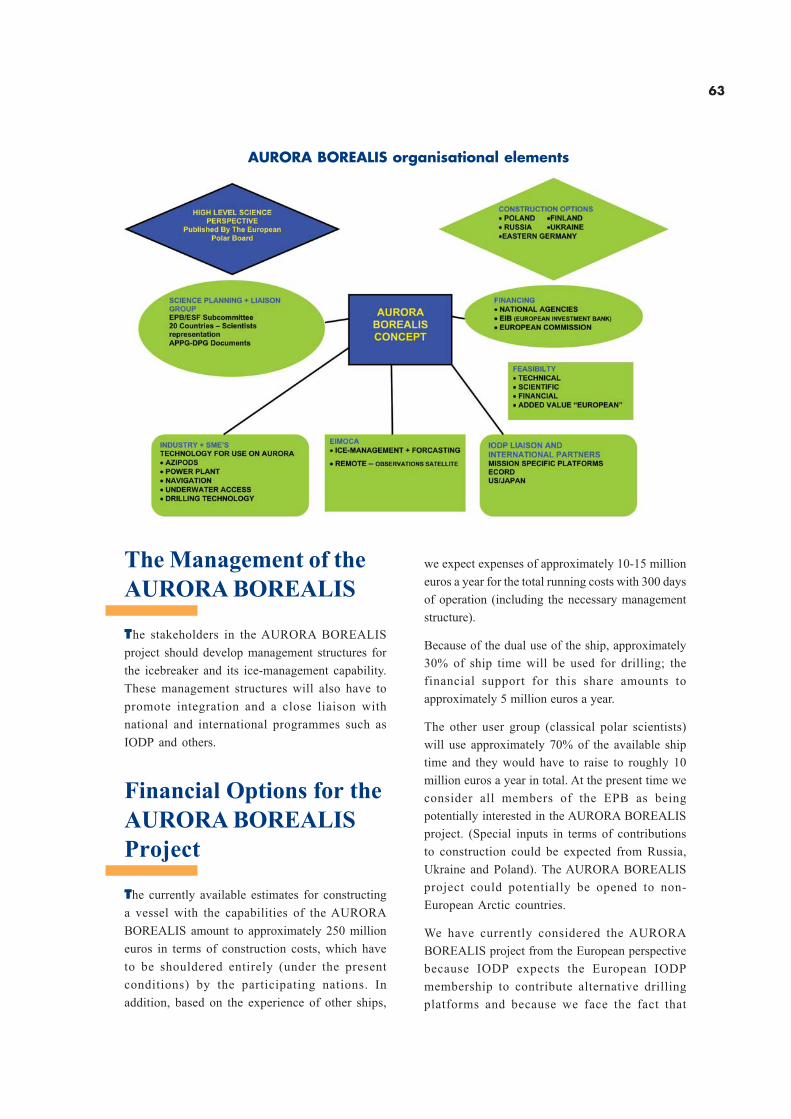
63
The Management of the
AURORA BOREALIS
The stakeholders in the AURORA BOREALIS
project should develop management structures for
the icebreaker and its ice-management capability.
These management structures will also have to
promote integration and a close liaison with
national and international programmes such as
IODP and others.
Financial Options for the
AURORA BOREALIS
Project
The currently available estimates for constructing
a vessel with the capabilities of the AURORA
BOREALIS amount to approximately 250 million
euros in terms of construction costs, which have
to be shouldered entirely (under the present
conditions) by the participating nations. In
addition, based on the experience of other ships,
we expect expenses of approximately 10-15 million
euros a year for the total running costs with 300 days
of operation (including the necessary management
structure).
Because of the dual use of the ship, approximately
30% of ship time will be used for drilling; the
financial support for this share amounts to
approximately 5 million euros a year.
The other user group (classical polar scientists)
will use approximately 70% of the available ship
time and they would have to raise to roughly 10
million euros a year in total. At the present time we
consider all members of the EPB as being
potentially interested in the AURORA BOREALIS
project. (Special inputs in terms of contributions
to construction could be expected from Russia,
Ukraine and Poland). The AURORA BOREALIS
project could potentially be opened to non-
European Arctic countries.
We have currently considered the AURORA
BOREALIS project from the European perspective
because IODP expects the European IODP
membership to contribute alternative drilling
platforms and because we face the fact that
AURORA BOREALIS organisational elements
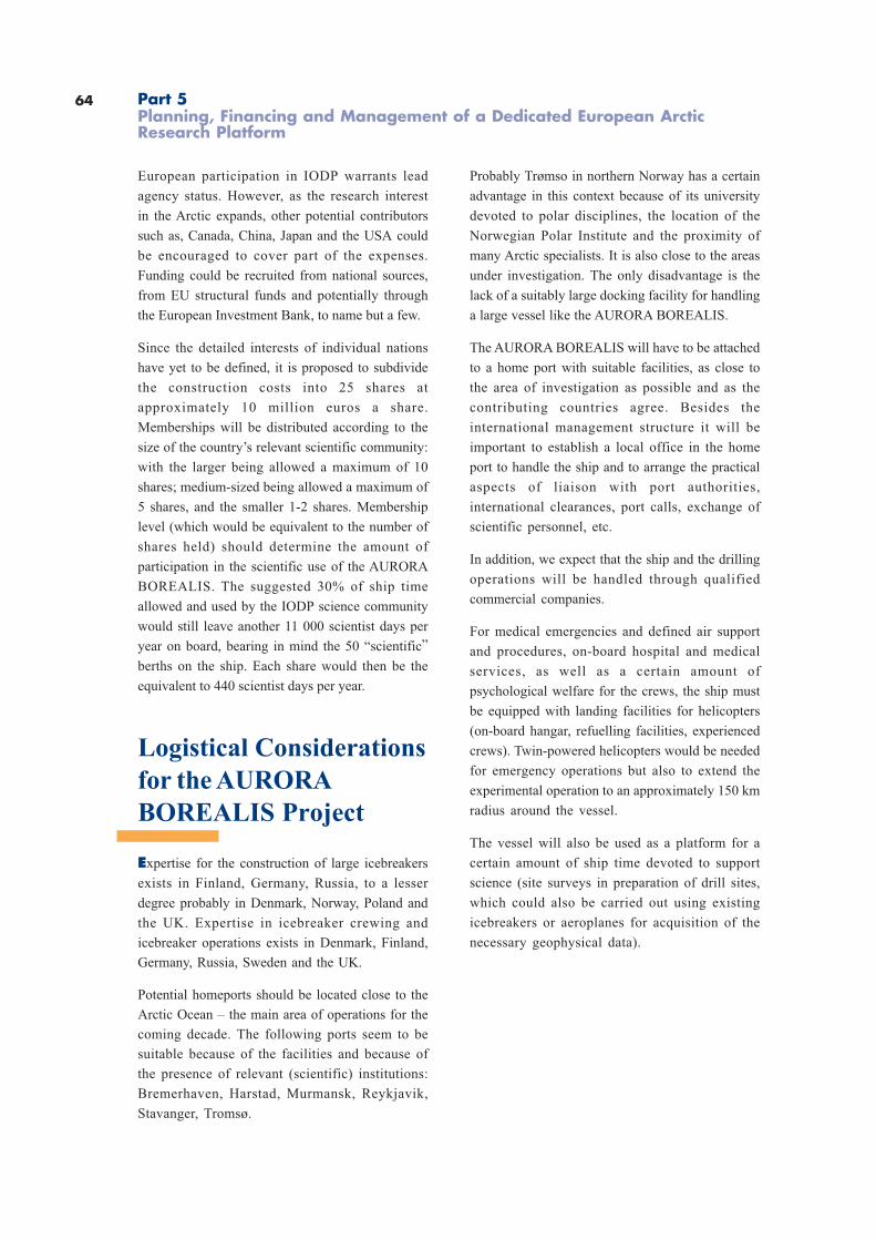
64
European participation in IODP warrants lead
agency status. However, as the research interest
in the Arctic expands, other potential contributors
such as, Canada, China, Japan and the USA could
be encouraged to cover part of the expenses.
Funding could be recruited from national sources,
from EU structural funds and potentially through
the European Investment Bank, to name but a few.
Since the detailed interests of individual nations
have yet to be defined, it is proposed to subdivide
the construction costs into 25 shares at
approximately 10 million euros a share.
Memberships will be distributed according to the
size of the country’s relevant scientific community:
with the larger being allowed a maximum of 10
shares; medium-sized being allowed a maximum of
5 shares, and the smaller 1-2 shares. Membership
level (which would be equivalent to the number of
shares held) should determine the amount of
participation in the scientific use of the AURORA
BOREALIS. The suggested 30% of ship time
allowed and used by the IODP science community
would still leave another 11 000 scientist days per
year on board, bearing in mind the 50 “scientific”
berths on the ship. Each share would then be the
equivalent to 440 scientist days per year.
Logistical Considerations
for the AURORA
BOREALIS Project
Expertise for the construction of large icebreakers
exists in Finland, Germany, Russia, to a lesser
degree probably in Denmark, Norway, Poland and
the UK. Expertise in icebreaker crewing and
icebreaker operations exists in Denmark, Finland,
Germany, Russia, Sweden and the UK.
Potential homeports should be located close to the
Arctic Ocean – the main area of operations for the
coming decade. The following ports seem to be
suitable because of the facilities and because of
the presence of relevant (scientific) institutions:
Bremerhaven, Harstad, Murmansk, Reykjavik,
Stavanger, Tromsø.
Probably Trømso in northern Norway has a certain
advantage in this context because of its university
devoted to polar disciplines, the location of the
Norwegian Polar Institute and the proximity of
many Arctic specialists. It is also close to the areas
under investigation. The only disadvantage is the
lack of a suitably large docking facility for handling
a large vessel like the AURORA BOREALIS.
The AURORA BOREALIS will have to be attached
to a home port with suitable facilities, as close to
the area of investigation as possible and as the
contributing countries agree. Besides the
international management structure it will be
important to establish a local office in the home
port to handle the ship and to arrange the practical
aspects of liaison with port authorities,
international clearances, port calls, exchange of
scientific personnel, etc.
In addition, we expect that the ship and the drilling
operations will be handled through qualified
commercial companies.
For medical emergencies and defined air support
and procedures, on-board hospital and medical
services, as well as a certain amount of
psychological welfare for the crews, the ship must
be equipped with landing facilities for helicopters
(on-board hangar, refuelling facilities, experienced
crews). Twin-powered helicopters would be needed
for emergency operations but also to extend the
experimental operation to an approximately 150 km
radius around the vessel.
The vessel will also be used as a platform for a
certain amount of ship time devoted to support
science (site surveys in preparation of drill sites,
which could also be carried out using existing
icebreakers or aeroplanes for acquisition of the
necessary geophysical data).
Part 5Planning, Financing and Management of a Dedicated European ArcticResearch Platform
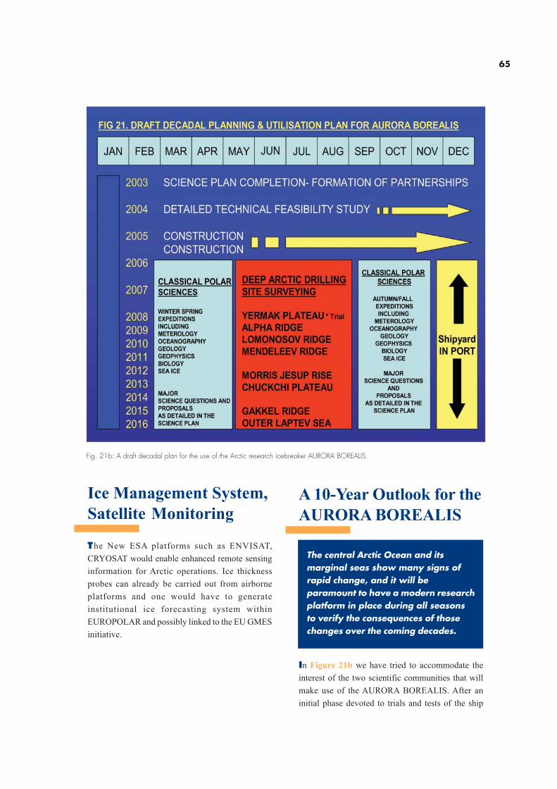
65
Ice Management System,
Satellite Monitoring
The New ESA platforms such as ENVISAT,
CRYOSAT would enable enhanced remote sensing
information for Arctic operations. Ice thickness
probes can already be carried out from airborne
platforms and one would have to generate
institutional ice forecasting system within
EUROPOLAR and possibly linked to the EU GMES
initiative.
Fig. 21b: A draft decadal plan for the use of the Arctic research icebreaker AURORA BOREALIS.
A 10-Year Outlook for the
AURORA BOREALIS
The central Arctic Ocean and itsmarginal seas show many signs ofrapid change, and it will beparamount to have a modern researchplatform in place during all seasonsto verify the consequences of thosechanges over the coming decades.
In Figure 21b we have tried to accommodate the
interest of the two scientific communities that will
make use of the AURORA BOREALIS. After an
initial phase devoted to trials and tests of the ship
66
and its technical/scientific facilities the summer
season (approximately 3 months) would be devoted
to drilling operations following the priorities of the
NAD Science Plan and of the report of the JOIDES
Arctic Program Planning Group (chaired by A.
Hovland, published in 2001). The other seasons
would be used according to the ideas developed
in this Science Perspective. The AURORA
BOREALIS with its power, structural endurance
and flexibility to accommodate different science
programmes will be a support platform for acquiring
data during the seasons of the year and from areas
in the central Arctic Ocean that have been
impossible to reach before.
Part 5Planning, Financing and Management of a Dedicated European ArcticResearch Platform

67
Appendices
68
Excerpt from WR conclusions
…..In the context of global warming and global change, the Arctic regions are the most sensitive to
climatic change. Understanding these regions is essential to predicting the evolution of the climate
system, the detection and attribution of climate change and its impacts on the European and global
environment. Unlocking the history of this region currently contained in sediment cores as well as an
accurate description of present ocean and sea ice conditions in the Arctic Ocean and their evolution will
underpin this understanding. AURORA BOREALIS is currently the only proposal that will allow the
collection of the necessary ocean cores and year-round ocean observations…..
….AURORA BOREALIS is a unique, technically innovative and very challenging project with the goal of
deploying a scientific platform for all seasons in the polar region, especially in the Arctic Ocean. The
European drilling research icebreaker would satisfy the needs of a drilling ship and a multidisciplinary
polar research vessel. There is no other ship of the capabilities proposed for AURORA BOREALIS that
would be able to conduct investigations in all seasons. The vessel would be a welcome addition to the
proposed IODP. This would open the use of the ship to the international community beyond Europe.
The drilling research icebreaker would have a paramount importance for a better understanding of
the paleoclimate, the present and the future climate, both regionally and globally…..
Appendix I
The Development of the Science Perspective
The project started to develop a science perspective after
a short technical feasibility study on the possibility of
deep sea drilling from an icebreaker had been completed.
The study was carried out by the Hamburg Ship Model
Basin (HSVA Hamburg) and resulted in the conceptual
design of the AURORA BOREALIS (Fig. 1). This study
offered a rough estimate of the size and nature of the
ship, novel technologies such as ROV and AUV systems,
dynamic positioning, propulsion and moon pools installed
in a new heavy-duty research icebreaker.
Following this development, the European Polar Board
decided to establish an International Working Group
composed of specialists recruited from two scientific
communities. The larger group recruited specialists
needing a modern research icebreaker for work devoted
to the classical disciplines of polar research, the smaller
one represented specialists interested in studying the
nature and composition of the seafloor in ice-covered
deep sea basins by the means of deep sea drilling. Both
groups were aided by specialists in icebreaker technology
(Table 1). The working group met twice, each time with
additional experts, once at the premises of the European
Science Foundation (ESF) in Strasbourg (14-15 January
2002, see Table 2) and once at the Danish Polar Centre
(18-19 March 2002, see Table 3). Much of the remaining
work had to be completed by electronic mail.
The Science Perspective, as presented here, is focusing
on major new scientific topics that provide the basis for
a decadal strategy of Arctic Ocean exploration, but does
not claim complete coverage of all possible disciplines
or topics. Since science is defining many of the technical
requirements of the intended research and since this
novel technology has to be developed and evaluated in
great detail by engineers experienced in building
icebreakers, the technology of the intended ship is
treated relatively in general; it will require a separate
detailed treatment. The same applies to the planning,
financing and management structures for building the
AURORA BOREALIS and for the management, once
she has been built. Many of the ideas expressed in the
current text will have to be adapted, refined, altered as
the interest in the project increases and as the countries
interested in contributing to its success make their
decisions. It is, however, quite clear, that the structure
of the ODP/IODP for science and management is an
excellent model, which could be simplified/ or refined
and applied to the development and employment of
the AURORA BOREALIS for the drilling component.
A preliminary proposal on this project has also been
evaluated by the Wissenschaftsrat (WR, the science
policy advisory body to the German Government) in a
series of evaluations of major infrastructure units for basic
research under discussion in Germany from a national
perspective (autumn 2001, review published July 2002).
Even though the evaluation of the WR had been carried
out from a national perspective, the report offers
important and helpful remarks on the project, as cited
below.
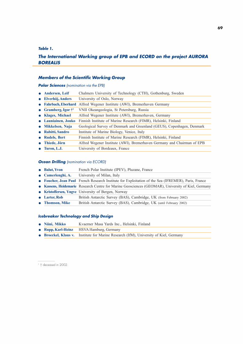
69
Table 1.
The International Working group of EPB and ECORD on the project AURORABOREALIS
Members of the Scientific Working Group
Polar Sciences (nomination via the EPB)
. Andersen, Leif Chalmers University of Technology (CTH), Gothenburg, Sweden
. Elverhöj, Anders University of Oslo, Norway
. Fahrbach, Eberhard Alfred Wegener Institute (AWI), Bremerhaven Germany
. Gramberg, Igor †1 VNII Okeangeologia, St Petersburg, Russia
. Klages, Michael Alfred Wegener Institute (AWI), Bremerhaven, Germany
. Launiainen, Jouko Finnish Institute of Marine Research (FIMR), Helsinki, Finland
. Mikkelsen, Naja Geological Survey of Denmark and Greenland (GEUS), Copenhagen, Denmark
. Rabitti, Sandro Institute of Marine Biology, Venice, Italy
. Rudels, Bert Finnish Institute of Marine Research (FIMR), Helsinki, Finland
. Thiede, Jörn Alfred Wegener Institute (AWI), Bremerhaven Germany and Chairman of EPB
. Turon, L.J. University of Bordeaux, France
Ocean Drilling (nomination via ECORD)
. Balut, Yvon French Polar Institute (IPEV), Pluzane, France
. Camerlenghi, A. University of Milan, Italy
. Foucher, Jean Paul French Research Institute for Exploitation of the Sea (IFREMER), Paris, France
. Kassens, Heidemarie Research Centre for Marine Geosciences (GEOMAR), University of Kiel, Germany
. Kristoffersen, Yngve University of Bergen, Norway
. Larter, Rob British Antarctic Survey (BAS), Cambridge, UK (from February 2002)
. Thomson, Mike British Antarctic Survey (BAS), Cambridge, UK (until February 2002)
Icebreaker Technology and Ship Design
. Niini, Mikko Kvaerner Masa Yards Inc., Helsinki, Finland
. Rupp, Karl-Heinz HSVA Hamburg, Germany
. Broeckel, Klaus v. Institute for Marine Research (IfM), University of Kiel, Germany
1 † deceased in 2002.
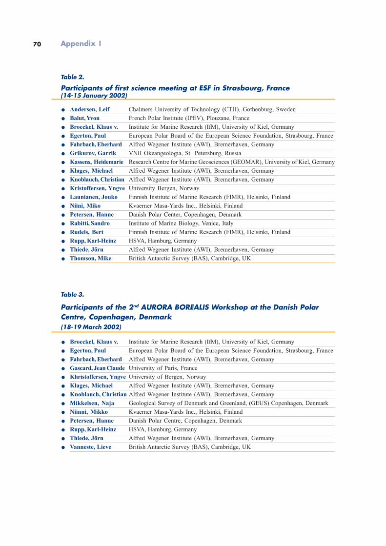
70
Table 2.
Participants of first science meeting at ESF in Strasbourg, France(14-15 January 2002)
. Andersen, Leif Chalmers University of Technology (CTH), Gothenburg, Sweden
. Balut, Yvon French Polar Institute (IPEV), Plouzane, France
. Broeckel, Klaus v. Institute for Marine Research (IfM), University of Kiel, Germany
. Egerton, Paul European Polar Board of the European Science Foundation, Strasbourg, France
. Fahrbach, Eberhard Alfred Wegener Institute (AWI), Bremerhaven, Germany
. Grikurov, Garrik VNII Okeangeologia, St Petersburg, Russia
. Kassens, Heidemarie Research Centre for Marine Geosciences (GEOMAR), University of Kiel, Germany
. Klages, Michael Alfred Wegener Institute (AWI), Bremerhaven, Germany
. Knoblauch, Christian Alfred Wegener Institute (AWI), Bremerhaven, Germany
. Kristoffersen, Yngve University Bergen, Norway
. Launianen, Jouko Finnish Institute of Marine Research (FIMR), Helsinki, Finland
. Niini, Miko Kvaerner Masa-Yards Inc., Helsinki, Finland
. Petersen, Hanne Danish Polar Center, Copenhagen, Denmark
. Rabitti, Sandro Institute of Marine Biology, Venice, Italy
. Rudels, Bert Finnish Institute of Marine Research (FIMR), Helsinki, Finland
. Rupp, Karl-Heinz HSVA, Hamburg, Germany
. Thiede, Jörn Alfred Wegener Institute (AWI), Bremerhaven, Germany
. Thomson, Mike British Antarctic Survey (BAS), Cambridge, UK
Table 3.
Participants of the 2nd AURORA BOREALIS Workshop at the Danish PolarCentre, Copenhagen, Denmark(18-19 March 2002)
. Broeckel, Klaus v. Institute for Marine Research (IfM), University of Kiel, Germany
. Egerton, Paul European Polar Board of the European Science Foundation, Strasbourg, France
. Fahrbach, Eberhard Alfred Wegener Institute (AWI), Bremerhaven, Germany
. Gascard, Jean Claude University of Paris, France
. Khristoffersen, Yngve University of Bergen, Norway
. Klages, Michael Alfred Wegener Institute (AWI), Bremerhaven, Germany
. Knoblauch, Christian Alfred Wegener Institute (AWI), Bremerhaven, Germany
. Mikkelsen, Naja Geological Survey of Denmark and Greenland, (GEUS) Copenhagen, Denmark
. Niinni, Mikko Kvaerner Masa-Yards Inc., Helsinki, Finland
. Petersen, Hanne Danish Polar Centre, Copenhagen, Denmark
. Rupp, Karl-Heinz HSVA, Hamburg, Germany
. Thiede, Jörn Alfred Wegener Institute (AWI), Bremerhaven, Germany
. Vanneste, Lieve British Antarctic Survey (BAS), Cambridge, UK
Appendix I
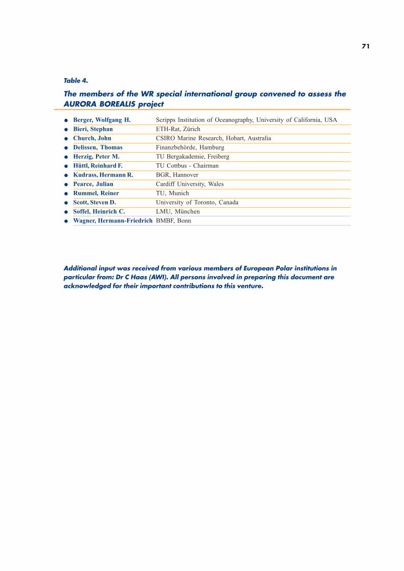
71
Table 4.
The members of the WR special international group convened to assess theAURORA BOREALIS project
. Berger, Wolfgang H. Scripps Institution of Oceanography, University of California, USA
. Bieri, Stephan ETH-Rat, Zürich
. Church, John CSIRO Marine Research, Hobart, Australia
. Delissen, Thomas Finanzbehörde, Hamburg
. Herzig, Peter M. TU Bergakademie, Freiberg
. Hüttl, Reinhard F. TU Cottbus - Chairman
. Kudrass, Hermann R. BGR, Hannover
. Pearce, Julian Cardiff University, Wales
. Rummel, Reiner TU, Munich
. Scott, Steven D. University of Toronto, Canada
. Soffel, Heinrich C. LMU, München
. Wagner, Hermann-Friedrich BMBF, Bonn
Additional input was received from various members of European Polar institutions inparticular from: Dr C Haas (AWI). All persons involved in preparing this document areacknowledged for their important contributions to this venture.
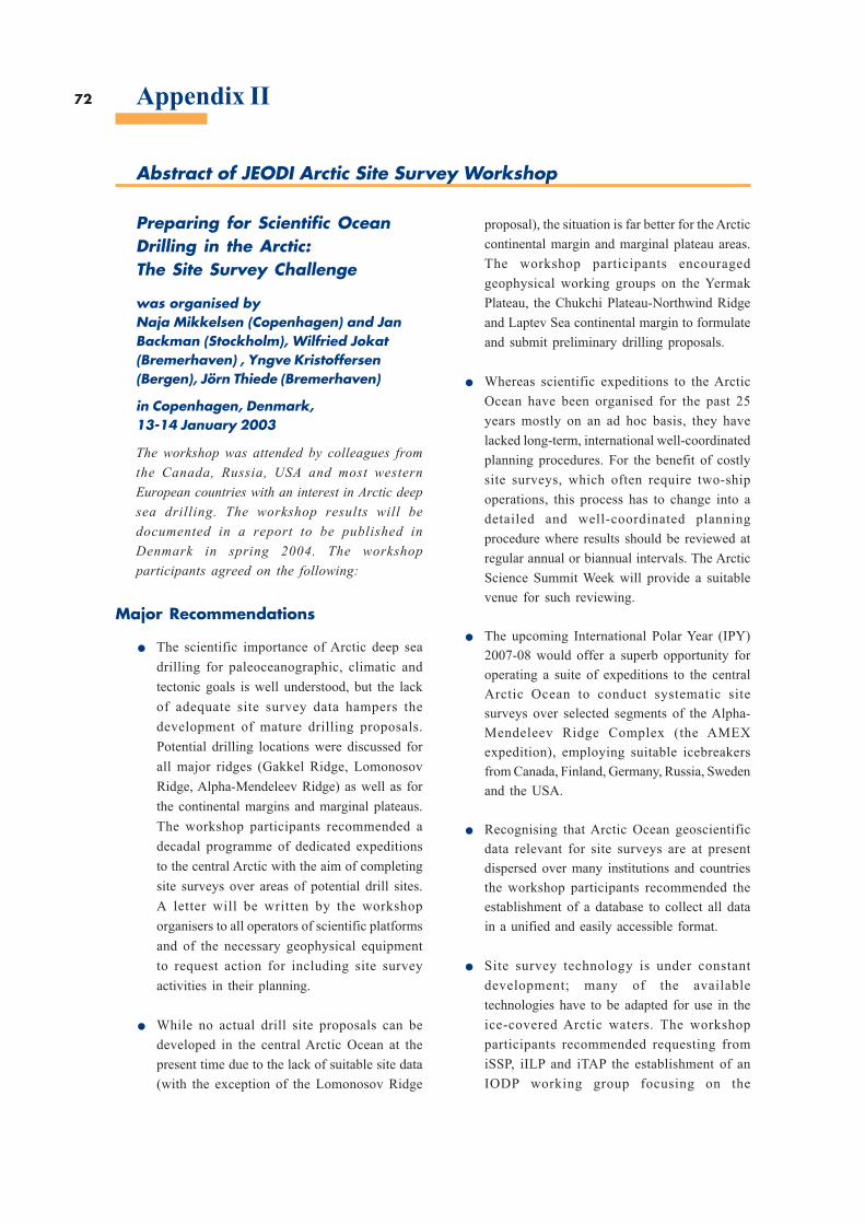
72
Abstract of JEODI Arctic Site Survey Workshop
Appendix II
Preparing for Scientific OceanDrilling in the Arctic:The Site Survey Challenge
was organised byNaja Mikkelsen (Copenhagen) and JanBackman (Stockholm), Wilfried Jokat(Bremerhaven) , Yngve Kristoffersen(Bergen), Jörn Thiede (Bremerhaven)
in Copenhagen, Denmark,13-14 January 2003
The workshop was attended by colleagues from
the Canada, Russia, USA and most western
European countries with an interest in Arctic deep
sea drilling. The workshop results will be
documented in a report to be published in
Denmark in spring 2004. The workshop
participants agreed on the following:
Major Recommendations
. The scientific importance of Arctic deep sea
drilling for paleoceanographic, climatic and
tectonic goals is well understood, but the lack
of adequate site survey data hampers the
development of mature drilling proposals.
Potential drilling locations were discussed for
all major ridges (Gakkel Ridge, Lomonosov
Ridge, Alpha-Mendeleev Ridge) as well as for
the continental margins and marginal plateaus.
The workshop participants recommended a
decadal programme of dedicated expeditions
to the central Arctic with the aim of completing
site surveys over areas of potential drill sites.
A letter will be written by the workshop
organisers to all operators of scientific platforms
and of the necessary geophysical equipment
to request action for including site survey
activities in their planning.
. While no actual drill site proposals can be
developed in the central Arctic Ocean at the
present time due to the lack of suitable site data
(with the exception of the Lomonosov Ridge
proposal), the situation is far better for the Arctic
continental margin and marginal plateau areas.
The workshop participants encouraged
geophysical working groups on the Yermak
Plateau, the Chukchi Plateau-Northwind Ridge
and Laptev Sea continental margin to formulate
and submit preliminary drilling proposals.
. Whereas scientific expeditions to the Arctic
Ocean have been organised for the past 25
years mostly on an ad hoc basis, they have
lacked long-term, international well-coordinated
planning procedures. For the benefit of costly
site surveys, which often require two-ship
operations, this process has to change into a
detailed and well-coordinated planning
procedure where results should be reviewed at
regular annual or biannual intervals. The Arctic
Science Summit Week will provide a suitable
venue for such reviewing.
. The upcoming International Polar Year (IPY)
2007-08 would offer a superb opportunity for
operating a suite of expeditions to the central
Arctic Ocean to conduct systematic site
surveys over selected segments of the Alpha-
Mendeleev Ridge Complex (the AMEX
expedition), employing suitable icebreakers
from Canada, Finland, Germany, Russia, Sweden
and the USA.
. Recognising that Arctic Ocean geoscientific
data relevant for site surveys are at present
dispersed over many institutions and countries
the workshop participants recommended the
establishment of a database to collect all data
in a unified and easily accessible format.
. Site survey technology is under constant
development; many of the available
technologies have to be adapted for use in the
ice-covered Arctic waters. The workshop
participants recommended requesting from
iSSP, iILP and iTAP the establishment of an
IODP working group focusing on the
73
development of site survey strategies for the
Arctic Ocean. This should be brought to the
attention of the three panel chairs soon, in order
to be put on the agenda for the Panel Chairs
meeting in March 2003.
. Drilling technology for ice-covered deep sea
basins has yet to be tested. Proposals for drill
ships capable of operating in the central Arctic
were discussed and the workshop participants
encouraged further development of the plans.
. There is a major need for communication within
the Arctic geoscientific community. The
workshop participants recommended a follow-
up workshop in two years’ time. The
continuation of the communication can be
organised by the existing NAD organisation,
which is an associate programme to ODP and
which maintains a newsletter (The Nansen
Icebreaker).
. The workshop participants recommended
publication of the detailed workshop results in
the Bulletin of the Geological Survey of
Denmark and Greenland.
74 Appendix III
References
Aagaard, K. and E. C. Carmack, 1994: The Arctic Ocean andClimate: A Perspective, - In: O. M. Johannesen, R. D.Muench and J. E. Overland (eds): The Polar Oceans andtheir Role in Shaping the Global Environment.Geophysical Monograph 85, AGU, Washington D.C.,5-20.
Aagaard, K., J. H. Swift, and E. C. Carmack, 1985:Thermohaline circulation in the Arctic Mediterraneanseas, Journal of Geophysical Research, 90, 4833-4846.
Anderson, L.G., 2002: DOC in the Arctic Ocean, - In: D. A.Hansel and C. A. Carlson (eds): Biogeochemistry ofMarine Dissolved Organic Matter, Academic Press, 665-683.
Anderson, L. G. and Kaltin, S., 2001: Carbon fluxes in theArctic Ocean – potential impact by climate change. Polar
Research, 20(2), 225-232.
Anderson, L.G., E.P. Jones, and B. Rudels, 1999: Ventilationof the Arctic Ocean estimated by a plume entrainmentmodel constrained by CFCs, Journal of Geophysical
Research, 104, 13423-13429.
Anderson, L.G., M. Chierici, E. Fogelqvist, and T.Johannessen, Flux of Anthropogenic and Steady Statecarbon into the deep Greenland Sea. Journal of
Geophysical Research, 105(14), 339-14,345, 2000.
Anderson, L.G., M. Chierici, A. Fransson, K. Olsson, andE.P. Jones, Anthropogenic carbon dioxide in the ArcticOcean: Inventory and sinks. Journal of Geophysical
Research, 103(27), 707-27,716, 1998.
Andreassen, I., Nöthig, E. M. & Wassmann, P., 1996: Verticalparticle flux on the shelf off northern Spitsbergen. Marine
Ecology Progress Series, 137, 215-218.
Bauch, D., Erlenkeuser, H., Stanovoy, V., Simstich, J.,Spielhagen, R.F., 2003: Freshwater distribution and brinewaters in the southern Kara Sea in summer 1999, - In: R.Stein, K. Fahl, D.K. Fütterer, and E. Galimov (eds),Proceedings in marine science: Siberian river run-off inthe Kara Sea: characterisation, quantification, variabilityand environmantal significance, Elsevier, Amsterdam, 73-90.
Carmack, E. C., 2000: The Arctic Ocean’s freshwater budget.Sources, storage and export, - In: E. L. Lewis, E. P.Jones, P. Lemke, T. D. Prowse, P. Wadhams (eds): TheFreshwater Budget of the Arctic Ocean, Kluwer AcademicPublisher, Dordrecht, 91-126.
Carmack, E. C., R. W. Macdonald, R. G. Perkin, F. A.McLaughlin, and R. J. Pearson, 1995: Evidence forwarming of Atlantic Water in the Southern CanadianBasin of the Arctic Ocean: Results from the Larsen-93Expeditions, Geophysical Research Letters, 22(9), 1061-1064.
Cavalieri, D. J. and S. Martin, 1994: The contribution ofAlaskan, Siberian, and Canadian coastal polynias to thecold halocline layer of the Arctic Ocean, Journal of
Geophysical Research, 99(C9), 18343-18362.
Codispoti, L.A., Friederich, G.E., Sakamoto, C.M. & Gordon,L.I., 1991: Nutrient cycling and primary production inthe marine systems of the Arctic and Antarctic. Journal
of Marine Systems, 2(3-4), 359-384.
Comiso, J.C., 2002: A rapidly declining perennial sea icecover in the Arctic. Geophysical Research Letters,
29(20), 1956, doi:10.1029/2002GL015650.
Comiso, J. C., 2003: Warming Trends in the Arctic fromClear Sky Satellite Observations, Journal of Climate,
16(21), 3498-3510.
Curry, J.A., J.L. Schramm, D. Perovich, and J.O. Pinto ,2001: Application of SHEBA/FIRE data to evaluationof sea ice surface albedo parameterizations. Journal of
Geophysical Research, 106(D14), 15345-15355.
Dickson, B., J. Hurrell, N. Bindoff, A. Wong, B. Arbic, B.Owens, S. Imawaki and I. Yashayaev, 2001: The Worldduring WOCE, - In: G. Siedler, J. Church and J. Gould(eds.): Ocean Circulation and Climate, Academic Press,San Diego, 557-584.
Dickson, R. R., T. J. Osborn, J. W. Hurrell, J. Meincke, J.Blindheim, B. Adlandsvik, T. Vinje, G. Alekseev and W.Maslowski, 2000: The Arctic Ocean Response to theNorth Atlantic Oscillation, Journal of Climate, 13(15),
2671-2696.
Drucker, R. and S. Martin, 2003: Observations of icethickness and frazil ice in the St Lawrence Island polyniafrom satellite imagery, upward looking sonar, and salinity/temperature moorings, Journal of Geophysical Research,108(C5), 3149, doi:10.1029/2001JC001213.
Dukhovskoy, D. S., M. A. Johnson, Proshutinsky, A., 2004:Arctic decadal variability: An auto-oscillatory systemof heat and freshwater exchange, Geophysical Research
Letters, 31, L03302, doi: 10.1029/2003GL019023.
Edmonds, H.N. et al. (2003): Nature, 421: 252-256.
Eicken, H. and P. Lemke, 2001: The response of polar seaice to climate variability and change, - In: J. L. Lozan, H.Grassl and P. Hupfer (eds): Climate of the 21st Century:Changes and Risks; Wissenschaftliche Auswertungen,Hamburg.
Fahrbach, E., J. Meincke, S. Osterhus, G. Rohardt, U.Schauer, V. Tverberg and J. Verduin, (2001): Directmeasurements of volume transports through Fram Strait,Polar Research, 20(2), 217-224.
Fer, I., R. Skogseth, P. M. Haugan and P. Jaccard, 2003:Observations of the Storfjorden overflow, Deep Sea
Research I(50), 1283-1303.
Gerdes, R., Karcher, M., Kauker, F., Schauer, U., 2003:Causes and development of repeated Arctic Oceanwarming events, Geophysical Research Letters, 30(19),
1980. DOI: 10.1029/2003GL018080.
Gloersen, P., W.J. Campbell, D.J. Cavalieri, J.C. Comiso,C.L. Parkinson, and H.J. Zwally, 1992: Arctic andAntarctic sea ice, 1978-1987: satellite passive-microwave observations and analysis. NASA SP-511,National Aeronautics and Space Administration,Washington, DC.
Gordeev V. V., Martin J.M., Sidorov I.S., Sidorova M.V.,1996: A reassessment of the Eurasian River input ofwater, sediment, major elements, and nutrients to theArctic Ocean, American Journal of Science, 296, 664-691.
75
Haarpainter, J., J.-C. Gascard, P. M. Haugan, 2001: Iceproduction and brine formation in Storfjorden, Svalbard,Journal of Geophysical Research, 106(C7), 14,001-14,013.
Haas, C., 2002: Validation of CryoSat Sea ice Products:Instruments and Methods, Proceedings, InternationalGeoscience and Remote Sensing Symposium 2002,IGARSS02, Toronto, Canada, 1753-1755.
Hansen, B., Christiansen, S. and Pedersen, G., 1995: Planktondynamics in the marginal ice zone of the central BarentsSea during spring: carbon flow and structure of the grazerfood chain. Polar Biology, 16, 115-128.
Harms, I. H., Hübner, U., Backhaus, J. O., Kulakov, M.,Stanovoy, V., Stepanets, O., Kodina, L., Schlitzer, R.,2003: Salt intrusions in Siberian River Estuaries -Observations and model experiments in Ob and Yenisei,- In: R. Stein, K. Fahl, D.K. Fütterer, and E. Galimov(eds) Proceedings in marine science: Siberian river run-off in the Kara Sea: characterisation, quantification,variability and environmental significance, Elsevier,Amsterdam, 27-46.
Harris, N.R.P., I. Kilbane-Dawe and G. T. Amanatidis (eds):Polar stratospheric ozone 1997, Air pollution researchreport 66, European Communities 1998; 772 pages,ISBN 92-828-2365-2.
Holloway, G., and T. Sou, 2002: Has Arctic sea ice rapidlythinned? Journal of Climate, 15, 1691-1701.
Horner, R., 1990: Ice-associated ecosystems, - In: L. Medlin,Priddle, J. (eds): Polar marine diatoms, British AntarcticSurvey, Cambridge, 9-14.
Houghton, J.T., Y. Ding, D. J. Griggs, M. Noguer, P.J. vander Linden and X. Dai, K. Maskell and C. A. Johnson(eds), 2001: Climate Change 2001, The scientific Basis.Cambridge: Cambridge University Press.
Hulth, S., Hall, P. O. J., Blackburn, T. H. and Landen, A.,1996: Arctic sediments (Svalbard): pore water and solidphase distribution of C, N, P and Si. Polar Biology, 16,447-462.
Hurrell, J. W., 1995: Decadal trends in the North Atlanticoscillation: Regional temperatures and precipitation.Science, 269, 676-679.
Ingvaldsen, R., H. Loeng and L. Asplin, 2002: Variability inthe Atlantic inflow to the Barents Sea based on a one-year time series from moored current meters, Continental
Shelf Research, 22, 505-519.
Jacobsson, M., Cherkis, N.Z., Woodward, J., Macnab, R.and Coakley, B. (2000): New grid of Arctic bathymetryaids scientists and mapmakers, EOS, 81 (9): 89-96.
Jakobsson, M., Grantz, A., Kristoffersen, Y. and Macnab,R., (2002): Physiographic provinces of the Arctic Oceanseafloor. GSA Bulletin, 115 (11), 12 pp.
Jokat, W., Ritzmann, O., Schmidt-Aursch, M.C., Drachev,S., Gauger, S. and Snow, J. (2003): Geophysical evidencefor reduced melt production of the Arctic ultrashowGakkel mid-ocean ridge. Nature, 423: 962-965.
Jones, E. P., L. G. Anderson, J. H. Swift, 1998: Distributionof Atlantic and Pacific waters in the upper Arctic Ocean:Implications for circulation, Geophysical Research
Letters, 25(6), 765-768.
Karcher, M. J., R. Gerdes, F. Kauker, C. Koeberle, 2003:Arctic warming - Evolution and Spreading of the 1990swarm event in the Nordic Seas and the Arctic Ocean,Journal of Geophysical Research, 108(C2), 3034,doi:10.1029/2001JC001265.
Kassens, H., Bauch, H.A., Dmitrenko, I.A., Eicken, H.,Hubberten, H.-W., Melles, M., Thiede, J. and Timokhov,L. (Eds), (2002): Land-Ocean Systems in the SiberianArctic, Springer-Verlag, Berlin-Heidelberg-New York,711 pp.
Klages, M. et al. (in prep.): Cruise Report ARKXIX/3.Berichte zur Polar- und Meeresforschung.
Kristoffersen, Y., Husebye, E.S., Bungum, H. and Gregersen,S. (1982): Seismic investigations of the Nansen Ridgeduring the FRAM I experiment, Tectonophysics, 82: 57-68.
Launiainen J. and T. Vihma, 1994: On the surface fluxes inthe Weddell Sea, - In: O. M. Johannesen, R. D. Muenchand J. E. Overland (eds): The Polar Oceans and theirRole in Shaping the Global Environment. GeophysicalMonograph 85, AGU. Washington D.C., 399-419.
Laxon, S.W., 1994: Sea ice altimeter processing scheme atthe EODC, International Journal of Remote Sensing,15(4), 915-924.
Lemke, P., 2001: Polynias - Open windows to the polaroceans. Science, 292: 1670-1671.
Luchetta, A., Lipizer, M. & Socal, G., 2000: Temporalevolution of primary production in the Central BarentsSea. Journal of Marine Systems, 27, 177-193.
Maslowski W., B. Newton, P. Schlosser, A. Semtner,Martinson, D., 2000: Modeling Recent ClimateVariability in the Arctic Ocean. Geophysical Research
Letters, 27(22), 3743-3746.
Maykut and Untersteiner, Some results from a timedependent thermodynamic model of sea ice, Journal of
Geophysical Research, 76(6), 1550-1575, 1971.
McCarthy, J. J., O. F. Canziani, N. A. Leary, D. J. Dokken,K. S. White, (eds), 2001: Climate Change 2001: Impacts,Adaptation, and Vulnerability. Cambridge, CambridgeUniversity Press.
McLaughlin, F., E. Carmack, R. MacDonald, A. J. Weaverand J. Smith, 2002: The Canada Basin, 1989-1995:Upstream events and far-field effects of the BarentsSea, Journal of Geophysical Research, 107(C7), 10.1029/2001JC000904.
McLaughlin F. A., E. C. Carmack, R. W. MacDonald and J.K. B. Bishop, 1996: Physical and geochemical propertiesacross the Atlantic/Pacific water mass front in thesouthern Canadian Basin, Journal of Geophysical
Research, 101(C1), 1183-1197.
Michael, P.J., Langmuir, C.H., Dick, H.J.B., Snow, J.E.,Goldstein, S.L., Graham, D.W., Lehnert, K., Kurras, G.,Jokat, W., Mühe, R. and Edmonds, H.N. (2003):Magmatic and amagmatic seafloor generation at theultraslow-spreading Gakkel ridge, Arctic Ocean. Nature,423: 956-961.
Midttun, L., 1985: Formation of dense bottom water in theBarents Sea, Deep Sea Research A, 32, 1233-1241.
76 Appendix III
Morison J., M. Steele and R. Andersen, 1998: Hydrographyof the upper Arctic Ocean measured from the nuclearsubmarine U.S.S. Pargo, Deep Sea Res., 45(1), 15-38.
Nürnberg, D., Wollenburg, I., Dethleff, D., Eicken, H.,Kassens, H., Letzig, T., Reimnitz, E. and Thiede, J.(1994): Sediments in Arctic sea ice – entrainment,transport and release. Mar. Geol., 119: 185-214.
Owrid, G. Socal, G. Civitarese, G. Luchetta, A. Wiktor, J.Nöthig, E.M. Andreassen, I. Schauer, U. Strass, V., 2000.Spatial variability of phytoplankton, nutrients and newproduction estimates in the waters around Svalbard(Summer 1991). Polar Research, 19(2): 155-171.
Parkes, R.J., Cragg, B.A., Bale, S.J., Getliff, J.M., Goodman,K., Rochelle, P.A., Fry, J.C., Weightman, A.J. and Harvey,S.M. (1994): Deep bacterial biosphere in Pacific Oceansediments. Nature, 371: 410-413.
Pease, C. H., 1987: The Size of Wind-Driven CoastalPolynias, Journal of Geophysical Research, 92(C7),7049-7059.
Pesant, S., Legendre, L., Grosselin, M., Smith, R.E.H.,Kattner, G. and Ramseier, R.O., 1996: Size-differentialregimes of phytoplankton production in the NortheastWater Polynia (77°-81°N). Marine Ecology Progress
Series, 142, 75-86.
Pfirman, S., Lange, M.A., Wollenburg, I and Schlosser, P.(1990): Sea ice characteristics and the role of sedimentinclusions in deep sea deposition. In: Artic and Antarcticcomparisons. U.Bleil and Thiede, J. (Eds.) GeologicalHistory of the Polar Oceans: Arctic versus Antarctic.Kluwer Academic Publishers: 187-211.
Proshutinsky, A. Y. and M. A. Johnson, 1997: Twocirculation regimes of the wind-driven Arctic Ocean,Journal of Geophysical Research, 102(C6), 12493-12514.
Proshutinsky, A., R. H. Bourke, F. A. McLaughlin, 2002:The role of the Beaufort Gyre in Arctic climatevariability: Seasonal to decadal climate scales,Geophysical Research Letters, 29(23), doi:10.1029/2002GL015847.
Przybylak, R., 2003 : The Climate of the Arctic. Atmosphericand Oceanographic Sciences Library, 26, KluwerAcademic Publisher, Dordrecht, 270 pages.
Rey, F. & Loeng, H., 1985: The influence of ice andhydrography conditions on the development ofphytoplankton in the Barents Sea, - In: J. S. Gray andM. E. Christiansen, (eds): Marine biology of polar regionsand effects of stress on marine organisms. John Wiley &Sons Ltd, London 49-63.
Roach, A.T., K. Aagaard, C. H. Pease, S.A. Salo, T.Weingartner, V. Pavlov, and M. Kulakov, 1995: Directmeasurements of transport and water properties throughBering Strait, Journal of Geophysical Research, 100(18),
443-18,457.
Romanovskii, N.N., Hubberten, H.-W., Gavrilov, A.V.,Tumskoy, V.E. and Kholodov, A.L. (Article In Press,Corrected Proof): Permafrost of the East Siberian ArcticShelf and Coastal Lowlands. Quaternary ScienceReviews: QUEEN Synthesis Volume (In Press).
Rothrock, D.A., Y. Yu, and G. A. Maykut, 1999: Thinningof the Arctic Sea ice Cover. Geophysical Research Letters,
26, 3469-3472.
Rothrock, D. A., J. Zhang and Y. Yu, 2003: The arctic icethickness anomaly of the 1990s: A consistent view fromobservations and models, Journal of Geophysical
Research, 108(C3), 3083, doi: 10.1029/2001JC001208.
Rudels, B., 1994: The thermohaline circulation of the ArcticOcean and the Greenland Sea, Phil. Trans, R. Soc. Lond.,A, 352, 287-299.
Rudels, B. 2001: Arctic Basin Circulation, - In: J.M. Steele,S.A. Thorpe and K.K. Turekian (eds): Encyclopedia ofOcean Sciences, Academic Press, London, 177-187.
Rudels, B. and Friedrich, H. J., 2000: The transformationsof Atlantic water in the Arctic Ocean and their significancefor the freshwater budget, - In: E. L. Lewis, E. P. Jones,P. Lemke, T. D. Prowse, P. Wadhams, (eds): TheFreshwater Budget of the Arctic Ocean, Kluwer AcademicPublisher, Dordrecht 91-126.
Rudels, B., L.G. Anderson, and E.P. Jones, 1996: Formationand evolution of the surface mixed layer and the haloclineof the Arctic Ocean, Journal of Geophysical Research,101, 8807-8821.
Rudels, B., H. J. Friedrich and D. Quadfasel, 1999a: TheArctic Circumpolar Boundary Current, Deep Sea
Research II, 46, 1023-1062.
Rudels, B., H. J. Friedrich, D. Hainbucher and G. Lohmann,1999b: On the parameterisation of oceanic sensible heatloss to the atmospheric and to ice in an ice-covered mixedlayer in winter, Deep Sea Research II, 46, 1385-1425.
Rudels, B., E. P. Jones, L. G. Anderson and G. Kattner,1994: On the Intermediate Depth Waters of the ArcticOcean, - In: O. M. Johannesen, R. D. Muench and J. E.Overland, (eds): The Polar Oceans and their Role inShaping the Global Environment. GeophysicalMonograph 85, AGU. Washington D.C, 33-46.
Rudels B., R. Meyer, E. Fahrbach, V. V. Ivanov, S. Østerhus,D. Quadfasel, U. Schauer, V. Tverberg, R. A. Woodgate,2000: Water mass distribution in Fram Strait and overthe Yermak Plateau in summer 1997, Annales.
Geophysicae, 18, 687-705.
Sakshaug, E., 1990: Arctic planktonic ecosystem, - In:Medlin, L., Priddle, J. (eds): Polar marine diatoms,British Antarctic Survey, Cambridge, 47-51.
Savinov, V.M., 1992: Spatial distribution of chlorophyll andprimary production, - In: (ed.) Phytoplankton in theBarents Sea. Apatity: Murmansk Marine BiologicalInstitute. Russian Academy of Science, 52-53.
Schauer, U. and E. Fahrbach, (1999): A dense bottom waterplume in the western Barents Sea: Downstreammodification and interannual variability, Deep sea
Research I, 46, 2095-2108.
Schauer, U., H. Loeng, B. Rudels, V. Ozhigin, and W. Dieck,2002a: Atlantic Water flow through the Barents and KaraSeas, Deep sea Research I, 49(12), 2281-2298.
Schauer, U., B. Rudels, E.P. Jones, L.G. Anderson, R.D.Muench, G. Björk, J.H. Swift, V. Ivanov, and A.M.Larsson, 2002b: Confluence and redistribution of Atlantic
77
water in the Nansen, Amundsen and Makarov basins,Annales Geophysicae, 20(2), 257-273.
Seereze, M. C., J. E. Walsh, F. S. Chapin III, T. Osterkamp,M. Dyurgerov, V. Romansovsky, 2000: Observationalevidence of recent change in the northern high latitudeenvironment, Climate Change, 46, 159-207.
Seidov, D., B. J. Haupt and M. Maslin (eds.), 2001: Theoceans and rapid climate change: past, present, and future,Geophysical Monograph Series, 126, AGU WashingtonD.C., 293 pages.
Smethie, W.M.Jr., P. Schlosser, G. Bönisch, and T.S. Hopkins(2000), Renewal and circulation of intermediate watersin the Canadian Basin observed on the SCICEX 96 cruise,Journal of Geophysical Research, 105(C1), 1105(1999JC900233) .
Smith, J.N., K.M. Ellis, and T. Boyd (1999), Circulationfeatures in the central Arctic Ocean revealed by nuclearfuel reprocessing tracers from Scientific Ice Expeditions1995 and 1996, Journal of Geophysical Research,104(C12), 29663-29677.
Smith, S. D., R. D. Muench and C. H. Pease, 1990: Polyniasand Leads: An Overview of Physical Processes andEnvironment, Journal of Geophysical Research, 95(C6),
9461-9479.
Snow, J.E., Bock, M., Feldmann, H. (1992): Evidence forHydrothermal Activity, Gakkel Ridge in: Thiede, J. andthe Shipboard Scientific Party, (2002): POLARSTERNARKTIS XVII/2 Cruise Report: AMORE 2001, Berichte
zur Polar und Meeresforschung, 421, 397 pp.
Snow, J.E., Hellebrand, E., Jokat, W. and Mühe, R. (2001):Magmatic and Hydrothermal Activity in Lena Trough,Arctic Ocean. EOS, 82(17): 193-198.
Steele, M., and T. Boyd, 1998: Retreat of the cold haloclinelayer in the Arctic Ocean. Journal of Geophysical
Research, 103, 10419-10435.
Stein, R., Fahl, K., Fütterer, D.K., Galimov, E. M., andStepanets, O. (Eds.), (2003): Siberian River Run-off inthe Kara Sea: Characterisation, Quantification,Variability, and Environmental Significance, Proceedingsin Marine Sciences, 6, Elsevier, Amsterdam, 484 pp.
Strass, V. & Nöthig, E. M., 1996: Seasonal shifts in ice edgephytoplankton blooms in the Barents Sea related to thewater column stability. Polar Biology 16, 409-422.
Strömberg, J.O., 1989: Northern Svalbard waters, - In: L.Rey, V. Alexander, (eds): Proceedings of the 6thConference of the Comité Arctique International. 13-15May 1985, E.J. Brill, Leiden, 402-426.
Swift, J. H., E. P. Jones, K. Aagaard, E. C. Carmack, M.Hingston, R. W. MacDonald et al., 1997: Waters of theMakarov and Canada basins, Deep sea Res. II, 44, 1503-1529.
Syvertsen, E. E., 1991: Ice algae in the Barents Sea: types ofassemblages, origin and role in the ice edge phytoplanktonbloom, - In: E. Sakshaug, C. C. E. Hopkins and N. A.Øristland, (eds): Proceeding from the Pro MareSymposium on Polar Marine Ecology, Trondheim, 12-16 May 1990. Polar Research 10, 277-287.
Thiede, J. and NAD Science Committee, (1992): The ArcticOcean Record: Key to Global Change (Initial SciencePlan). Polarforschung, 61/1: 102 pp.
Thiede, J. and the Shipboard Scientific Party, 2002: Polarstern
Arktis XVII/2 Cruise Report: AMORE 2001, Berichte
zur Polar und Meeresforschung, 421, 397 pages
Thompson, D. W. J. and J. M. Wallace, 1998: The ArcticOscillation signature in the wintertime geopotential heightand temperature fields, Geophysical Research Letters,
25, 1297-1300.
Thompson, D. W. J. and J. M. Wallace, 2000a: Angularmodes in the extratropical circulation. Part I: Month tomonth variability, Journal of Climate, 13, 1000-1016.
Thompson, D. W. J., J. M. Wallace and G. C. Hiegerl, 2000b:Annular modes in the extratropical circulation. Part II:Trends, Journal of Climate, 13, 1018-1036.
Vinje, T., N. Nordlund, and A. Kvambekk, 1998: Monitoringice thickness in Fram Strait. Journal of Geophysical
Research, 103, 10437-10450.
Vinnikov, K.Y., A. Robock, R.J. Stouffer, J.E. Walsh, C.L.Parkinson, D.J. Cavalieri, J.F.B. Mitchell, D. Garrett,and V.F. Zakharov, 1999: Global warming and NorthernHemisphere sea ice extent. Science, 286, 1934-1937.
Vörösmarty, C.J., Hinzman, L.D., Peterson, B.J., Bromwich,D.H., Hamilton, L.C., Morison, J. Romanovsky, V.E.,Sturm, M. and Webb, R.S., 2001: The Hydrologic Cycleand its Role in Arctic and Global Environmental Change:A Rationale and Strategy for Synthesis Study. Fairbanks,Alaska: Arctic Research Consortium of the U.S., 84 pages.
Wadhams, P. 2000: Ice in the ocean, Gordon and BreachScience Publishers, Amsterdam, 351 pages.
Wadhams, P., and N.R. Davis, 2000: Further evidence ofthinning in the Arctic Ocean. Geophysical Research
Letters, 27, 3973-3975.
Weber, J.R. and Sweeney, J.F. (1990): Ridges and basins inthe central Arctic Ocean. In: Grantz, A., Johnson, G.L.,and Sweeney, J.F. (eds.), The Arctic Ocean Region: TheGeology of North America DNAG L: 305-336.
Winsor, P. and G. Björk, 2000: Polynia activity in the ArcticOcean from 1958 to 1997, Journal of Geophysical
Research, 105(C4), 8789-8803.
Woodgate, R. A., K. Aagaard, R. D. Muench, J. Gunn, G.Björk, B. Rudels, A. T. Roach and U. Schauer, 2001:The Arctic Boundary Current along the Eurasian slopeand the adjacent Lomonosov Ridge: Water massproperties, transports and transformations from mooredinstruments, Deep Sea Research, 48(8), 1757-1792.
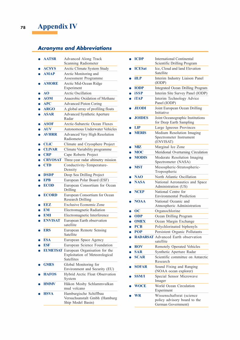
78 Appendix IV
Acronyms and Abbreviations
. AATSR Advanced Along TrackScanning Radiometer. ACSYS Arctic Climate System Study. AMAP Arctic Monitoring andAssessment Programme. AMORE Arctic Mid-Ocean RidgeExperiment. AO Arctic Oscillation. AOM Anaerobic Oxidation of Methane. APC Advanced Piston Coring. ARGO A global array of profiling floats. ASAR Advanced Synthetic ApertureRadar. ASOF Arctic-Subarctic Ocean Fluxes. AUV Autonomous Underwater Vehicles. AVHRR Advanced Very High ResolutionRadiometer. CLiC Climate and Cryosphere Project. CLIVAR Climate Variability programme. CRP Cape Roberts Project. CRYOSAT Three-year radar altimetry mission. CTD Conductivity-Temperature-Density. DSDP Deep Sea Drilling Project. EPB European Polar Board (ESF). ECOD European Consortium for OceanDrilling. ECORD European Consortium for OceanResearch Drilling. EEZ Exclusive Economic Zone. EM Electromagnetic Radiation. EMI Electromagnetic Interference. ENVISAT European Earth observationsatellite. ERS European Remote SensingSatellite. ESA European Space Agency. ESF European Science Foundation. EUMETSAT European Organisation for theExploitation of MeteorologicalSatellites. GMES Global Monitoring forEnvironment and Security (EU). HAFOS Hybrid Arctic Float ObservationSystem. HMMV Håkon Mosby Schlammvulkanmud volcano. HSVA Hamburgische SchiffbauVersuchsanstalt Gmbh (HamburgShip Model Basin)
. ICDP International ContinentalScientific Drilling Program. ICESat Ice, Cloud and land ElevationSatellite. iILP Interim Industry Liaison Panel(IODP). IODP Integrated Ocean Drilling Program. iSSP Interim Site Survey Panel (IODP). iTAP Interim Technology AdvicePanel (IODP). JEODI Joint European Ocean DrillingInitiative. JOIDES Joint Oceanographic Institutionsfor Deep Earth Sampling. LIP Large Igneous Provinces. MERIS Medium Resolution ImagingSpectrometer Instrument(ENVISAT). MIZ Marginal Ice Zone. MOC Meridional Overturning Circulation. MODIS Moderate Resolution ImagingSpectrometer (NASA). MST Mesospheric-Stratospheric-Tropospheric. NAO North Atlantic Oscillation. NASA National Aeronautics and SpaceAdministration (US). NCEP National Centre forEnvironmental Prediction. NOAA National Oceanic andAtmospheric Administration. OC Organochlorine. ODP Ocean Drilling Program. OMEX Ocean Margin Exchange. PCB Polychlorinated biphenyls. POP Persistent Organic Pollutants. RADARSAT Advanced Earth observationsatellite. ROV Remotely Operated Vehicles. SAR Synthetic Aperture Radar. SCAR Scientific committee on AntarcticResearch. SOFAR Sound Fixing and Ranging(NOAA ocean explorer). SSM/I Special Sensor MicrowaveImager. WOCE World Ocean CirculationExperiment. WR Wissenschaftsrat (sciencepolicy advisory board to theGerman Government)
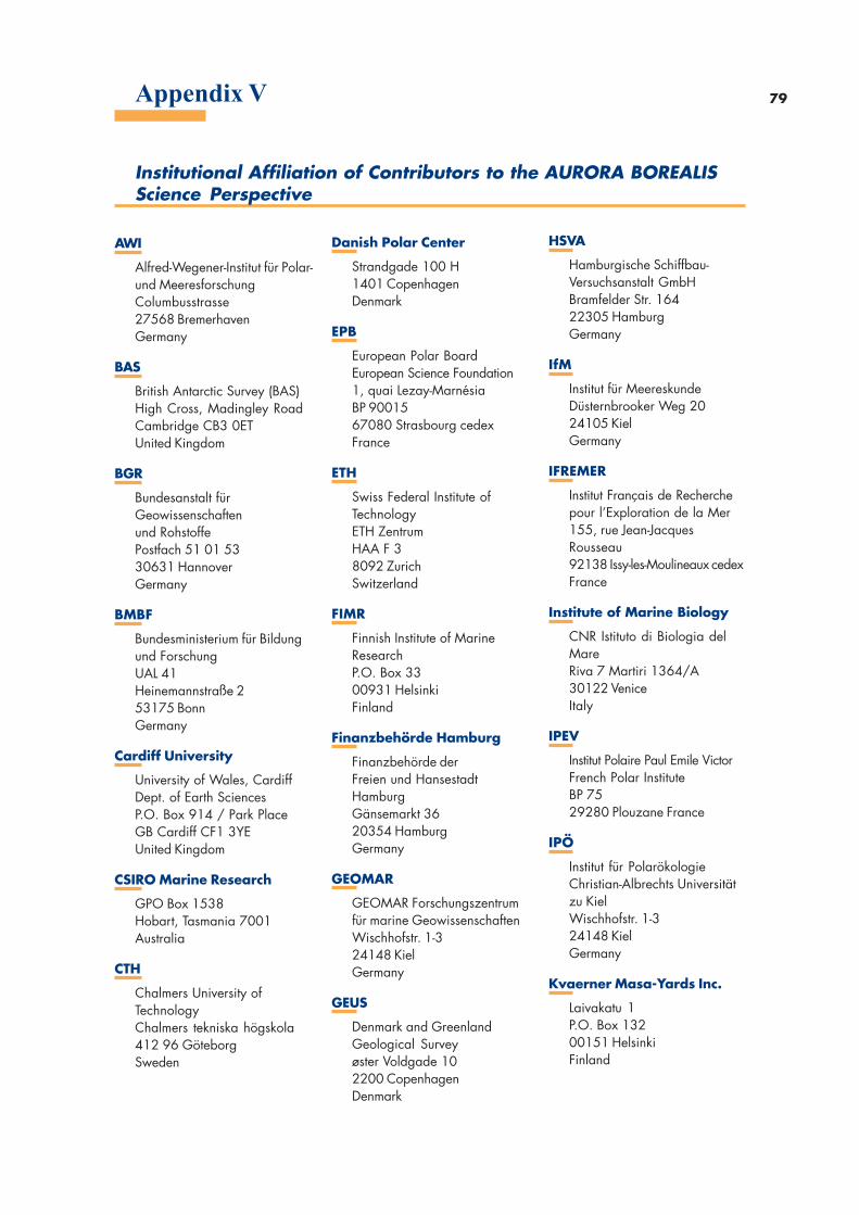
79Appendix V
AWI
Alfred-Wegener-Institut für Polar-und MeeresforschungColumbusstrasse27568 BremerhavenGermany
BAS
British Antarctic Survey (BAS)High Cross, Madingley RoadCambridge CB3 0ETUnited Kingdom
BGR
Bundesanstalt fürGeowissenschaftenund RohstoffePostfach 51 01 5330631 HannoverGermany
BMBF
Bundesministerium für Bildungund ForschungUAL 41Heinemannstraße 253175 BonnGermany
Cardiff University
University of Wales, CardiffDept. of Earth SciencesP.O. Box 914 / Park PlaceGB Cardiff CF1 3YEUnited Kingdom
CSIRO Marine Research
GPO Box 1538Hobart, Tasmania 7001Australia
CTH
Chalmers University ofTechnologyChalmers tekniska högskola412 96 GöteborgSweden
Danish Polar Center
Strandgade 100 H1401 CopenhagenDenmark
EPB
European Polar BoardEuropean Science Foundation1, quai Lezay-MarnésiaBP 9001567080 Strasbourg cedexFrance
ETH
Swiss Federal Institute ofTechnologyETH ZentrumHAA F 38092 ZurichSwitzerland
FIMR
Finnish Institute of MarineResearchP.O. Box 3300931 HelsinkiFinland
Finanzbehörde Hamburg
Finanzbehörde derFreien und HansestadtHamburgGänsemarkt 3620354 HamburgGermany
GEOMAR
GEOMAR Forschungszentrumfür marine GeowissenschaftenWischhofstr. 1-324148 KielGermany
GEUS
Denmark and GreenlandGeological Surveyøster Voldgade 102200 CopenhagenDenmark
HSVA
Hamburgische Schiffbau-Versuchsanstalt GmbHBramfelder Str. 16422305 HamburgGermany
IfM
Institut für MeereskundeDüsternbrooker Weg 2024105 KielGermany
IFREMER
Institut Français de Recherchepour l’Exploration de la Mer155, rue Jean-JacquesRousseau92138 Issy-les-Moulineaux cedexFrance
Institute of Marine Biology
CNR Istituto di Biologia delMareRiva 7 Martiri 1364/A30122 VeniceItaly
IPEV
Institut Polaire Paul Emile VictorFrench Polar InstituteBP 7529280 Plouzane France
IPÖ
Institut für PolarökologieChristian-Albrechts Universitätzu KielWischhofstr. 1-324148 KielGermany
Kvaerner Masa-Yards Inc.
Laivakatu 1P.O. Box 13200151 HelsinkiFinland
Institutional Affiliation of Contributors to the AURORA BOREALISScience Perspective
80
LMU
Universität MünchenInstitut für Allgemeine undAngewandte GeophysikTheresienstraße 4180333 MünchenGermany
Scripps Institution ofOceanography
University of CaliforniaSan Diego - 05249500 Gilman DriveLa Jolla, CA 92093USA
TU Bergakademie
Bergakademie FreibergInstitut für MineralogieBrennhausgasse 1409596 FreibergGermany
TU Cottbus
Technische Universität CottbusPostfach 10 13 4403013 CottbusGermany
TU München
Institut für Astronomische undPhysikalische Geodäsie der TUArcisstrasse 2180333 MünchenGermany
University of Toronto
Geological DepartmentNigel Edwards Departmentof GeophysicsToronto M6H 2X0Canada
University of Bergen
Universitetet i BergenJordskjelvstasjonenAllegate 415000 BergenNorway
University of Bordeaux
Université de Bordeaux 1 DGOAvenue des Facultés33405 Talence cedexFrance
University of Milan
Università di MilanoDipartimento Scienzedella TerraVia Mangiagalli, 3420133 MilanoItaly
University of Oslo
University of OsloDepartment of GeologyBox 1047 Blindern0316 Oslo 33Norway
University of Paris
L.O.D.Y.C. Université Paris 6Lab. d’OcéanographieDynamique et de Climatologie4 Place Jussieu75252 Paris cedex 05France
VNII Okeanogeologia
All-Russian Research Institutefor Geology andMineral Resources of theWorld OceanAngliskiy Pr., 1190121 St. PetersburgRussia
Appendix V
Imp
ress
ion
IR
EG
Str
asb
ou
r g -
Dép
ôt
légal
: ju
ille
t 2004 -
N°
d’o
rdre
04
24
78