€¦ · web viewbamako, mali. boubacar amadou diallo1, bao zhengyu2. 1department of geography,...
TRANSCRIPT
Researcher 2010;2(4)
Land Cover Change Assessment Using Remote Sensing: Case Study ofBamako, Mali
Boubacar Amadou DIALLO1, BAO Zhengyu2
1Department of Geography, China University of Geosciences, Wuhan, ChinaBP 430074, Lumo Road 388
2Key Laboratory of Biogeology and Environmental Geology of Ministry of Education, China University of Geosciences Wuhan BP 430074, Lumo Road 388
[email protected] , [email protected]
Abstract: Large surfaces of green cover are annually lost around the world, especially in the tropic regions. Natural processes combined with human activities explain this situation. Human population growth has exerted a significant role on the landscape change. As an outcome of ongoing increase of population, urbanization has provoked drastic alterations in the loss of biodiversity around the world; especially in Bamako, and has caused serious environmental problems, such as pollution. In this paper remote sensing technologies are used to assess Bamako’s land cover change within a twenty-year period. For this purpose, three remotely sensed data acquired respectively on 14 November 1986, Landsat Thematic Mapper (TM), 25 October 1999, Enhanced Thematic Mapper Plus (ETM+), and 26 September 2006 (ETM+) have been processed; and a classification into five land use/land cover classes (forest, built up, non forest, bare land and water) has been carried out. The results showed that over the time span the built up area has steadily been increasing; with area expansion from 41.27 km2 (16.98 %) in 1986 to 102.48 km2 (42.17 %) in 2006. In contrast, forest and bare land were about 3.58 % (8.69km2) and 48.45 % (117.73 km2) in 1986; the percentage decreased to about 2.89 % (7.03 km2), and 15.71 % (38.17 km2) in 2006, respectively. The other classes are bumpy. The main driving force of the depletion of vegetative cover is attributed to urbanization under growing population. [Researcher 2010;2(4):7-17]. (ISSN: 1553-9865).
Keywords: Mali, urbanization, remote sensing, GIS, land use/land cover
1. Introduction Urban development is a significant global phenomenon since the 19s, and still continues to be a great concern for the decades ahead. The contemporary world is an urban world. This is apparent in the expansion of urban areas and the extension of urban influences across much of the habitable surface of the planet. We inhabit an urban world in which the spread of urban areas and urban influences is a global phenomenon. The outcomes of these processes are manifested in the diversity of urban environments that characterize the contemporary world, Pacione (2009). Now, the developing countries are more affected by a faster extent in the built up area. Angel et al. (2005) indicated that the built-up area of developing-country cities will increase from 200,000 km² in 2000 to more than 600,000 km² by 2030, while their population doubles. Within this group of countries, Africa held a particular situation, despite its place of the least urbanized region in the world (39.1%), it had the highest urban growth of the world: 3.3% per year between 2000 and 2005, UN-HABITAT (2008 a, b). Mali does not escape to this tendency. Bamako, the capital city of Mali, is the main city of the country. It has more people and concentrates
almost all economic, political, cultural and academic activities. In 1980, the population of Bamako was 489,000, and since then has more than tripled to 1,494,000 in 2007, World Urbanization Prospects (2008). Thus, areas for sheltering a huge population have been expanding apace. Such expansions have included both planned and unplanned housing. Unfortunately, in both cases, urbanization is at the expense of agricultural lands and green spaces. Rapid urban development usually happens at the expense of prime agricultural land, with the destruction of natural landscape and public open space, which has an increasing impact on the global environmental change, Liu (2009). So, the depletion of these green covers simplified many aspects of natural process, and ultimately affected the environmental performance of the city. Accordingly, the harmful impacts of population growth on urban environment must be assessed regularly, and mitigation measures carried out. Between 1987- 1998, the annual urban growth rate of Bamako was 4%, Institut du Sahel, DNSI (2002), (Direction Nationale de la Statistique et de l’Informatique, Central Statistics Office). DNSI is now INSTAT: Institut National de Statistique, National
http://www.sciencepub.net/researcher [email protected]
Researcher 2010;2(4)
Institute of Statistics. The local authorities have been incapable to satisfy the high demand of plotted parcels. As a result the exceed population (including migrants) settled illegally in all free spaces (even if unsafe) such as wetlands, mountainous slopes, flooding basins, etc. Surrounding rural areas have been encompassed with the ongoing urban extent. But, these establishments lack the basic services, such as sewerage, electricity, piped water, etc., so it is difficult to maintain a safe environment because of increasing population. Authorities must play a key role in urban development and conservation of sensitive ecosystems, as reported by Angel et al. (2005): developing country cities should be making realistic⎯yet minimal⎯plans for urban expansion, designating adequate areas for accommodating the projected expansion, investing wisely in basic trunk infrastructure to serve this expansion, and protecting sensitive land from incursion by new urban development. Remote sensing is considered (e.g., Geymen and Baz 2007; Treiz and Rogan 2003, Al Fugara et al. 2009) as a powerful tool in the change detection of the Earth surface. The development of cities goes with an increasing deterioration of the natural environment. For Miller and Small (2003), the conjunction of rapid urban and environmental change could lead to significant urban environmental problems in the future. Policy makers, scientists, and environmental managers will need to use all the tools at their disposal to understand the causes and dynamics of environmental change in and around cities. Remote sensing data, combined with spatially referenced socioeconomic data may provide new ways of identifying, measuring, monitoring, and ultimately managing this change. Masser (2001) argued that a geographic information system (GIS) is an appropriate tool for applications in the field of urban planning and management because of integrating information from different sources. The objectives of this study are to determine the extent of land cover and land use change throughout the period under study (1986-2006), to highlight the driving forces behind these changes, and some environmental consequences, and to suggest some recommendations. 2. Study area The Republic of Mali is situated in the north hemisphere. It is a sub-Saharan country in West Africa. Mali, with more than 1,241,000 square kilometers, is a landlocked country and has a tropical climate.The district of Bamako is located in the South of the region of Koulikoro, between 12º29´57˝ and 12º42´17˝ north latitude and 7º54´22˝ and 8º4´6˝ west longitude, (Figure 1) with 1,809,106 inhabitants in 2009. The relief of Bamako is composed by the foothills of Mandingo Plateau cliff which overhangs the city on more than 100 m. The city is expanded along the banks
of the Niger River, in the flood plain and on the few residual hills of the South West. Bamako, like the rest of the South of the country, has a “sudanian” climate with two seasons. The rainy season is from May to October and Bamako has an average of rainfall about 1000 mm per year. The dry season occupies the rest of the year with lower temperatures in December, and also higher temperatures in April. The annual average of temperature is 27˚C. The Niger River (Djoliba, 4,200 km) is the principal river of Bamako. It is the longest river in West Africa; it rises in the Fouta Jalon Mountains (800 m) in Guinea, and ends in the Atlantic Ocean in Nigeria. The urban growth of this city is very fast. Bamako was the capital of the French Sudan (actual Mali), then after the independence, it has also been coming the capital. It has been gotten the status of district in 1972. Sub-Sahara African cities rapid growth is justified by Wells (1999), beginning in the late 1960’s and throughout the Sahel, the West African capital cities were increasingly forced to absorb migration from the rural areas, migration in response to the attractions of the cities and to the recurring droughts of the 70’s and 80’s. Bamako, like many cities in developing countries, has witnessed to this kind of growing. This growth is very important: nearly 2,000,000 inhabitants now against only 130,000 in 1960. Bamako has six urban communes encompassing 65 neighborhoods.3. Materials and Methods This study is limited to the administrative boundaries of the district of Bamako (243 km2
according to the classification results), and emphasis will be on growth in built up area. The images are from Landsat for 1986 (TM) and 1999 (ETM+), EarthExplorer for 2006 (ETM+). I have also gotten from IGM (l’Institut Géographique du Mali, Geographic Institute of Mali) a thematic map (road network map, scale 1/110,000), June 2009, format JPG and a Quickbird image acquired on 27 February 2004. Other ancillary data are also used: three maps of Bamako, road network map, 2005, IGM (scale 1/78,000); and Mali: Bamako urban development and decentralization project (project priorities), 1996; Mali Urban Project, Bamako Project Elements, 1979, in Farvacque-Vitkovic et al. (2007), and finally a topographic map of Bamako (west part, 1/200,000). Unfortunately, the East part has been damaged. All population data used in this paper are from DNSI: General Census of Population and Housing (1987, 1998) for the two first images (1986, 1999), and 2005 from Social and Economic affairs of United Nations for the last image (2006). Google Earth is used to obtain some points Coordinates, then the road network map has been georeferenced to UTM 29 N, after that digitized to
http://www.sciencepub.net/researcher [email protected]
Researcher 2010;2(4)
make road network map, and finally I have created a shape file to extract the area of interest on all Landsat images. Erdas 9.2 and ArcGIS 9.3 are the used software. Erdas is used for classifying land uses from the satellite images and all the other accessories. ArcGIS is used to make the road network map, and the shape file to extract the study area. All images have been ortho-rectified before acquisition, and have the same path/row: 199/051, with a nominal spatial resolution of 30 by 30 m. The Landsat TM is delivered in a Universal Transverse Mercator (UTM)/World Geodetic System 1984 (WGS 84) projection. Bands 5, 4, and 3 (RGB, Red, Green, Blue) have been combined to generate land use land cover change classes. The analysis of land cover implied the classification of main patterns. Land use patterns are classified in five main types in the Landsat satellite images for the period under study. The conventional supervised Maximum Likelihood Classification was used for the three images. The random sampling approach was used to assess the classification accuracy for each year. The overall accuracy and overall Kappa statistics are reported in Table 1. Finally, the land use changes are measured and the obtained values are summarized in table and graph forms for all land use changes in Bamako. The five land cover classes defined in the classification are: Forest, Built Up, Non Forest, Bare Land and Water.
4. Results and discussions4.1 Change detection analysis The main land use/cover types derived from the satellite images classification are Forest, Built Up (impervious surfaces including buildings, pavements, roads, etc.,), Non Forest, (other green spaces, such as grassland, agricultural land, gardens, etc.,), Bare Land (like barren soil and rock, rubbish dump, etc.,) and Water (river and streams). Since the 1960s, the study area has been experienced a rapid urban growth due to the primacy phenomenon. The pressure of increased population has been more and more noticeable since the 1990s. Obviously, land cover changes occurred in the area throughout the period of study: steadily decrease of the bare land and increase of the built up area.
Table 1: Classification accuracy resultsImages Overall
classification
Accuracy (%)
Kappa (%)
14/11/1986 Landsat TM 85 79.2
25/10/1999 Landsat ETM+ 86.9 82.3
26/09/2006 Landsat ETM+ 88 82.5
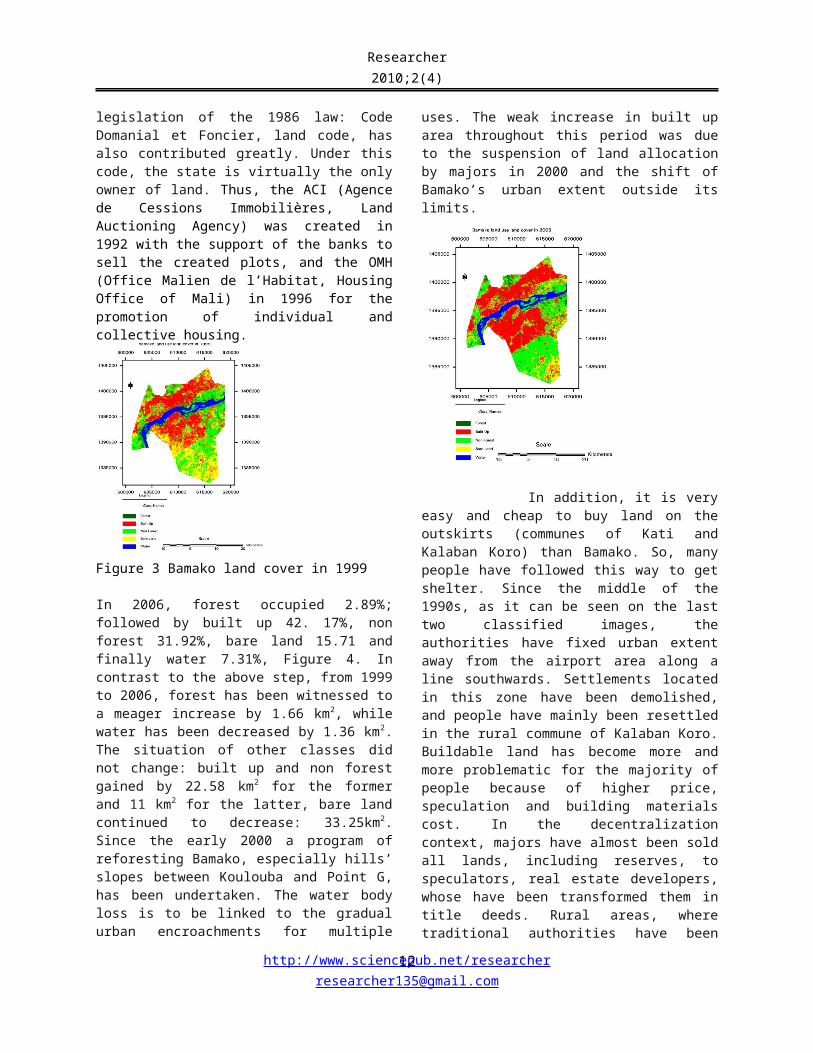
Figure 2 Bamako land cover in 1986
Figure 2 indicated that in 1986, forested area occupied 3.58%, built up 16.98%. Non forest, bare
http://www.sciencepub.net/researcher [email protected]
Researcher 2010;2(4)
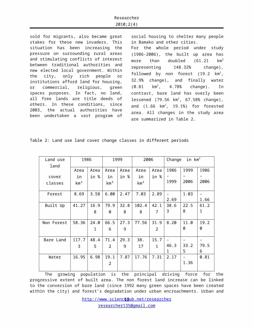
land, water are represented respectively by 24.01%, 48.46 and 6.98%. Figure 3 shows the changes in the land cover classes in 1999: forest, 2.47%, built up, 32.88%, non forest, 27.39%, bare land, 29.39%, and water 7.87%. During these thirteen years, forested area and bare land have been reduced by 2.69 km2 and 46.31km2 respectively, while built up gained by 38.63.km2, followed by non forest 8.2 km2 and finally water 2.17 km2. The reasons to the boom in the built up and depletion of forest and bare land can be explained by these elements. Since the beginning of the 1990s, socio-economic and political transformations have been occurred in Mali, with a slightly improvement of revenues. That in turn has increased the individual housing request. The cleaning up in the land tenure legislation of the 1986 law: Code Domanial et Foncier, land code, has also contributed greatly. Under this code, the state is virtually the only owner of land. Thus, the ACI (Agence de Cessions Immobilières, Land Auctioning Agency) was created in 1992 with the support of the banks to sell the created plots, and the OMH (Office Malien de l’Habitat, Housing Office of Mali) in 1996 for the promotion of individual and collective housing.
Figure 3 Bamako land cover in 1999
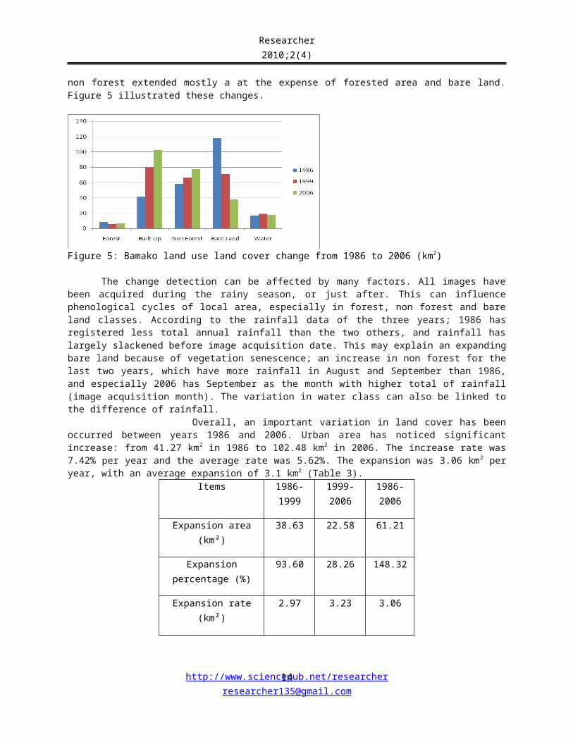
In 2006, forest occupied 2.89%; followed by built up 42. 17%, non forest 31.92%, bare land 15.71 and finally water 7.31%, Figure 4. In contrast to the above step, from 1999 to 2006, forest has been witnessed to a meager increase by 1.66 km2, while water has been decreased by 1.36 km2. The situation of other classes did not change: built up and non forest gained by 22.58 km2 for the former and 11 km2 for the latter, bare land continued to decrease: 33.25km2. Since the early 2000 a program of reforesting Bamako, especially hills’ slopes between Koulouba and Point G, has been undertaken. The water body loss is to be linked to the gradual urban encroachments for multiple uses. The weak increase in built up area throughout this period was due to the suspension of land allocation by majors
in 2000 and the shift of Bamako’s urban extent outside its limits.
In addition, it is very easy and cheap to buy land on the outskirts (communes of Kati and Kalaban Koro) than Bamako. So, many people have followed this way to get shelter. Since the middle of the 1990s, as it can be seen on the last two classified images, the authorities have fixed urban extent away from the airport area along a line southwards. Settlements located in this zone have been demolished, and people have mainly been resettled in the rural commune of Kalaban Koro. Buildable land has become more and more problematic for the majority of people because of higher price, speculation and building materials cost. In the decentralization context, majors have almost been sold all lands, including reserves, to speculators, real estate developers, whose have been transformed them in title deeds. Rural areas, where traditional authorities have been sold for migrants, also became great stakes for these new invaders. This situation has been increasing the pressure on surrounding rural areas and stimulating conflicts of interest between traditional authorities and new elected local government. Within the city, only rich people or institutions afford land for housing, or commercial, religious, green spaces purposes. In fact, no land, all free lands are title deeds of others. In these conditions, since 2003, the actual authorities have been undertaken a vast program of social housing to shelter many people in Bamako and other cities. For the whole period under study (1986-2006), the built up area has more than doubled (61.21 km2
representing 148.32% change), followed by non forest (19.2 km2, 32.9% change), and finally water (0.81 km2, 4.78% change). In contrast, bare land has overly been lessened (79.56 km2, 67.58% change), and (1.66 km2,
http://www.sciencepub.net/researcher [email protected]
Researcher 2010;2(4)
19.1%) for forested area. All changes in the study area are summarized in Table 2.
Table 2: Land use land cover change classes in different periods
The growing population is the principal driving force for the progressive extent of built area. The non forest land increase can be linked to the conversion of bare land (since 1992 many green spaces have been created within the city) and forest’s degradation under urban encroachments. Urban and non forest extended mostly a at the expense of forested area and bare land. Figure 5 illustrated these changes.
Figure 5: Bamako land use land cover change from 1986 to 2006 (km2)
The change detection can be affected by many factors. All images have been acquired during the rainy season, or just after. This can influence phenological cycles of local area, especially in forest, non forest and bare land classes. According to the rainfall data of the three years; 1986 has registered less total annual rainfall than the two others, and rainfall has largely slackened before image acquisition date. This may explain an expanding bare land because of vegetation senescence; an increase in non forest for the last two years, which have more rainfall in August and September than 1986, and especially 2006 has September as the month with higher total of rainfall (image acquisition month). The variation in water class can also be linked to the difference of rainfall. Overall, an important variation in land cover has been occurred between years 1986 and 2006. Urban area has noticed significant increase: from 41.27 km2 in 1986 to 102.48 km2 in 2006. The increase rate was 7.42% per year and the average rate was 5.62%. The expansion was 3.06 km2 per year, with an average expansion of 3.1 km2 (Table 3).
http://www.sciencepub.net/researcher [email protected]
Land use land
cover classes
1986 1999 2006 Change in km2
Area in km²
Area in %
Area in
km²
Area in %
Area in km²
Area in %
1986-1999
1999-2006
1986-2006
Forest 8.69 3.58 6.00 2.47 7.03 2.89 -2.69 1.03 -1.66
Built Up 41.27 16.98 79.90 32.88 102.48 42.17 38.63 22.58 61.21
Non Forest 58.36 24.01 66.56 27.39 77.56 31.92 8.20 11.00 19.20
Bare Land 117.73 48.45 71.42 29.39 38. 17 15.71 -46.31 -33.25 -79.56
Water 16.95 6.98 19.12 7.87 17.76 7.31 2.17 -1.36 0.81
11
Researcher 2010;2(4)
Items 1986-1999 1999-2006 1986-2006
Expansion area (km²) 38.63 22.58 61.21
Expansion percentage (%)
93.60 28.26 148.32
Expansion rate (km²) 2.97 3.23 3.06
Annual change rate (%) 7.20 4.04 7.42
Table 3: Area, Expansion rate and change rate for Bamako urban expansion in different periods
4.2 Driving forces During the past 50 years, most nations in Africa, Asia, and Latin America experienced rapid urban change. In Mali this phenomenon is increasing, especially in Bamako, the capital city. The central location of Bamako added to its situation along the Niger River banks played a great role in the city development. Geographic situation near water bodies is worldwide a significant factor for city development. According to UN-HABITAT (2008 a), cities located near the sea, along a river bank or in a delta tend to be the largest cities in all regions of the world, (14/19 megacities in 2007). Climate variability also can explain the rapid growth of Bamako. Since the 1970s, the Sahel region was facing to ongoing droughts.
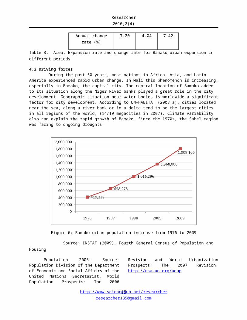
Figure 6: Bamako urban population increase from 1976 to 2009
Source: INSTAT (2009). Fourth General Census of Population and Housing
Population 2005: Source: Population Division of the Department of Economic and Social Affairs of the United Nations Secretariat, World Population Prospects: The 2006 Revision and World Urbanization Prospects: The 2007 Revision, http://esa.un.org/unup
In Mali, the 1987 demographic survey revealed that the reasons of migrating were drought (51.5%) and work or study (45.7%). Bamako is the principal destination for the migrants (35.9% of the resident population).
Table 4: Bamako urban population from 1976 to 2009
http://www.sciencepub.net/researcher [email protected]
Researcher 2010;2(4)
Years Population Source
1976 419,239 DNSI
1987 658,275
1998 1,016,296
2005 1,368,000 ESA/UN
2009 1,809,106 INSTAT
Source: DNSI, General Census of Population and Housing, 1987, 1998, INSTAT 2009
Source: Population Division of the Department of Economic and Social Affairs of the UnitedNations Secretariat, World Population Prospects: The 2006 Revision and Word Urbanization Prospects: The 2007 Revision, http://esa.un.org/unup
The district of Bamako offers many opportunities of jobs and urban services than any other city in Mali. From 419,239 in 1976 to 1,809,106 in 2009, Bamako’s urban population has been more than quadrupling, (332 % change), as indicated in Figure 6 and Table 4, while it has been increasing by more than thirteen fold 130,000 from 1960 to 1,809,106 persons to 2009 (1,292% change) .This trend will still continue for the decades ahead. For the period 2005-2020, there are 35 African cities among the world’s 200 most rapidly growing metropolitan areas. Bamako, Dar es Salaam, Kinshasa and Lagos are even among the world’s ten fastest growing large cities with their populations nearly doubling over these 15 years, UN-HABITAT (2008 a). This growth was due to both rural-urban migration and high fertility. Many authors (Barrios et al. 2006, Long et al. 2009) have been led studies on rural-urban migration and relationship. The growing population is costing in term of food, shelter, energy, and other services. To plan such needs, it is necessary to take into account the demographic measures (absolute change, percent change, average annual absolute change and average annual percent change). Wang and Hofe (2007) estimated that those demographic measures and others such as the composition of population by age and sex, the fertility, the birth rate, etc., are good indicators to know the increasing/decreasing of a particular population, then to plan infrastructures and services to the citizens. For
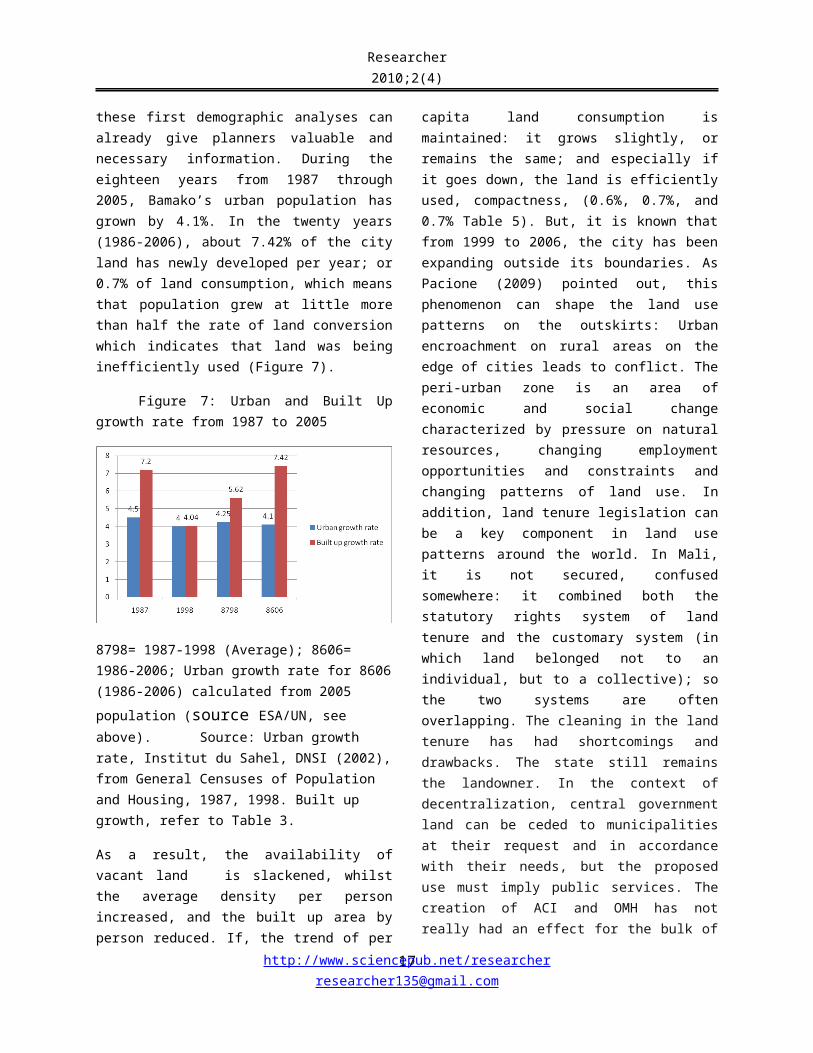
planning purposes, these first demographic analyses can already give planners valuable and necessary information. During the eighteen years from 1987 through 2005, Bamako’s urban population has grown by 4.1%. In the twenty years (1986-2006), about 7.42% of the city land has newly developed per year; or 0.7% of land consumption, which means that population grew at little more than half the rate of land conversion which indicates that land was being inefficiently used (Figure 7).
Figure 7: Urban and Built Up growth rate from 1987 to 2005
8798= 1987-1998 (Average); 8606= 1986-2006; Urban growth rate for 8606 (1986-2006) calculated from 2005 population (source ESA/UN, see above). Source: Urban growth rate, Institut du Sahel, DNSI (2002), from General Censuses of Population and Housing, 1987, 1998. Built up growth, refer to Table 3.
As a result, the availability of vacant land is slackened, whilst the average density per person increased, and the built up area by person reduced. If, the trend of per capita land consumption is maintained: it grows slightly, or remains the same; and especially if it goes down, the land is efficiently used, compactness, (0.6%, 0.7%, and 0.7% Table 5). But, it is known that from 1999 to 2006, the city has been expanding outside its boundaries. As Pacione (2009) pointed out, this phenomenon can shape the land use patterns on the outskirts: Urban encroachment on rural areas on the edge of cities leads to conflict. The peri-urban zone is an area of economic and social change characterized by pressure on natural resources, changing employment opportunities and constraints and changing patterns of land use. In addition, land tenure legislation can be a key component in land use patterns around the world.
http://www.sciencepub.net/researcher [email protected]
Researcher 2010;2(4)
In Mali, it is not secured, confused somewhere: it combined both the statutory rights system of land tenure and the customary system (in which land belonged not to an individual, but to a collective); so the two systems are often overlapping. The cleaning in the land tenure has had shortcomings and drawbacks. The state still remains the landowner. In the context of decentralization, central government land can be ceded to municipalities at their request and in accordance with their needs, but the proposed use must imply public services. The creation of ACI and OMH has not really had an effect for the bulk of people. ACI has early outpaced by the higher demand on the one hand, and the created plots are very expensive, just for an élite, on the other hand. Public housing is also criticized because of corruption in applications selection and exclusion of low income people. The outcome of all this was increasing of speculation, exclusion of poor people and sprawling of city, and depletion of reserves of land within the city. Poor people are constrained to deal with traditional landowners for obtaining plot; without basic infrastructures, and no title for land. This is a reason for spontaneous settlements rising.
Table 5: Average density, built up area per person
Measure T1(1986)
T2 (1999)
T3(2006)
Annual %
Annual %
Annual %
change change change(T2-T1)
(T3-T2)
(T3-T1)
Average density (persons/km²)
15,950.45 12,719.6 13,348.95 -1.73 0.70 -0.89
Built Up area per person (m²)
62.69 78.62 74.91 1.76 -0.69 0.90
Urban poverty has played a major role in the horizontal expansion and sprawling of the city till the remote rural areas. Farvacque-Vitkovic et al. (2007) reported that because of the insecurity of land tenure, residents deem this construction system to be more effective for acquiring housing and securing land tenure. Deeds acquisition can take two to three years for poor people, but for rich people, just two or three months with ACI. Sometimes, it is very difficult to make a difference between the city limits and the rural areas, so that it is very difficult to make an efficient planning for services; as Masser (2001) noted, monitoring and evaluating urban change is a major issue in urban planning and management throughout
the third world. Bamako’s urban extent is at the expense of the Cercle, (prefecture) of Kati and provokes many conflicts of interest with this prefecture, because district of Bamako is located inside Kati’s boundaries. Bah et al. (2003) reported that in the peri-urban settlement of Dialakorodji, in central Mali, men complain of the loss of agricultural land to residential use and see no benefit in the proximity of the city of Bamako now that, under economic reform many large employers such as peri-urban and urban factories have closed down or downsized their operations. As it can be observed on the last classified image, Figure 4, non forest area is widely expanded in the airport zone and some excessive slopes areas. These surfaces are for the moment unused as well as bare land in these areas. In addition all images have been acquired during the rainy season or just after. That mitigated the increase of non forest lands, (because most spaces are herbaceous which will be drier in the opposite season), which are scarce within the city, and limited possibilities of future urban expansion. Pauleit et al. (2004) observed that urban development has led to a decrease of green space at the level of the city region, as well as within the city itself.
The study revealed three main problems: the problematic of real estate management, the status of Bamako, and as a consequence of the two under growing population, the stress on the environment. Any development plan can be successful without available land resources. The carelessness and cupidity of some authorities have been leading to the depletion of reserves of land inside the limits of Bamako. Such attitudes prepare the ground for tomorrow urban violence (shelter riots and consequently, annihilate all plan for sustainable development. It is almost a general trend; all other cities are facing to this problem. Bamako is a district with special status since 1996. It has three administrative levels: every commune has its major, then; there is a central major of the district, and finally there is a governor. Every level of power has its prerogatives, but in most cases everyone interpreted laws according to his interests. It has been resulting conflicts of interests or negligence (for example for waste disposal collecting). Such hierarchy seems to be inappropriate and heavy. Bamako has a small surface, with the growing population the city has been expanding outside its limits. Bamako’s bulimia of land can lead to the question if it can continue to expand on
http://www.sciencepub.net/researcher [email protected]
Researcher 2010;2(4)
other lands with its actual status; or displace it, integrate others to it. It is a question which must be debated to anticipate the numerous consequences. The actual expanding politic has now altered the surrounding rural landscapes with the waste dumping.
4.3 Environmental consequences
Urbanization is one of the most pervasive anthropogenic land conversions, which can significantly affect the land cover and landscape characteristics in considerably short period of time Li et al. (2006). A huge population, almost living in informal settlements 45% in 2002, Farvaque-Vitkovic et al. (2007), obviously caused harmful effects on the environment. All the city‘s needs are costing for the nature, especially for Bamako which has a slighter space. So, population pressure on natural resources is obvious. Kusimi (2008) indicated that, besides food supply, an increase in population leads to urbanization putting stress on the surrounding lands for housing consequently causing forest degradation. The concentration of population and economic activities in cities has degraded the quality of their environments, especially in the Third world ones. The principal problem is pollution, due mainly to the domestic and industrial wastes. This situation can lead to drastic alterations in ecosystems. The situation, Pacione (2009) depicted: Many cities in Asia and Africa have no sewers, and most human excrement and waste-water ends up untreated in watercourses, gullies and ditches, is suited to Bamako According to the 2005 data of Ministère de l’Environnement et de l’Assainissement, Ministry of Environment and Sanitation, the annual industrial liquid waste was 1,825,000 cubic meters rejected without appropriate treatment (contained in chemical and organic pollutants and heavy metals) in the Niger River plus 16,000 cubic meters for dyeing liquid, also expanded on land, or in sewers. Aquatic ecosystems are threatened of extinction with such volume of pollution, as well as the riparian and shallows ecosystems. Household liquid waste is also important, and is largely expanded on land where the sewerage system is not effective. The annual amount of solid waste is estimated to 9,715 tons, only 40% reached final destination. The nitrites content of wells in some neighborhoods is too much high: 2.23 mg/l in Bozola and 145.2 mg/l in Niaréla against 0.10 mg/l for the normal. Air, also, is polluted mainly by means of transportation and industries. The principal pollutants are nitrogen and sulfur oxides, carbon dioxide, and some metals like plumb. The depletion of forest led to the loss of biodiversity and increased the risk of local, as well as global climate change. Cities are at the heart of landscape change and climate change, which caused
harmful effects on human being. Donnay et al. (2005) argued that metropolitan agglomerations and urban settlements are the most intensive forms of land use yet devised. In recent years, some of the most drastic alterations to local climate (micro-climate) have been associated with them, with consequent impacts on the health and quality-of-life of their human inhabitants. The increasing informal number of quarry sites is a factor not only of pollution, but also of erosion, landslides, destruction of sensitive ecosystems. The health and well-being of citizens are compromised by the degradation of urban landscape. Surrounding areas are also affected by environmental change caused by the solid wastes of Bamako. Increasing competition between agricultural and residential use of natural resources is at the heart of overt conflict around the town of Himo in northern Tanzania, whereas waste dumping from Bamako is a major problem in one of the city’s peri-urban settlements, Bah et al. (2003). A similar kind of rural environment degradation is observed (Shang and Liu 2009) in the Northeast of China.
5. Conclusion and recommendations
The study has demonstrated that the district of Bamako has experienced a great change in land use and land cover under the period of study. Built up area is increasing, whereas forested land is reducing. The mismanagement of land can compromise the sustainable development. The problems of land use/land cover change, the district of Bamako is faced, must be solved by a multidisciplinary approach. The authorities of the district of Bamako must integrate new technologies, such as remote sensing and Geographic Information System into their decision making. Using remote sensing data and information to understand the dynamics of the urban environment may contribute to better policy and urban management. For sustainable development, some actions should be undertaken. A wise assessment of land resources and land management plan for multiple uses at all scales should be carried out for responding to the needs of increasing population. A unique authority of land and environment (under a single ministry authority) should be created for managing, allocating, and assessing different land use impacts on the environment. It should be integrated representatives of all ministries interested in land and environmental questions. This should facilitate a synergy of actions; compensate the lack of human resources (specialists), and integrate a multidisciplinary vision in the decision-making. Bamako administrative hierarchy should be revised to reduce multiple decision levels (a central major should be preferred for efficiency of actions), as well as the status of the district in response to the reality of the
http://www.sciencepub.net/researcher [email protected]
Researcher 2010;2(4)
moment. Environment protection should be integrated to habits by public awareness to the environment and the implementation of laws to diminish the lack of sense of citizenship. A study of pollution level of the Niger River and its implications on ecosystems chain should be made. Environmental impact assessment should be integrated in all manufacturers’ activities. Acknowledgements
I would like to thank the National Directorate of Meteorology, especially Djibrilla Ariaboncane MAIGA and Modibo Samba COULIBALY; the Geographic Institute of Mali, particularly Ando GUINDO, Bréhima DIEGUENI and M. TOURE, and finally Djibrilla Issoufa MAIGA of Lycée Mamadou SARR for supplying data.
Correspondence to: Boubacar Amadou DIALLO
Department of Geography, China University of Geosciences, Wuhan, China BP 430074, Lumo Road 388 Tel:00862759839734/ 00862713628615483 [email protected]
References[1] Al Fugara, A. M, Pradhan, B, Mohamed, T.A. Improvement of land-use classification using object-oriented and fuzzy logic approach. Appl Geomat 2009; 1:111–120. DOI 10.1007/s12518-009-0011-3 [2] Angel, Sh., Sheppard S.C., Civco, D. L et al. The Dynamics of Global Urban Expansion, Transport and Urban Development Department, 2005. World Bank, Washington http://www.williams.edu/Economics/UrbanGrowth/DataEntry.htm.[3] Bah, M., Cissé, S., Diyamett, B., Diallo, G., Lerise, F. Okali, D., Okpara, E., Olawoye, J, Tacoli, C. Changing rural-urban linkages in Mali, Nigeria and Tanzania, 2003. Environment & Urbanization Vol 15 No 1 April 2003. http://www.iied.org/rural_urban/downloads.html#UPWPS [4] Barrios, S., Bertinelli, L, Strobl E. Climatic change and rural-urban migration: The case of sub-Saharan Africa. Journal of Urban Economics 2006; 660 357-371. DOI:10.1016/j.jue.2006.04.005 [5] Donnay, J.-Paul, Barnsley, M. J., Longley, P. A. Remote Sensing and Urban Analysis. Taylor & Francis 2005; e-Library, New York ISBN 0-203-30606-6 Master e-book [6] Farvacque-Vitkovic, C., Casalis, A., Diop, M., Eghoff, C. Development of the cities of Mali- Challenges and Priorities, Africa region Working Paper Series No.104/a World Bank, Water and Urban
Development Division II (AFTU2) 2007. http://www.worldbank.org/afr/wps/index.htm. [7] Geymen, A, Baz, I. The potential of remote sensing for monitoring land cover changes and effects on physical geography in the area of Kayisdagi Mountain and its surroundings (Istanbul), GeoJournal 2008; 71:249–259. DOI: 10.1007/s10661-007-9844-6[8] INSTAT. Fourth General Census of Population and Housing (temporary results 2009. http://www.instat.gov.ml[9] Institut du Sahel, DNSI. Profil démographique et socio-économique du Mali 1960-2000, 2002; ISBN 2- 912693-33-0[10] Kusimi, J. Manyimadin. Assessing land use and land cover change in the Wassa West District of Ghana using remote sensing. Environ Monit Assess 2008; 140:33–42. DOI: 10.1007/s10708-008-9172-6 [11] Li, Y., Zhao, S., Zhao, K., Xie, P, Fang, J. Land-cover changes in an urban lake watershed in a mega-city, Central China, Environmental Monitoring and Assessment 2006; 115: 349–359. DOI: 10.1007/s10661-006-6559-z [12] Liu, Y. Modelling urban development with Geographic Information System and Cellular Automata, Taylor & Francis Group, LLC, 2009; ISBN- 10: 1-4200-5989-0 [13] Long, H, Zou ,J, Liu, Y. Differentiation of rural development driven by industrialization and urbanization in eastern coastal China. Habitat International 2009; 33 454-462. DOI: 10.1016/j.habitatint.2009.03.003 [14] Masser, I. Managing our urban future: the role of remote sensing and geographic information systems. Habitat International 2001; 25 503–512. PII: S 0 1 9 7 - 3 9 7 5 (0 1) 000 2 1 – 2 [15] Miller, R. B, Small, C. Cities from space: potential applications of remote sensing in urban environmental research and policy. Environmental Science & Policy 2003; 6 129–137. DOI:10.1016/S1462-9011(03)00002-9 [16] Ministère de l’Environnement et de l’Assainissement. Rapport national sur l’état de l’environnment (2005) 2006; http://www. environnement.gov.ml [17] Pacione, M. Urban geography. A global perspective, Third edition, Routledge Taylor & Francis Group 2009; ISBN 10: 0–203–88192–3 (ebk) [18] Pauleit, S., Ennos, R, Golding, Y. Modeling the environmental impacts of urban land use and land cover change- a study in Merseyside, UK. Landscape and Urban Planning 2004; 71 (2005) 295-310. DOI:10.1016/j. landurbplan.2004.03.009 [19] Population Division of the Department of Economic and Social Affairs of the United Nations Seccretariat, World Population Prospects: The 2006
http://www.sciencepub.net/researcher [email protected]
Researcher 2010;2(4)
Revision and World Urbanization Prospects: The 2007 Revision, http://esa.un.org/unup [20] Shang, J, Liu, Y. Situation of rural ecological environment and management system Innovation in Northeast major grain producing areas. World Rural Observations 2009;1(1):24-28, ISSN: 1944-6551. [21] Treiz, P, Rogan, J. Remote sensing for mapping and monitoring land-cover and land-use change-an introduction. Progress in Planning 2003; 61 (2004) 269–279 273. DOI:10.1016/S0305-9006(03)00064-3[22] UN-HABITAT. State of the world’s cities 2008/2009. Harmonious cities 2008; ISBN: 978-92-1-132011-4 (UN-HABITAT hardback)
[23] UN-HABITAT. The state of African cities 2008. A framework for addressing urban challenges in Africa 2008; ISBN: 978-92-1-132015-2[24] Wang, X, Hofe, R. Vom. Research methods in urban and regional planning. Tsinghua University Press, Beijing 2007; ISBN 978-7-302-13785-6. Springer Berlin Heidelberg New York, ISBN 978-3-540-49657-1[25] Wells, T. Land Tenure and the Cadastral System of Mali, University of Maine, Department of Spatial Information Engineering. Cadastral and Land Information Systems 1999; SIE526
07/04/2010
http://www.sciencepub.net/researcher [email protected]